Showing posts with label Walkable Urbanism. Show all posts

Thursday, February 17, 2011

All Veneer Work and No Dentistry

Main Street gets all the attention and Elm and Commerce are left behind

The long-at-work Downtown Dallas 360 plan is all but finalized having been presented yesterday to the Downtown Dallas yearly luncheon. The Dallas Observer is citing its "bold ideas and quick wins." But how bold are the ideas and how quick are the wins?

There are some good things to the plan (which I'll mention), but the lack of ambition, vision, and screw boldness-how-about-audacity in correcting the real ailments of downtown were left behind. That's not very Dallas or Texan. I'm not sure any city became "world class" by compromising and focusing only on veneer work when real dentistry was necessary.

The three major problems afflicting downtown that are barely tended to are:
  • The inner freeway loop
  • The tunnels
  • Property owners perfectly happy to sit on un(der)developed properties, i.e. parking.
There are other ailments, many of which cosmetic and thus they actually get addressed. My contention however is that the real problems aren't cosmetic but systemic. The 360 plan is too focused on the urban phenotype, or physical appearance and not enough on the urban genotype, or the genetic wiring of place. The physical issues are more often than not and outgrowth of the genotype, much like how our bodies work.

We won't fix the underlying genetic issues, those that make living systems function properly, only through plastic surgery. Furthermore, those "medical procedures" end up requiring long-term and consistent subsidy to continually resuscitate a dying system, like its on a breathing machine and the family isn't quite ready to pull the plug.

The solutions proposed (or implied) for the above are:
  • lighting up underpasses or use of artwork - much cheaper than building a park over a freeway, but there is a similarly minimal return on investment ratio on this. Whereas removing sections of freeway altogether repositions acres and acres of land for redevelopment. They're instantly better connected and more desirable therefore raising demand, which reveals itself through density. If somebody considers this financially ludicrous, it would pay off at least ten-fold in new development, density, tax-base, and that strange, elusive value-multiplier of real urbanism - i.e. a highly interconnected local network, the foundation of all living systems. If your brain only made synapses between the most distant cells, you'd have an aneurysm, kind of like traffic on a highway acts to the local economy each day.
  • hope subsidized ground level retail will outperform below-grade retail. Even if it does, the availability of the 3-dimensional pedestrian grid (above-grade: pedestrian bridges, at-grade: on-street, and below-grade: tunnels) will dilute the energy of any of the above "planes." Energy from one "corridor," a convergence of linkages to destinations only spill over when it becomes too crowded. We lack the density of say, New York City, which allows the High Line to work apart from the street-level transportation network. Commercial activity requires a concentration of movement to survive (at least, those businesses that are built on physical movement to/through/past their enterprise).
  • Ummmm... I've heard rumors from some high level people, but there is no concrete policy yet for developing properties that could be considered performing (at least to the owner). Surface parking is a revenue generator for the land owner, but a net loss for the entire neighborhood around its function and land value. I've always supported a split tax approach (subject to state legality) that distinguishes improvement from land in its tax rate. This punishes underperforming properties and provides incentive for having property that participates positively in the urban network.
-----------------------------
On the other hand, some of the highlights of the plan include the "glass box retail." I don't care for the cliched design description, but functionally it is necessary to replace the few areas around town that are currently used as micro-dog walking parks. I'm thinking particularly of Pegasus Plaza on the backside of the Magnolia Hotel and the little green patch in the nook of the DP&L building. These are backs of buildings fronting plazas (and pedestrian connections) that need to become active interfaces, frontages.

The other positive is the prioritization of the primary street framework through downtown. These being Ross, Griffin, Main, Young, and the Olive/Harwood craziness. It is necessary to improve the overall aesthetics and function of priority connectors. The reason is because of the two-tiered (but interconnected) planes that define cities.

The top level is the primary structure, the bones, that create the framework of the city. These areas will carry the most traffic (ideally of all forms of transportation in order to truly move the most amount of people) and therefore must receive the most amount of attention to detail design and function. The most people, the most stress, the most potential value that is directly connected to the attractiveness but often undermined by poor functionality and aesthetics.

The street is undesirable therefore the most valuable places (because of the amount of movement) are the least capitalized upon. The most valuable websites receive the most amount of traffic. They're the most desirable and therefore must have the best interface to reach its potential for traffic, value, and commerce. Have a shitty website, drive away business. Have shitty primary street network, which we do, drive away value...out to the 'burbs.

The secondary level is the residential backdrop. A framework of neighborhoods organized around and arranged to the amenities created by the primary street framework. If you drop the ball in meeting potential, it repulses the potential for neighborhood self-organization, aka demand to live near amenities. The residential often gets priced away from the primary streets because of the commercial value, but if the streets/spaces are designed well enough and to accommodate high degree of local connectivity (i.e. walkability) there is HIGH value for residential snuggle up as close as can be afforded to that primary network. Want to know why so many areas of Manhattan cost so much?

------------------------

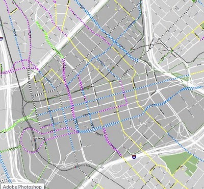
So far so good, except that as I mentioned, these streets have to move the most amount of people. It is troublesome that neither the downtown 360 plan NOR the bike plan address Elm and Commerce in any meaningful way. See below:


Main Street gets all the attention. Elm and Commerce are the forgotten step children. That's a quick win that will get all the attention, prettying up an already functional street. But, does it actually help to make downtown significantly better in the way that it functions as a living system built upon network density.

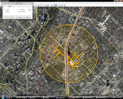
Let's run through a little experiment to explain why Elm/Commerce need more attention, then Main can get prettied up:


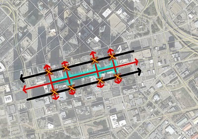
Red represents Main and its connections. Elm/Commerce one-way couplet is in black.

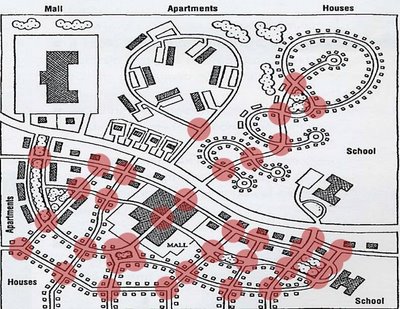
Too often when we think of streets and their functions (particularly in downtowns) we focus too much on the link between point A and B, as if people only drive from the start of a street to the end of it. What we forget is that the purpose of a street is to ALSO facilitate the crossing of that street as part of an adaptive, functionally interconnected network.

Elm and Commerce are both functionally dead for local connections. They're functioning perfectly in a "get the hell outta town sorta way." Also known as, exactly as they're designed. They're too wide and too one-way, and therefore too high speed. Elm and Commerce are dysfunctional streets. Empirically, go out there any day or evening. They are strictly about long distance connections and thereby sever local connectivity. Pedestrians aren't there. Businesses flounder. They effectively box in the life of Main Street, the pulse of the downtown neighborhood. Elm and Commerce are like the tourniquet cutting off blood supply.


So if we're to apply some simple math to this area, let's value functioning streets/intersections as +1. They are positive and contribute to a successful urban network. Dysfunctional streets, those that cut off local connectivity get a -1. They're reductive (almost as much as this example).

Total value of these intersections: -4


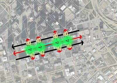
The plan is to make Main Street prettier. And there is some logic to that. As I stated above, it is the most experienced by pedestrians, the most heavily trafficked, therefore it needs the greatest attention to detail for people to touch, feel, and experience. A +1 street becomes a +2 street.

To date the efforts to "improve" Elm and Commerce have been cosmetic: some benches, maybe a tree or two, some new paving and light fixtures. But the function, its role within the network, is in no way improved. The street remains as a -1.

Total value of these intersections: 0


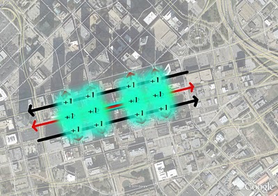
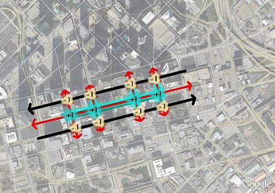
On the other hand, if Elm and Commerce were redesigned to facilitate pedestrian connectivity, crossing and the overall interconnectivity (particularly locally), the entire system begins to function better. There are several ways to do this, all of which should slow traffic, either through letting the eventual streetcar run on these streets (thus slowing traffic as on McKinney), widening sidewalks, allowing more parallel parking, creating cycle tracks for segregated bicycle flow. If these streets/intersections can go from dysfunctional (-1) to functional (+1), then the real estate along them will become more valuable, thus reinforcing Main Street and perhaps even raising the taxbase to the point that it makes more sense to spend on improving Main Street.

Total intersection value: +12, i.e. the "urban exponent" of highly interconnected places.

I'll bet with the house. The fundamentals of living systems always win. But, they're betting the other way.


Wednesday, February 9, 2011

Linkages - Edjamacashun Edishun

Charles Marohn, a transportation engineer who gets it, writes at the New Urban Network about the high costs of busing kids to school:

If I am reading the budget right, we are going to spend $3.4 million in transportation costs this year. That seems in line with the costs reported in the MN2020 report. With a starting teacher in the district making roughly $41,000 in salary and benefits, we could add over 80 new teachers right now if we stopped subsidizing busing. That would be a 20 percent increase in staffing, potentially a game-changing amount.

Here's my proposal: What if we abolished the mandate that schools provide transportation to all students, but required them to still provide it to children that lived on farms (or whose families had careers that required them to live in a remote location)? For all other children, transportation would be provided as a fee-for-service offering. We then subsidize children from poor families (many of whom live close to the old schools anyway).

Besides the fact that it is nearly politically impossible to get people to pay for something they have been receiving for free, what are the objections?

It makes no sense that we continue to abandon neighborhood schools in favor of these remote campuses that require every child to be bused to. The only reason this continues to happen is that we've made transportation a sunk cost — it has to happen anyway — and so the cheapest way to do it is to make it large-scale. In the meantime, the transportation mandate is simply another perverse incentive for people to make lifestyle choices that ultimately have huge, financial costs to society.

At the link, he also discusses the design of the school and the area immediately around it. It's on a highway (or something close to it). No child could walk to it if they wanted and if some parent actually did allow such action, they would immediately get a call from protective services. Likely from somebody on a cellphone driving down said highway before they sideswipe another car because they failed to use a blinker while talking on said phone.

The budget Chuck mentioned above is for one (1) school district. We're about to cut teachers left and right, most disconcerting, in positions where they're needed the most such as special education. What is next? Why even have schools? Wouldn't that be cheaper? Isn't that the defining goal? Just rent some space from giant auditoriums and concert halls and have the one teacher left (the youngest, cheapest, and most inexperienced of course), lecture on all subjects to 1,000 kids at a time.

Or maybe, smaller, more localized schools was actually a better way of caring for and preparing children to be prosperous contributors to society.
-----------------------------------
Next Question: Is Density a necessity for educational achievement?

So, if most American students live in lower density places than their peers in Europe and Asia, could it be possible that this-in part-is a reason for lower performance on science and math tests, which are basically a series of challenges or problems to solve.

Do children in higher density areas encounter informal problem-solving challenges far more frequently than their suburban counterparts and therefore have had more practice, more opportunity to hone their problem-solving skills? The urban challenge may be how to communicate with someone from another country, or how to navigate a Razor scooter down a busy sidewalk, but it’s still a problem to solve. In one recent series of tests, students from rapidly growing and changing Shanghai were tops in the world. Coincidence?

If density matters for economic productivity and innovation productivity, surely it matters for education productivity.

I don't buy the simplicity of the equation, Density + Education = Gold Stars! There are so many fundamental policies that hamper education, i.e. rote memory, teaching to the test, etc., that it couldn't possibly be that simple. But, there are a few contributing factors of certain kinds of density that propel higher achievement.

First of all, that density has, HAS to be a product of desirability. Shoving people into Bed-Stuy, Cabrini Green, Pruitt-Igoe style tenements doesn't equal brain power. However, if a place is desirable, people will move in, including a range of tax brackets, thus increasing tax base.

Furthermore, as mentioned above, density would allow for reduced required transportation costs, allowing some combination of lower property taxes and increased programs for students or better teacher pay. Or all 3, huzzah!

Lastly, increased density would likely mean more walkability (as long as said density is due to said desirability. If it is not, as in say, LoMac part of uptown Dallas where residential towers are set within suburban style spaghetti of dangerous streets, kids would still have to be transported safely from point A to point B. Thus, eliminating the rest of this point, which is...) Increased walkability means increased personal responsibility for adolescents and young adults.

I noticed this living in Rome where middle schoolers were responsible for their own transit (and that of their friends) to/fro school each day. I was struck by how much more mature they seemed than American kids. Call it anecdotal. Call it a hunch. Call it intuitive. I would bet there is a direct correlation to childhood dependence for transportation to virtually everywhere with the delayed emotional and psychological maturation that has led psychologists to suggest that adolescence is no longer 12 to 18 but more like 18 to 35.

Now I'm gonna go play in the snow since I'm not yet grown up.

---------------------------------------


Tuesday, November 30, 2010

Tuesday Linkages

The first article today is an interesting one from SmartPlanet about our cognitive maps and getting lost in buildings. They go on to blame architects who have incredibly advanced understanding of space in three-dimensions:

What they found:

  • People navigate differently. Some use contextual clues — “Make a right at the stairwell” — and some use cardinal directions to find their way.
  • Cognitive maps are prone to bias, and can distort reality. Culture and gender are factors.
  • The design of a building exacerbates these effects, thanks to identical-looking corridors, short lines of sight and asymmetrical floor layouts.

The more difficult the building, the more a person must rely on their (imperfect, incomplete) cognitive map.

Take the award-winning Seattle Central Library: the first five levels of the library defy expectations and are all different — so different, in fact, that the outside walls don’t always line up. Sight lines could help ease the shock, but the library’s long escalators skip floors, making it difficult to see where they begin and end.

Interestingly, the researchers says that architects have such strong spatial skills — they make three-dimensional space from two-dimensional blueprints, of course — that they may fail at imagining their design from the perspective of someone with poor spatial skills.

What they are saying is that architects are increasingly pushing the limits of how to comprehend and think about space in 3-dimensions. You might call this innovation. You also might call this selfish. Are they the end user of this space? Often not. The end users typically don't appreciate the mental gymnastics it takes to make a Seattle Public Library or a Denver Art Museum. Dummies. They deserve the vertigo.

I cite these two buildings specifically because I have visited the Seattle Public Library. It was loud and uncomfortable, exactly what you want from a reading room. I'm not typically afraid of heights or have trouble intuiting spatial relationships and suggested pathways. I felt like this building was going to collapse and I wanted out of it as quickly as possible. As for the DAM, many people have left claiming feelings of nausea. One can't say if it was the odd angles of the buildings spaces and corridors, canted for Libeskind's self-gratification or the art within.

Contrast this with the architects and designers in Renaissance times that wanted to understand human proportion, scale, and awareness of space. The designs reflect it.

Design for people. Not other architects or Architectural Record.
----------------------------------------
In what might as well be called Pravda, an online journal called "Gensler On" interviews, you guessed it, a Gensler principal about Gensler type of projects, big ones. In this case, it comes off as some sort of cheerleading for times of yore when money flowed like wine into skyscrapers that remarkably no one moved into and banks were healthy and raking in cash and not failing all over the world because of faulty supply driven investments. Run-on, I does it.

The actual article is called, Can Super Tall Buildings Be Green?, which could make for a perfectly fine article if you wanted to argue something beyond "tall is dense" and "tall is aspirational." I'd quote it, but there is really nothing of substance there and I find it hard to believe this was written in this century let alone this decade rather than 1995 or 2005, which the rationale mirrors.

First, tall is dense, yes. But tall can be another form of sprawl. By sending people further up into the sky, that creates demand for services to follow them upward. For example, a 100-story tower will have cafes or coffee shops or "sky gardens" and different things every 20-floors or so. Amazing, we like things close to us.

He undermines his own argument suggesting super tall is necessary for street life and that he's from NYC. The best parts of NYC and Vancouver are not the skyscrapers. It is the street life between the smaller buildings, that don't dominate the sunlight, necessary for actual street life and just plain life, such as trees.

Second, the tall is aspirational argument is another form of quantitative growth that got us into this economic morass. Quantitative growth took on two forms of real estate, outward growth (sprawl - Vegas, Phoenix) and upward growth (Miami Condo towers, Dubai), or even the rare outward and upward like Chinese pop-up cities. All of which are supply-side. There was little to no real demand, which is why they 1) attracted speculation and 2) are now empty.

Furthermore, the entire market was rather nefarious, not just because of the banks handiwork, but because of all of the corrupt 3rd world money finding its way into American, London, Indian, and Chinese real estate. Dirty money and imaginary money is no way to run an economy or build a city.

Your architecture firm, staffed and structured to work on these kinds of projects, has a very short future in its current iteration. I've never thought of Gensler as thought leaders on cities, ever, but that won't stop them from telling you they are and cheerleading for a return to the boom decade of the noughties.

Some day banks will wisen up and start investing only in projects that improve quality of place and are based in real, demand-driven fundamentals. It is in their financial interest to do so.
----------------------------------------
To end on two happy notes, we'll shift to places focused on qualitative growth, or the improvement of their cities:

The Irish Times visits Freiburg, Germany looking for lessons:

Prof Kevin Leyden, an American now based at NUI Galway’s Centre for Innovation and Structural Change, was struck by how hard Freiburg has “worked and planned to be energy-efficient and carbon-conscious as well as creating real neighbourhoods with a sense of place. There is also a commitment to green space, playgrounds and local shops”. Dr Daseking, who has been Freiburg’s chief planner for 27 years, said the “breaking point” came in the early 1980s when the city council decided that big shopping malls on the outskirts would be “zoned out”. As a result, smaller shops had the chance to survive and “people get their daily requirements by walking or cycling, not driving”.

One of the stupid things Dublin did, and Freiburg didn’t do, was to get rid of its trams.

As a result, the city’s tramlines - running from north to south and east to west, with the main station as the network’s hub - were extended to serve new “fingers” of development stretching out in all four directions - including new suburbs like Vauban and Riesefeld.

Housing is socially mixed, with rich and poor living in close proximity, on remarkably quiet streets devoid of through-traffic. Children play in green areas or quite safely on the streets. “By building like this, you can influence the use of cars,” Dr Daseking said. “Freiburg has only 440 cars per 1,000 in population, but in Vauban it’s only 85 per 1,000”.

And the ten most walkable cities from Frommers via the Infrastructurist:
1. Florence
2. Paris
3. Dubrovnik
4. New York City
5. Vancouver
6. Munich
7. Edinburgh
8. Boston
9. Melbourne
10. Sydney
Since it is from Frommers, guessing it is geared to bigger, more tourist destinations. The key to walkability is proximity, density of network (moreso than density of people), which means density of movement corridors, the type of movement corridors that allow for density of networks (grids vs. dendritic highway/arterial), and quality of spaces (streets, sidewalks, plazas, public spaces).


Monday, November 22, 2010

The Blind Nature of Walkscore

I've written ad nauseum about the shortcomings of WalkScore. It is a step in the right direction, but like all statistics, an abstraction. Or in some cases, lies or damned lies. WalkScore even admits where their ratings often go afoul and are working to correct this in beta versions that measure diversity of neighborhood services rather than the mere presence of some/any.

Furthermore, it is a quantitative analysis to express the qualitative, which can't be quantified. Follow my drift? In other words, they express walkability strictly by proximity (which is necessary), but not by quality of the walk. Are there sidewalks? Are they wide enough? Are the buildings constantly changing and engaging to maintain interest and foreshorten the walk? Are cars a threat? Are others around to ensure some measure of common trust and safety?

In a way, it measures the skin to explain bone structure. Not quite accurate or scientific, but better than nothing. And, if anything, it represents a collective shift in priority and awareness that it has caught on at all.

One specific example to even further the disparity between superficial and subcutaneous, Main Street in downtown Dallas is considered the most walkable in all of DFW. Not a stretch, but that it is a 98 out of 100, might be. Is it really as walkable as Center City Philadelphia? Portland? Old town Alexandria, VA? Surely not, but I can accommodate my daily needs here. It is inflated because of the issues mentioned above and it counts tunnel businesses which are mostly only open 11am to 2pm, serving the office population which swells above 150,000 each day from a night time (permanent resident) population of about 5,500.

So I'd like to add two things. First, an email from a friend, occasional blog contributor, and reader:
Just thought it interesting to see Walkscore got metro-wide heat maps now, but still amused to find my old neighborhood scores higher (86) than my new neighborhood (83). Attached pics.

In fact, they made a correction a few months ago that I submitted that accurately made the park much closer than they indicated, boosting the neighborhood up to an 89. I just checked now and that's gone.
Old Neighborhood (86)


New Neighborhood (83)


Now that they do have heat maps, let's look at some:


Austin:


Dallas:

You'll notice the green dots as downtown (brightest), with uptown and deep ellum latching on, lakewood, fair park, and bishop arts as some of the others. Striking how poorly Ross Ave corridor ranks particularly in relation to all that is around it. Seems like a great opportunity to stitch several parts of town together...wonder where I got that idea...

Houston:


Philadelphia:


DC:

Monday, October 25, 2010

Inner Growth

Leinberger in the Washington Monthly sums it up that outward expansion, stuffing ourselves with suburban cake, is coming to a merciful end. Time to shape up, qualitatively improve ourselves rather than quantitatively as measured by weight, girth, body fat, etc...cuz if we are our cities, and our cities are our economy, it is loaded up with lard currently. Gooey, gelatinous, wasteful excess baggage that must be shed.

Instead, our only choice is that of health: getting smarter, stronger, healthier, with a more efficient circulatory system (transpo) and greater lung capacity (natural environment). There is no magic pill for that. Only will, dedication, and hard work. Time for all of America to be a contestant on the Biggest Loser...or we could just stick are head in the sands, fingers in our ears, lalalalalalalala can't hear you, and hope the mean world just blows away like the last tornado warning:

In the postwar years, America pushed its built environment outward, beyond the central cities, creating millions of new construction jobs and new markets for cars and appliances—a virtuous cycle of commerce that helped power American prosperity for decades (until, of course, it went too far, leading to the oversupply of exurban development that is acting as deadweight on the current recovery). The coming demographic convergence will push construction inward, accelerating the rehabilitation of cities and forcing existing car-dependent suburbs to develop more compact, walkable, and transit-friendly neighborhoods if they want to keep property values up and attract tomorrow’s homebuyers. All this rebuilding could spur millions of new construction jobs. But more importantly, if done right, with “smart growth” zoning codes that reward energy efficiency, it would create new markets for power-conserving materials and appliances, providing American designers and manufacturers with experience producing the kinds of green products world markets will increasingly want.

In addition to fueling long-term economic growth, the new demand for walkable neighborhoods could provide other benefits. One of the biggest drivers of rising health care costs is the expansion of chronic diseases like obesity, diabetes, and heart disease—conditions exacerbated by the sedentary lifestyles of our car-dependent age. All would be substantially reduced if Americans move into higher-density, transit-friendly neighborhoods in which more walking is built into their daily routine.

Wednesday, October 20, 2010

Uptown Girl Needs a Better Block

Over at Better Block.org, they've got video of Billy Joel's version, inspired by the initial efforts here in Dallas.

48x48x48 Oyster Bay from Jennifer Macchiarelli on Vimeo.

Monday, October 18, 2010

TOD Galore

A new massive database has been assembled and released at large by the Center for Neighborhood Technology and the affiliated Center for Transit-Oriented Development (TOD). The direct link to Dallas is here, we'll see if that works for you, since you have to be a registered user to access it.

Below is a sample where they map all existing and proposed transit stations and with a click will return population, # of jobs, and median income within a 1/2 mile radius. Let's see if you can guess my one issue with it:


Get this far? Well, my one and only problem is inherent to such massive assemblies of data. Each of these TOD zones requires specific attention to detail. This gets at a broader problem preventing TOD planning from becoming smarter, and that is the ubiquitous 1/2-mile walk circle.

The issue with the 1/2-mile circle, intended to simulate a 10-minute walk or a popularly accepted distance to travel by foot to transit stations is that not all 10-minute walks are the same. What is the road network like within that 1/2-mile generic circle? How many roads must be crossed? How direct is the route (yielding a more radial pattern emanating from a center of gravity or attractor - in this case the transit station)? Are there highways to be traversed? How long is the wait to cross at crosswalks, etc. etc.?

This is the type of thing that can really only be field tested and I apologize for not doing that here. Instead, I did a quick estimate based on distances and first-hand experience of riding DART to the CityPlace station and walking to various destinations (Target/West Village) several times. Below is a quick map of that.


Click to get a closer look.

As you can see, what actually constitutes an acceptable walking distance is FAR, FAR smaller than the 1/2-mile circle, because it takes a similar amount of time. In the case of CityPlace station, being 20,000 leagues beneath the sea of traffic on North Central Expressway is its problem as surfacing from the subway station can take at least 5-minutes unless you're in the mood for 2-minute thighs and feel like running up the monumental stairwells that are only missing the monument.

Other areas of the city would actually come far closer to the actual perimeter of this circle. To do so, would require a tightly-knit grid of smaller, easily crossable, pedestrian-oriented streets, preferrably in a more radial pattern than perfectly squared gridiron. The reason for this is that it creates more direct routes based on desire lines (if the transit-station is the most desirable destination in the area). Obviously, this exists only in a perfect world which over time balances the competing desire lines to other destinations.


Example of a "pure" radial grid. Many of the garden cities, which were little more than purely theoretical exercises, exercised in exurban greenfield locations (much like the pop-up "sustainable cities" of the Middle East and China that are super awesome theoretically, just lack a reason for being in the first place besides 'can do?' not 'should do?'), display similar features. Both promised utopia.


While I would never espouse a pure geometric form since no place is perfectly flat or so singular in its hierarchy of desire lines, I do prefer an overlay of radial and gridded much like Paris or DC or Papal Roman Trivia or Broadway, because it creates natural points of convergence and responds to this hierarchy and instills a logical and predictable order unto the real estate market. I should add that I'm also not a rigid adherent to the importance of straight lines and the divergence of road centerline axes leads to decay or reduced value that the Space Syntax crowd preaches. But order created by building form certainly is necessary.

Here is an image of how desire lines and changing demands shape cities over time (Rome during the empire and Rome closer to today) creating a natural order of smaller blocks, system of streets and open spaces.


For more information, see my previous posts on convergence and intersection density analysis:

https://carfreeinbigd.com/2010/06/intersection-density-and-convergence.html

https://carfreeinbigd.com/2010/01/w-7th-in-fort-worth-and-retail-as-place.html

Friday, July 23, 2010

What to Post When I Have Only 5 Minutes...

First, Dallas first got snubbed by the college football hall of fame, now ESPN chooses Fort Worth for their Super Bowl week staging despite all branding of the game/week will be "Super Bowl in Dallas!"
We could have made any site in Dallas work. There was just a lot more convenience in Fort Worth -- the convenience of hotels, of having six or seven different restaurants to choose form every day. I know Dallas has all of that and more, but it all being in such a condensed area was a big deal for us.
I don't particularly blame them. Every time I am in downtown Fort Worth, the contrast in scale and feel of the streets and blocks in comparison with Dallas is rather striking (even though in Fort Worth it is for only a handful of blocks). It simply feels better, while the analytical side will say it is due to the size of the blocks, the way the buildings interface with the sidewalks and streets, the height of those buildings, etc. The only part of Downtown Dallas that really could have worked for all of their needs would be Pegasus Plaza and it is too small. They outright rejected Main Street Garden, City Hall Plaza, and the Arts District because they would feel lonely.

How does Thierry Henry celebrate his first MLS game? By riding the train to work.
"I was on the train with my friends, with all the fans. It was quite an experience. It was the quickest way to come, so that's how I came. It was cool."

Wednesday, July 7, 2010

Post Holiday Linkages

The New York Times finds that on average urban living costs 18% less than its suburban compadre:
But the one big caveat in all the calculations is private schooling. If the city dwellers decide to send their children to private school — say when their children hit middle-school age — that expense would instantly make the suburbs a bargain.
Which is then supplemented by a senior level person at a brokerage firm who really offers no real analysis or insight beyond application of their own preferences, which makes you wonder what value does this person bring:
“At some point, the benefits of the city are not worth the things you need to give up,” said Jessica Buchman, a senior vice president at Corcoran, a New York real estate brokerage, for instance, when five people have to share one bathroom, or there’s no outside space.
As I've said over and over, it is about choice and meeting market demand. Truly urban places cost high for two primary reasons, the shear economic vitality raising salaries and the demand to be near that energy. If somebody's job (such as Ms. Buchman's) is to hinder or skew market perception or its ability to meet demand, then these are people you should be wary.

Speechless, I type to reiterate. I'm always flabbergasted at real estate professionals and experts who say people want one thing when price as dictated by supply and demand contradicts everything they say. This statement is NOT brought to you by the National Association of Realtors who want to remind you NOW is the BEST time to BUY. Please! Pretty Please! They'll even toss in random sex acts.

---------------segue----------------
Relatedly, two things pulled from the Patrick.net housing bubble mailing list:

Low mortgage rates scream now is NOT the time to buy, and

Yahoo Finance thinks housing could have as much as 50% more to fall.

I've been expecting a double dip for a while now if for no other reason than historical consistency and the human response to bear markets to beat the rush back to bullishness. Once that first wave fails to inspire necessary confidence in the market, back down the well it goes.

This has real world logic to it as well. The first fall could be very well attributed to too much fake money floating around in the system. Less money = less buyers and lower values. The next dip, which we haven't fully seen a correction for yet is the over-abundance of supply in conjunction with being in the wrong areas.

As cities reposition inward, that has to cannibalize from somewhere. That somewhere will be at the edges and areas not well served by transit or of extremely high end homes that will be able to maintain the properties (if they choose to remain secluded -- which is entirely possible if perhaps not probable).

-------------------segue---------------
Wall Street Journal picks up on the market demand for walkability:
A walkable neighborhood doesn't necessarily have to be in the city center. And it doesn't have to be more expensive. Eric Fredericks decided in September that, with the housing tax credit, it made more sense to buy than to keep renting. Planning on kids, he and his wife wanted a three-bedroom house in Sacramento, Calif. "We never considered living in suburbia," he says. But they found a new development in a suburb called Rancho Cordova organized around a main street, with stores and restaurants. Their 2009 house is six inches away from the house next door and a couple of blocks from the town center. It cost $240,000, half what he says he would have paid for a comparable place downtown.
Included if only because I once worked on some strategic planning strategies for Rancho Cordova as a young pup shortly out of school.

The rest of the WSJ article is a kindergartner's guide to the flaws inherent to WalkScore's current valuation methodology. See here for much better analysis.

-----------------------segue------------------
And lastly, Blair Kamin says to keep an open mind about pedestrian malling urban streets:

Clearly, there’s a hunger out there for better public spaces, especially in the city’s neighborhoods. With his ubiquitous median planters Mayor Richard Daley has given us beautiful streets, but the commenters also want livable streets—places where they can gather, socialize, and catch a break from the relentless two-dimensionality of computer screens and mobile phones.

Two contrasting issues with this. Pedestrian malls failed horribly in this country once already. But, it should also be noted why:
  1. Suburbanization had already begun. Policies too numerous to count here shipped people out of cities by the tens of percent of population.
  2. Because of this, density was not high enough to support pedestrian only places
  3. In some cases they were overly ambitious, closing too much down at once
  4. In other cases, transportation policy ensured the pedestrian only areas were isolated by barrier streets of intense automobile movement.
  5. Modernist design was often overly brutal, hard edged, inhuman, and theoretical if not ideological and therefore disconnected from our biological needs, preferences, tendencies, and sensibilities.
With that said, we are moving back towards the cities and temporary closures are proving very successful around the country. We have to be very cautious however, in our implementation of street closings. They should be phased incrementally in conjunction with increasing density and decreasing road capacity for cars. They should also be in areas that are easily accessible and prominent, rather than out of sight, out of mind (which is how some traffic engineers would prefer it). These areas then become dark alleys or "dead cat space." Hardly revitalized.

Friday, June 25, 2010

The Things that Happen in Train Stations

Like advertising on any website (more on that in a bit) or businesses seeking to locate on the busiest of streets, one needs to find its audience. In a city organized along highways and dreadful arterials, we are assaulted with billboards and pole signs. Ugly begets ugly.

Street musicians locate in the populated public parks of cities around the world, much the way pigeons do looking for another crumb with the machine like persistence of a shark at sea. Even those with the most pedestrian of abilities still add something to the urban experience of people clustered in walkable urban places.

But, what if that street musician wasn't someone down on their luck but one of the most famous and celebrated in the world? This article is a few years old now, but the Washington Post did just that. My favorite excerpt:

AS METRO STATIONS GO, L'ENFANT PLAZA IS MORE PLEBEIAN THAN MOST. Even before you arrive, it gets no respect. Metro conductors never seem to get it right: "Leh-fahn." "Layfont." "El'phant."

At the top of the escalators are a shoeshine stand and a busy kiosk that sells newspapers, lottery tickets and a wallfull of magazines with titles such as Mammazons and Girls of Barely Legal. The skin mags move, but it's that lottery ticket dispenser that stays the busiest, with customers queuing up for Daily 6 lotto and Powerball and the ultimate suckers' bait, those pamphlets that sell random number combinations purporting to be "hot." They sell briskly. There's also a quick-check machine to slide in your lotto ticket, post-drawing, to see if you've won. Beneath it is a forlorn pile of crumpled slips.

On Friday, January 12, the people waiting in the lottery line looking for a long shot would get a lucky break -- a free, close-up ticket to a concert by one of the world's most famous musicians -- but only if they were of a mind to take note.

And the video:


You'll notice at the very end, a fan who recognized him adding, "this is one of those things that could only happen in D.C." Clearly, pleased with her idea to locate to such a city.

Monday, June 21, 2010

What is Livability

Any time a term rises from specialized fields to main stream dialogue, there tends to be a period of transition where the word lacks definition once it escapes the quarantine of academic or professional circles.

For example, sustainability now means everything from the high-tech (light-emitting diodes) to the decidedly low-tech (backyard vegetable gardens). Everybody and their brother describes themselves as an urban designer in the architecture and design world, which apparently the only qualification is counting parking spaces on a strip center or aligning a cloverleaf interchange. Truly urban indeed.

http://www.creativeclass.com/creative_class/_wordpress/wp-content/uploads/2009/06/livability04.jpg

It only gets worse when that term readily escapes definition by its very reason for being. In this case livability. In the DMN's article about yours truly, a UT architecture professor mentions the term, but it gets little context. Every time there is a new ranking of world cities based on Livability, puzzlement ensues. Next American City wonders who gets to define it.

The problem is two-fold. First, our inherent need of language to have a set definition and to be so defined by an established authority. The second, and related to said "established authority," is the architecture profession's foolish Ayn Rand inspired need to be said authority, which ultimately and typically mucks up cities more than it does improve them.

Livability escapes definition because it means different things to different people, as it should. It is not top-down or bestowed, but bottom-up and created. Any good urban designer, city builder, developer, or city official's job is about providing the platform for that to occur: choice.

Represent your market as Howard Bloom states in his treatise and defense of Capitalism:
Visit neighborhoods and towns you've never seen. Do what saints and saviors do. Go among your people. People you've never imagined meeting. Get to know them. Stand up for them at meetings. Fight for them when plans are laid. Bring humanity new ways of being, new ways of seeing, and whole new forms of life and play.
While that passage looks remarkably like it is about cities, the book only touches upon cities in a very general or anecdotal manner. In it, Bloom provides the historical and biological imperative of capitalism. So discussing economies why does it read like he's rabble rousing for the next public meeting regarding a new urban plan?

I would, and often do, argue that cities are the physical embodiment of economies. And economies are created and driven by human need. Therefore, human need written deep in our genetic code are the source for why cities are the way they are. Need creates Economy. Economy is City. Need is City.


And these perpetually shift in the spiral of human progress and folly.

Human need is why the internet hasn't spelled the end of real, social interaction as many doomsayers feared we might be locked in a room interacting solely via chatroom. We need human interaction. So we molded the internet into a social tool, web 2.0. Now the web is used to enhance cities, because we need them.

It is why it took a pollster and statistician, Nate Silver of Five-Thirty-Eight.com to understand the variable nature of livability as he helped New York Magazine create a web-based application where people could adjust sliders based on how important certain factors are to them, such as good schools, housing affordability, nearby restaurants, nightlife, and mobility aka access to multiple modes of safe, efficient, distance-appropriate transportation.

While we can safely assume there are certain factors we, as humans, universally require in determining a livable place (typically the bottom rows Maslow's pyramid, such as safety, hence being the widest for the most amount of people with such needs), the variability of such factors are based on our own prioritization process.
http://2.bp.blogspot.com/_D5kx0bUGx_c/S_v4YDHga8I/AAAAAAAACfc/lLwt_qvXz5Q/s1600/city+pyramid+-+hierarchy+-+diversity.jpg
Unfortunately, we're incredibly bad when we're asked what we're looking for and surveys are often skewed by respondents answers influenced by their own expectation of what they expect the surveyor wants to hear. A far better indicator is the value we place on certain areas or parts of town. It means there can't be such pent up demand for walkable urbanism.

Of course, that requires real choice in the market place beyond which cul-de-sac you decide to lay your head within a stick-and-paper McMansion built to last less than twenty years. It also means mobility aside from the expert skill in deciphering which land is moving the most quickly during rush hour. And it is why the transect is important.

If you are wondering why Zurich, Copenhagen, and Munich rank so highly on livability, but aren't considered Global Cities, it is because they provide the greatest availability of education and opportunity to the widest range of its citizens. It is because they are safe and have a variety of housing types. They take care of the most basic of human needs with access to clean air, clear water, and healthcare. These are the lowest levels of Maslow's pyramid. They are the platform of livability.

We're busy caking on monuments to supposed culture without the availability of the most basic human needs. If a city is Maslow's Pyramid, no structure can stand without a foundation.

When I think about livable cities, I think back on some of my favorite childhood readings, choose-your-own-adventure books. In Livable Cities, you can choose your own adventure where each has the ability to live the way they want and has the faculties available to them to pursue such a life without diminishing the pursuits of others. In some cases, such as transportation, it is about the provision of all modes safely, effectively, and ideally...attractively.

Perpetual subsidies to the auto industry, the highway construction lobby, and towards unnaturally cheap gasoline is one very expensive obstruction.

Professor Almy lumped walkability in with livability and rightly so as it is integral to Livable Places. Walkable places are not those that you must drive to, valet your car, and proceed to walk around (although here in Dallas we have a funny way of describing such places as walkable). Walkable places are those you can walk to, not walk within. Malls are failing throughout the country for this very reason. Walkability is a necessary ingredient as it refers to interconnected, complete neighborhoods where all can participate and do so without lighting their hard-earned money on fire in an internal combustion engine.

With an economy heading towards one that is more individually customizable, cities are only bound to follow to a place that is more self-defined.

Tuesday, June 8, 2010

More on Intersection Density

If for no other reason than to save it for later use, I came across a presentation by Norman Garrick who was probably the first that I'm aware of to start looking at empirical evidence based on intersection density, with the following table:


The numbers along the top are density of intersections per square mile area. As you can see, once you surpass 225 driving as modal share of transportation drops significantly. Not shown here is the drop in severe or fatal instances of automobile crashes over 81 intersections per square mile.

As I've discussed adding other levels of hierarchy to the study, Garrick includes distinguishing between minor intersections and major ones which he calls "nodes." He shows a direct relationship in increased safety to increased ratio of nodes to overall intersections, meaning that there is less hierarchy, not few major streets and many little streets, but a better balance.

Interesting. I shall keep that in mind moving forward as I mentioned this exact deficiency in my study worrying that two minor streets might create a four-way intersection and be overvalued as compared to two arterials intersecting with regard to convergence. Duly noted.

Tuesday Urban Linkages

Kaid Benfield at NRDC shows the evidence of people wanting to walk, despite having no facilities to do so in this photo-essay:

walking outside the Fort Totten Metro station (by: Cheryl Cort)

It is the cheapest form of travel and the cheapest to accommodate and probably withholds the most positive externalities of any form of transportation. Yet, we ignore it.

Relatedly, in How to be Stupid volume I:

What this dipshit doesn't seem to understand is that transportation form begets a certain built form. Build transportation to facilitate closer interaction between source and destination and all of a sudden, "slow forms" of transportation aren't so slow. Yes, cars can move faster than people can walk or bike. You are a super genius to figure that out. Now, can you drive to the grocery store and back as fast as I can walk to my grocery store in a walkable urban setting? Figure out the costs of that.

In How to Be Stupid Vol Deuce:

Somebody gave a green light to emerging architecture firms to envision cities of 2030. The results are predictable. Words like "disaster" and "future" are porn for architects who then engage in intellectual masturbation. Or they just regurgitate what they saw in a Phillip K. Dick on-screen adaptation. The Economist apparently understands cities better than architects. See this last paragraph:
But perhaps the whole exercise is misconceived. Cities are perfect examples of the sorts of system that emerge from unplanned preferences even as they seem to demand large-scale planning. The question is whether the patterns of that emergence can be shaped by changing the objects of desire, or whether it is necessary to change the desire itself. If the former, then experts in beautiful buildings and sleek aluminium have a chance. If the latter, the question becomes a whole lot harder.
Bonus points to that writer.

Greater Greater Washington interviewed a favorite of this blog, Chris Leinberger, who dutifully pounds O'Toole and Kotkin:

“O’Toole mistakenly thinks we are seeing the free market at work today in drivable su-urban development…as does David Brooks, Joel Kotkin (who I have recently and will again debate…next time in NYC next month) and others. It is a massively subsidized system today that has engaged in the largest social engineering experiment in US history.

If the subsidies would be taken away and we were given a CHOICE in how to get around and how to live, you would see a very big difference in what land use patterns would look like. How do I know this: The huge price premiums in walkable urban places vs drivable sub-urban…that is the market telling us something profound.”

But but but...those subsidies fund Kotkin and O'Toole's way of life. Keep that gusher flowing like the Deepwater Horizon. If you are part of the problem and profit from maintaining the unsustainable, the bankrupt status quo, you are an enemy of this blog.

Monday, June 7, 2010

Intersection Density and Convergence Factor

A MEASURE OF POTENTIAL VITALITY

In the urbanism blogosphere, there has been a good amount of buzz generated recently from a study by professors Reid Ewing and Robert Cervero of Utah and Cal-Berkeley, respectively where they determined that intersection density is the number one predictor of walkability.

Intuitively this makes sense in that the smaller the blocks, the greater number of intersections, the more storefronts, the more choice of route, etc. We have also known that intersection density is an indicator of traffic safety, based on a study that I cited here in Livability Indicator - Grid vs. Cul-de-sac.


Each of these compares suburbia to grid-like patterns and the results are predictable. But, what if we compared apples to apples, ie downtowns to downtowns? That would be great wouldn't. Well, fear not dear reader for I have begun to do exactly that. I've begun with a comparison of downtown Portland and downtown Dallas, but will be expanding to many other cities when I have the chance.

If intersection density is indicative of walkability, would walkability then be indicative of a more successful downtown? Let's back up to the original notion of what walkability is in the first place.

WalkScore is commonly used to measure the walkability of a place. What walkscore does is formulate the distance to the common destinations based on the input of a certain address. You get to 100 if you have everything you need within walking distance. We've pointed out WalkScore's primary flaw in that it only measures the quantitative, the distance, rather than the qualitative: Do I feel safe on this walk? Will cars run me over? Is it a comfortable walk? Is there plenty of visual interest along the way?

Plugging the center of downtown Portland and downtown Dallas into Walkscore and see who wins:

Downtown Dallas:


Downtown Portland:


Huh. Well that's no fun. They both achieve a perfect 100, "Pedestrian Paradise." Right. So what is the problem now with walkscore? Well, for one it doesn't calculate variety. Since I might be .2 miles from a McDonald's, I'm within walking distance of food. But, what if I want to eat something else? Shouldn't they also factor in distance to a variety of cuisines or a variety of clothing stores, etc?

For example, if you are at a strip center that has a fitness center, a super target, a drive-thru bank, a cinema, a bus stop, and pad sites including a starbucks and a McDonald's, you have pretty much everything you need within a 10-minute walk. You'd also be stuck in the middle of a sea of pavement. Good luck if it happens to be Summer in Texas, which it is. Once again, no measure of variety nor quality of place or experience.

Therefore, the metric of intersection density is still better at determining not only walkability, but overall population density and diversity as well.
-----------------------------------

I don't want to dwell on WalkScore's inherent simplicity, but rather analyze the idea of intersection density. Intersection density suggests a place that is more interconnected, a necessity of urban places. What bothers me is that it also suggests that all intersections are perceived equally. Here is something I recently wrote in regards to the original study:
Furthermore, Density is merely the response to desirability and walkable urban form is what accommodates a range of densities based on demand. Diversity, well that is simply a by-product of livability, which has at its root mobility where walkability is still the best mode with the most positive and least negative externalities.

Like all 'alpha' studies, I find the simple measure of intersections per square area, while helpful, overly abstract. In one instance, they seem to be saying that two-way intersections are better for walkability than four-way because they lead to denser intersections. What about dense network of four-way intersections?

This goes beyond walkability and more toward the "neural network" and interconnectivity of the grid in general, but as we all know a four-way intersection generates traffic from 4-directions rather than 2 creating a higher degree of traffic (by foot or car) which retailers need, which in turn can (dependent upon design) generate more foot traffic.

This study could get "smarter," in my opinion if instead of merely counting intersections it assigned a rating system to each of those intersections. In a way measuring node density (or quality thereof) rather than just intersection density and the node rankings would be based on two factors off the top of my head:

1) amount of directions intersecting the intersection, ie a four-way is better than a two-way (distance of which is mitigated by the density calc) and then;

2) a professional subjective factor of quality of pedestrian experience.
This post will examine #1 within the simple metric of intersection density if for no other reason, but to see what happens. The hypothesis is that there exists a need for another overlay, to add a measure of hierarchy to the intersections. At the root of this exercise is my theory of convergence. If you need a primer on convergence, click here for a detailed description. As mentioned in that post, places like Champs Elysees, DuPont Circle, Times Square, and pick a trivium in Rome are of extreme convergence. The high value of these places is a direct correlation to it convergence. Since we are dealing with intersections for the purposes of this study, this post will only discuss 2-dimensional convergence or that of the street grid.

I like the idea of convergence because it assesses the hierarchy of a given site or street. Where is it in relation to its context. How much traffic would be moving by the site. This is predictive of ultimate real estate value. In a conventional urban setting, the place with the highest degree of convergence was the "high street" or "main street". All roads led to those. Because they experienced the greatest degree of convergence, the most amount of traffic, the most density agglomerated around those areas.

What this also helps to measure is the urban vs. the anti-urban. The urban experiences a great deal of traffic, but maintains walkability and density. In the anti-urban development density withdraws from traffic. This is the difference between good traffic and bad traffic. In the urban setting buildings/streets/places interact with each other. In the anti-urban, each component exists disconnected from each other or only loosely connected at best, generating a place that is generally worth less than the sum of its parts. This characteristic is felt through the experience of each place.

Another hypothesis is that this also allows us to determine whether the vitality of a place matches its convergence. I would theorize that if the empirical vitality, the livelihood we see out on the street every day of pedestrians, successful storefront businesses, and occupied real estate density matches the degree of convergence or exceeds it, you have a truly walkable urban place. If not, there are barriers to overcome in order to achieve highest value and best use of a site.

ASSUMPTIONS:
  • I will be using 1-square mile areas of downtowns, with what I determine to be the heart of the downtown as the center point of the 1-mile square as a control.
  • I have established a weighting system for various intersections which is as follows:


  • As you can see, rather than each intersection being counted as one, various types of intersections get "bonuses" if you will for greater degree of convergence (people arriving from more directions).
1 - A common T-intersection
2 - One-way street crosses another one-way street
3 - One-way street crosses a two-way street
4 - Four-way intersection
(If greater than four, the points will be determined by points or directions of arrival, ie six-way intersection gets 6 points.)
  • The purpose of adding directional analysis to the intersections is because of its predictability for retail success and visitors ability to navigate streets.
  • It is understood that this alone doesn't establish a greater degree of walkability, but various intersections will have more traffic moving past, meaning increased hierarchy of presence of place.
  • This will not count mergers or off-ramps as intersections because they are designed to keep traffic flowing at a rate of speed hostile to pedestrian activity. Furthermore, they typically come from the same direction.
  • With that said, Texas U-turns will also not count as additional points beyond whatever intersections are also occurring on site.
  • This also will not count parking lot or site access ingresses or egresses. These are not streets.
  • For now, this also doesn't count pedestrian ways. The only reasoning is that Dallas doesn't currently have the density to support them, but in time it is expected that I will add a pedestrian component, particularly to begin comparisons with say, Venice.
  • For the time being, transit-only "malls" also will not count.
  • I haven't done this yet, but in later versions of the study I reserve the right to "ding" or administer (-1) demerits to certain intersections that are particularly anti-pedestrian despite their point rating, i.e. if there are rolling right turns or a road is overly wide with no pedestrian refuge or crosswalk. My guess is that once I start applying professional opinion, this will increase the overall intelligence and value of each study. For the time being however, we will remain within the realm of objectivity.
  • Two-way boulevards with median will count as a typical two-way street unless the open space between the two lanes is wide enough to support development within it. This is important with regard to Portland's many one-way couplets with open space esplanades within. Those will count as two one-way streets.
  • Also, for the time-being this does not account for where a particular road comes from, an influence from Space Syntax, ie a road that runs a long-way with numerous intersections will have a greater degree of convergence than a similar one. Eventually, I want to get into multiplier effects for this, but just haven't had time to administer that kind of complexity.
  • Eventually, I also want to add another level to this and that is the measure of "bondedness" between blocks. Rather than intersections this will be measuring the street between the intersections (as well as the intersection) to determine the permissibility of a street to facilitate crossing. My guess is there are three kinds of "bonded" streets: 0 street - virtually nobody crosses, 1 street - where people will cross at crosswalks at intersections, and 2 street - where jaywalking is common and pedestrians cross at will. For the time being this has also been left out of this study.
  • Lastly, like all studies and statistics this is a rhetorical abstraction. It is by no means meant to explain every attribute of the City.
---------------------------
RESULTS:

First, you will see a 1-square mile of downtown Dallas with red dots placed at every intersection. If it reveals anything yet, it illustrates the negative effect certain buildings and in some cases roads have on walkability or the interconnection of urban places.


Next is Portland:

You can see how small Portland's typical block size is of 200' x 200' square and the incredibly intricate gridded web of their downtown. It is also important to note that the majority of Portland streets are one-way, possibly necessary given the scale of the streets and blocks, although they seem to be slowly but surely implementing two-way streets into their downtown. On several streets, I had to double check whether they were one-way or two-way using google earth aerial imagery, streetview, and mapquest.


RESULTS:
Downtown Dallas: 186 intersections per square mile
Downtown Portland: 356 intersections per square mile

Next, I added a numeral figure to each intersections detailing what degree of convergence each intersection had:

Dallas:


Portland:


You can click to enlarge each image, but I decided that this isn't graphically revealing. So I decided to add "weight" to each of the dots. The size I chose was rather arbitrary, and chosen specifically for the graphic:

1 - 20 px
2 - 40 px
3 - 80 px
4 - 160 px

My hope is that increasing the size of the dots exponentially in relation to their convergence rating might help to reveal a multiplier factor but that is to be determined.

Dallas:


This doesn't reveal any place that is any more or less walkable, but it does highlight places that aren't, in the voids near no or very little red color. To me, this suggests areas that should have high degrees of vitality. Also important to note, is that many of our streets in downtown are quite hostile to pedestrians. They are anti-urban as noted above and we get streets with great potential but very little real, urban vitality in the highly red areas. This is a remnant of transportation planning policies that suggested pedestrians and cars must always be segregated.

I think this means that I need to apply professional and potentially subjective criteria as mentioned above to "demerit" the anti-urban streets or intersections. I think it would make for an interesting contrast to overlay an empirical "heat map" based on real, measured pedestrian traffic day-to-day.

The interesting thing here is that the most walkable place in downtown Dallas is Main Street, between areas of high convergence: the two-way streets of Griffin and Harwood. These two points are exactly where the recently constructed Main Street Garden Park is and where the eventual Belo Garden Park will be, offering anchors to the walkable district.

This would suggest that I probably also need to factor in the multiplier effect of "meta-convergence" or how far are these roads coming from, how big is their draw?


Portland:

With Portland, you see the splotches of red north of Burnside Street, one of the major streets of "meta-convergence" because it crosses the Willamette River into downtown. The more red indicates the two-way streets Portland has in this part of town. What is interesting, is that aside from Burnside, Portland has largely kept their primary arterials one-way. The areas in dark red are more likely to be residential streets.

Something else interesting is the very little amount of red at edges, suggesting that edges can be problematic for urban places. In this case, it is mostly due to the waterfront, something I wrote about here. Vital urban places want to be internal, central convergence points of an interconnected meshwork. Connections outward from a downtown are critical to vitality.

This also illustrates what a good job Portland has done addressing the 405 Freeway, maintaining the grid for much of downtown except where it falls apart towards the interchange.

You can also see where bridges elevate to cross the river and the off-ramps Portland has off of them, that negatively affect walkability where the dots disappear. This is also noticeable in the Dallas Diagram.


OTHER CONTRIBUTING FACTORS

Portland's grid is highly "democratic" in that many of the streets are the same size, scale, shape, and function. There are also other contributing factors to hierarchy that the "red dots" do not measure (yet). In Portland, these include the many green spaces they have in their downtown as well as transit lines. As stated earlier, these will eventually be factored into the equation.


RESULTS:
Downtown Dallas: 391 intersection points per square mile
Downtown Portland: 746 intersection points per square mile

You might be surprised to learn that in both cases the Dallas number was 52% of the Portland number. Does that mean Dallas is 52% as walkable? 52% as successful? 52% as vital of a downtown? Or is this a natural correlation to density? Was the hollowing out of the City a byproduct or at least expedited by the larger street and block system of Dallas? Or will they be a barrier to overcome as Dallas looks to revitalize?

All of that is to be determined as I start adding other cities as well.

OTHER CONCLUSIONS:

Off-ramps, merges, and interchanges - while they may deliver people, the form is often anti-urban, disconnected, and hostile to pedestrian connectivity, the neural network of a City. I might liken it to rain water runoff where a natural system slowly filters, absorbs, and releases rainwater into groundwater or bodies of water. But where there is a lot of impervious surfaces, ie roads and parking lots, water is collected and channeled directly into a body of water, typically far more than the ecosystem can handle. The result is vast amounts of erosion and a damaged ecosystem. This is the same for cities when the delivery mechanisms of people to place are too intense. Off-ramps, without being tempered through design, pollute the cities fabric.

Edges are bad - Highways, bodies of water, geographic features, over-scaled buildings, etc all can create edges. These are barriers to connectivity and must be addressed to improve overall vitality.

T-intersections or no intersections at all - These mapped areas are not coincidentally dead zones.

Good Streets - are those that accommodate pedestrians and cars at the very least. Those with greater hierarchy should have more modes also accommodated, ie bike lanes and transit.

The occasional outlier is created by the intersection of minor-streets that both happen to be two-way. I will have to address this. Perhaps only measuring streets that connect beyond a district or applying a categorical hierarchy between the two?

As far as Dallas is concerned, this suggests that streets like Lamar, Harwood and Griffin have vast amounts of unmet potential. Perhaps even enough for me to suggest they should be the priorities moving forward with the downtown plan. Now if someone could just explain to me why Harwood was dead ended at Woodall Rogers Park...

Lastly, this concludes that I am a giant nerd for enjoying this so much and looking forward to improving the metric as well as adding other cities to it.