Showing posts with label sociopetal vs sociofugal. Show all posts

Monday, April 23, 2012

How to Make $39 Million Look Less Expensive

Wilonsky at the DMN prodded me with a tweet about the City's Complete Streets 15 Pilot Projects, with a total bill for implementation being $39 million and change.

The Better Block guys and I chased this project based on the idea of incrementalized costs. In that, the full implementation wouldn't be realized (or expensed) until there were cheap trial periods in all of them to acclimate the citizenry and businesses alike along the corridor. In effect, testing and proving up the designs. And therefore, allowing an adaptation phase where things could be tweaked.

The manner the city decided to take incorporated some of these ideas, but ultimately decided on a more conventional approach and we see that in the costs quoted, ranging from between $600K and $6M. Our point was that these costs would be easier to swallow not all at once but after seeing new business and investment buy into the idea of complete streets as sociopetal places that bring people together to hubs of social and economic activity rather than sociofugal, essentially commercial arterials which are truly hell on earth.

After reviewing the briefing here, I like many of the streets chosen. However, my point isn't about the expense, but rather how cheap that $39M number is when we reframe the conversation. Let's look at the Magnolia example in Fort Worth, where the TIF paid for restriping of the streets, narrowed the road and added parallel parking. What was a four-lane road, became two-lanes with a shared center turn lane, bike lanes on both sides, and parking. I'll have to verify the cost figures with Kevin from FortWorthology as he's been directly involved, but while I don't think it ran into the millions, the cost was offset by rise in property values (hence the TIF paying for the improvements) and afterwards by an increase in sales receipts.

The key numbers are here:
  • Property values in the Magnolia "Urban Village" (Fort Worth's nomenclature for their priority improvement areas) - 2004: $33.6 million - 2011: $79.6 million
  • Sales receipts jumped in the year after implementation from a little over $3million to over $10million along the Magnolia Street corridor.
Again, I'll have to verify these top-of-my-head numbers with Kevin, but the specifics aren't as important as the general gains. Between the $46M increase in property value and the $7M increase in sales receipts, the city is recouping their upfront costs and will continue to do so in perpetuity because of the increased taxable value and economic activity.

Imagine if we could achieve similar results with our fifteen selected streets? $46M times 15? That's a $690M bump in land value. $7M corridor sales receipt increase times 15? That's $105M. At 2.71% property tax and 1% local sales tax, that equates to the city generating $18.77M more in tax revenue each year along these corridors cumulatively. In other words, that $39M for implementation is paid back in 25 months. After that, it's straight cheddar.

Or, ya know, we could spend to build more highways and ship tax base out of the city proper and do economic development the old fashioned way. I prefer the Magnolia/Complete Streets model.

Of course, this means our fifteen would have to be executed as well as Magnolia in Fort Worth. Can we do that?

Monday, October 4, 2010

Guerilla Urbanism Spreads to Fort Worth

You may have caught some of my cryptic tweets from last week suggesting Fort Worth was experiencing symptoms of a virus. That virus is the Better Block, or citizen frustration and need for community, safe streets, and enjoyable neighborhoods, expressed as Do-It-Yourself Urbanism. Kevin of FortWorthology sends word that their version of the Better Block was predictably successful with similar emergent phenomena (along with many many photos throughout the evening):
The effects of the project were immediate and dramatic. People gathered on South Main in unheard of numbers. There were no traffic congestion problems or disasters - cars could still travel nicely, but they did so at a much, much slower rate. This relaxed the street, giving people on the sides a comfortable feel that made them want to hang out and browse the art, food, and shops. Bicycles rolled freely and safely along the nice wide bike lanes. Kids played where once nothing but pavement existed.
Before.

After.

Go to the link to see pictures from throughout the day, as the neighborhood came out in force to enjoy the day/evening and the presence of each other.

Wednesday, September 29, 2010

Fort Worth's Diet Plan

Good news from Fort Worth. West 7th, the overly wide road connecting downtown Fort Worth to the Cultural District, but dividing everything along the way, will go on a diet. From FortWorthology:
Since they’re re-topping the pavement anyway, the city is going to re-stripe to narrow 7th Street from six lanes + turn to four lanes + turn, and add on-street parking and bike lanes. The intent is to slow down traffic on the over-engineered high-speed street and make it more hospitable to pedestrians and cyclists, as well as safer for all users by slowing traffic. In essence, trying to turn the street from being a “link” to being a “place,” to go hand-in-hand with the new walkable/bikeable mixed-use development that’s occurring along it.
Vindication! Two things: You may recall me writing about W. 7th and the potential in the area that was held back by the current street function and design. Find that piece here. I have it on good authority that that piece was sent all the way up to State Senator Wendy Davis by local property owners. Furthermore, around that same time, I gave a presentation in Fort Worth that used those exact words, "link" and "place," so I'm glad those seeds have sprouted out west. Here are the slides for you to see and understand the concept as well:


Here is the matrix, borrowed from British traffic engineer Peter Jones.


Link/Place: Low/Low - alley


Link/Place: Low/High - Designed Mews


Link/Place: Med/High - Predominantly Pedestrianized Mixed-Use Street


Link/Place: High/High - Preeminent, Champs Elysees. High design, moves all forms of transportation. Still amenable to street life and pedestrians with adequate +/- 50% of spatial envelope.


Link/Place: High/Low. West 7th currently, and nearly all other arterials in the Metroplex. With public coffers crippled by low sales tax receipts, the city is unable to transition directly from Low to High "place" value, it can incrementally do so by first transitioning the function of the street.

In many ways, this is better as it becomes in essence a pilot project for the city since people tend to reject change until they see it can work. Once it works functionally, and becomes more amenable to street life as pedestrians and bicycles, investment will surely follow. With a little bit of paint they are able to change the psychology of the area. This is strategically no different than what the Better Block is doing in Oak Cliff, what Janette Sadik-Khan is doing in NYC, or what the City of Plano did fifteen years ago narrowing K Ave through downtown Plano.

The key to this, is that the new, eventual investment will then leverage the upgrading of the aesthetics of the street to then match the quality of the development that happens. Baby steps people, baby steps, but we're at least stepping the right direction for once.

Peter Jones, your legacy will be felt in probably the last place you would ever expect it.

Monday, November 2, 2009

More on Arts District and Tearing Repairing Scars

NY Times Architecture Critic Nicolai Ourousoff has clearly been spending some time thinking about the unveiling of the Dallas Arts District and what it means within a global context, a bit self-referential if you ask me of his own maturation from starchitectural sycophant of days gone by. Nonetheless, it is the most comprehensive and best understanding of the issues I have ever seen from him:
Yet as the dust settles on the last of these projects, what begins to emerge is a more complex image of America’s cultural values at the birth of a new century. The formal dazzle masks a deeper struggle by cities and architects to create accessible public space in an age of shrinking government revenue and privatization. At their most ambitious, they are an effort to rethink the two great urban planning movements that gave shape to the civic and cultural identity of the American city.
And in a brilliant summation:
The problem with freedom, after all, is that it allows for horrifying imaginative failures as well as works of stunning genius. When artists fail, you can ignore their work. When architects fail, you walk by their buildings every morning on your way for coffee shaking your fist. (The Milwaukee and Denver art museums come to mind.)
Now back to Dallas:
This was especially true in Dallas, where the freeways that border the arts district site to the north and east were built with money partly from the 1956 National Interstate and Defense Highways Act. In a pattern repeated across America, these projects were bulldozed through thriving African-American and Latino communities, cutting them off from the city center. By the time planners unveiled the first proposals to build a new arts district, in the 1970s, much of the site had deteriorated into a wasteland of empty lots, industrial buildings and corner bars. Planners envisioned a necklace of cultural institutions along a 68-acre site that extends east from the Museum of Art along a tree-lined street.
Aside from the socio-economic and physical scars, he touches on the key issue. The Dallas Arts District, situated on Woodall Rogers Freeway, is a roadside attraction. There is a key distinction there between that and a PLACE. It is a curiosity. The thing about curiosity, once you scratch that itch, attention to it wanes.

To save the Arts District and give such cultural institutions the monumentation that they deserve (after all, I'm in no way against the Arts, but rather in the sloppy execution of the District), the freeways have to come down and be replaced by a similar effort as the Ringstrasse in Vienna. Given the nature of the rails and the freeway on the West side of downtown, I imagine that is the most difficult side to transform, but certainly a horseshoe can be created around the North, East, and West sides, turning the highways into boulevards, the highways as the extend into the city slowly retreat and give way to a dense system of gridded city streets. Stitching back together the various neighborhoods torn apart by the freeways and reinstituting the multiplier effect that dense cities have, instilling what one urban historian described, "the winds of intellectual advance blow strong in cities..."

I am fully aware of the time frame, but cities operate much longer lifespans than any of us. This is at least a fifty year plan. Using the incrementalism of Copenhagen's reversal from city turned over to the car into the most livable city in the world as a model, the plan has to start with baby steps. First, you convert the existing inner loop's system of on/off-ramps into a more urban context, by getting rid of any high speed on/off ramps as drawn geometrically in the form of cloverleafs and flyovers. These are poison to cities. As I've pointed out before, they are like a single point source for rainwater runoff, collected and gathered into one pipe, then released into a stream channel not meant for the load, thereby eroding the banks and killing the ecosystem. On/off-ramps release too many cars into a single point, thereby eroding the urban fabric.

This weekend I had an ahha! moment when thinking about the conventional argument that this is a crazy idea and that "highways deliver people to the city." While that is somewhat true, they also take those same people away from the city meaning it's a net zero sum game. However, when looking at it deeper, one realizes that because the highways so ruin the urban character and livability, those are all the people that choose to live elsewhere, but still commute into the city for their daily grind, because commercially it still makes sense for businesses to be part of that intellectual and financial foment.
http://1.bp.blogspot.com/_D5kx0bUGx_c/SHzKjOA6DhI/AAAAAAAAAcE/d5rfvX8orRU/s400/downtown.jpg
Furthermore, as we see in Dallas, all development receded from anywhere near the freeways. Therefore, the highways have been a net loss. Even moreso when calculating for the cost of maintenance (roads and personal autos), the cost of running a bus system to reach delocalized destinations, personal injury/healthcare costs of the direct injuries (crashes) and indirect injuries (birth defects, asthma, random gunshot wounds), etc.

So we built the highways (similar idea with suburbanism) as some bastardized form of bizarro Keynesianism, to stimulate economic development, but we got a whole lot of (continual) cost, and zero long-term benefit. Little by little, bankrupting all of our cities and states.

Mr. Ourroussoff, anything else to say?
The results could have been worse.
Well, yeah. I suppose nothing could have been done.
And the divisions that continue to separate this enclave of high culture from the nearby communities remain deep.
As deep as a sunken freeway?
So far these proposals have come to naught, and just as in Dallas, vast lots bulldozed decades ago remain undeveloped.
The disconnection he refers to from downtown, isn't as severe as those in the other directions as created by the freeways. Those can be repaired with an upturn in the development market (easier said than done right?). Rather than being a roadside attraction, they could each be a centerpiece along a similar Ringstrasse, thus creating a system of open space linkages around downtown, with the Arts District, City Hall, the Convention Center, the West End, and Victory, all benefitting (or in most cases, salvaged as integral parts of the City) as the inner loop becomes a seam for the City rather than a scar, or in other words, a magnetic place that attracts rather than repels people as is currently the case. No amount of deck parks will change that.

Wednesday, October 21, 2009

He's Apparently Electrified. Is He Magnetic?


I've been spending a lot of time lately thinking about how many principles of the natural sciences apply to urban studies and settlement patterns, particularly spurred on by the article Math of Cities. The obvious correlations that have been made already are biology (the Transect), Sociology (anything William Whyte related), Psychology (Maslow's Hierarchy of Needs), Ecology (natural preservation via density), etc.

The introduction of Math on a level beyond the "dismal science", however got me thinking about the idea of Fractals, which are infinitely complex yet typically defined by very simple rules. For example, water wants to find its own level, yet the manner in which it does provides us with stunning waterfalls, lakes, rivers, puddles that have soaked the bottom three inches of my pant legs, yada yada.

I always liked my old Physics classes and have been captivated by the boundless applications of the principles of attraction and repulsion.


Attractive public space vs. Repellent public space as personified by my models here.

Without getting into the fine-grained detail of it all, in sum I've discovered that all places (streets, parks, plazas, cities (macro), or even businesses (good food, good company to work for, etc) are either attractors or repellents. They are magnetic. Of course, there are always barriers to magnetism such as distance, access or lack thereof, awareness, etc. A street for example, can either be a barrier (too wide, traffic to fast moving, etc.) or a conduit (something that facilitates access) or a seam, becoming an attractor itself (many of the great streets of the world could be defined in this manner).

This is my point about sociopetal and sociofugal. All places and all details within those places contribute in some degree to whether a place attracts people or repels them. Agglomerate enough of a certain "polarity" in a specific location and the magnetic pull is multiplied. Writ large, these become the great cities of the world.

This background brings me back to my most recent walk through AT&T's plaza and my last post about Golden Boy extending the success of Main Street as an attractor.
If I was to have one criticism of AT&T and the plaza improvements, I would have put Golden Boy outside in the center planter, at its most prominent point. Frankly, it's a pretty cool and unique statue. AT&T occupies all of the buildings surrounding the plaza, so why not use it to tie all the pieces together.
Yes, I'm saying it again. Who's got two thumbs up and is a broken record? This guy.
/remembering his Frederick Douglass, "Agitate, agitate, agitate."


**side note. Kudos to AT&T for showing the Red River Rivalry on their new LED boards in the plaza. I was in the plaza pre-game and only noticed a few people who had lugged out fold out chairs to watch the game. Two things: I don't believe this was advertised in any way. Those that found out, most likely just heard the game from the loud speakers resinating throughout downtown. Second, there needed to be some concessions. Hopefully, my theory that this plaza will be an asset to the Main Street area will prove right and this will become a more successful plaza then Victory (other AT&T plaza), as it is a convergence point rather then at the end of a virtual cul-de-sac (Victory).

http://www.thehistoryblog.com/wp-content/uploads/2009/07/goldenboypark.jpg
Golden Boy's previous home. Sad, isn't it. He's so lonely. And jumpin' jeezus is that a hideous building. See, architecture can be sociofugal as well.

Now, he's only available during "regular business hours" but who cares about it him if he's indoors? Why take him out of the suburbs, bring him into the City (for which AT&T is admittedly doing boatloads for), and then lock him up? He's obviously weather-proof and they have twenty-four hour security in and around the plaza to protect him (not to mention the increased activity he would generate would help protect him as well). If he was outside once, he can be outside again.


If he was outside in the middle of this plaza, he would become an instant attraction for what is otherwise mostly just a well-landscaped and fountained cut-through. People would take pictures of him, they would sit around him and have lunch, etc. Furthermore, he would show how committed AT&T is to the City and how intricately tied together in mutual vision the two entities are, while tying together their own campus as its central feature.


See, look. He brightens up the plaza already!!!

Lastly, and this gets to the point of attraction as well, is that he would terminate Akard St. from the South. Providing a dramatic, visual terminus and make a nod towards South Dallas as well as all of that vacant land near City Hall and the Convention Center (too great big repellents themselves - although they don't have to be) that "you are part of the city too." It's just a shame we're asking a private enterprise to do the City's work.

Privatized urban planning. Hooray!

Wednesday, October 14, 2009

Roger Rabbit 2: Battle for ToonTown

Or, just about the Streetcar.

So, before the parallel has been made to the death of street cars and the cities around them as told by the venerable Roger Rabbit, well perhaps the sequel can be told as streetcars make their way back to cities as useful instruments of urban life and revitalization. We've known the need, but now it's gaining steam. Here, too even!

This week, Downtown has gotten much of my attention and others as Blog Buddy Dallas Progress has discussed in his Myths and Conceptions post, but what should get yours is the progress of news that will have a much greater impact on redevelopment in and around Downtown.

First, something I whole-heartily agree with regarding downtown that deserves special mention (as it's one of those things you almost have to see in print to fully conceptualize and get over previous potential prejudices), he has this to say:
Yes, there are homeless people in Downtown Dallas. Unfortunately, there are going to be homeless people in every downtown in every major city. A good friend of mine in real estate made an interesting statement about the homeless, which was "if you had more people downtown, you wouldn't notice the homeless because they would blend in with everyone else."
Couldn't agree more. More importantly:
The people that don't travel downtown because of the homeless folks probably will never come downtown anyway.
But, back to the Streetcar proposal, the subject at hand. First, there are several articles written this week, from the empty, to the boring, to the stupid silly:
Then Davis asked if the trolleys will be on tracks or on rubber when the trolleys leave downtown and go out into the neighborhoods. The answer: "Tracks."

We see her point. Otherwise we're going to be in a hell of a mess with all those steel-wheeled cars chewing up neighborhood streets. Bet they'd be hard to steer. No, wait. The real point of her question? She says DART should be in charge of the whole thing because "they know a lot about tracks."

True. They're really good about building them out to the suburbs.

I don't even know where to begin with this, and frankly, I'm not sure why I'm quoting it. First, steering? Streetcars steer themselves. Hear of many runaway streetcars careening into pedestrian like that old head into a farmer's market recently? Second, DART also built the Transit Mall thru downtown. While it may not have been the best idea to go transit only on those streets, it is well executed from a built standpoint. Suburbs, in town, let the designers and engineers figure that out.

So what was the point of wasting space in the article, if the real issue was only glanced at, which is who is in control? Dallas or DART? A few of those clashes going around these days. Some alter the course of careers.

The other real issue is alignment and phasing. While there are phases suggesting future connections outward from Downtown (see map below), the first phase will be only in downtown as shown by the purple route. It will link with MATA at the Deck Park (which has the most bizarre of taglines btw, "city meets country?" Farms on McKinney these days? You getta WTF?!)


I'll allow Dallas Progress to take the first crack and I'll elaborate afterwards:
I also disagree with the current alignment of the downtown streetcar. In my opinion, the route completely cuts off Deep Ellum from the rest of downtown. It's a great route for the Arts district, but not for anywhere else.

I know that Deep Ellum is listed as a "potential extension," but there are great businesses there now. The main streets have multiple lanes that would be conducive to a streetcar. How cool would it be to leave your office during lunch, hop the streetcar down to Twisted Root or Lemongrass or St. Pete's, and get lunch? It also would show out-of-town Arts District patrons about this great alternative retail and restaurant scene right in the middle of our city. Maybe just throw Deep Ellum a bone by having the train stretch to Good Latimer and Commerce, circle back to Main and then continue north at Harwood Street. (ed. Go Phils!)
The issue he touches upon is broadly, "what is the point?" Or, with any piece of transportation infrastructure, "what two (or more) things is it linking?"

**Side note: Reader beware the term linkage or linking. It can mean something when breaking down barriers, but often in the wrong hands it can be wielded as a blunt, but powerless, instrument.

A streetcar line that starts downtown and stays downtown, becomes yet another tourist attraction rather than for residents. Redevelopment MUST be focused on current and future (or even past ones that bolted and may/or may not be stuck unhappily in Generica). Tourist attractions come and go, but a permanent and dependable residential base is there 24/7. An influx of new people invigorate places that then take on a life of their own. They then, establish places as destinations because the commercial (social adhesive?) in the appropriate locations won't fail and will form magnets of activity.

What the currently proposed alignment does, is actually very little in the short term, which is to only link current pet projects, the Arts District and the Convention Center Hotel. Well, a lot of money is being spent in those two locations. I guess we're going all in on the tourism industry saving Downtown Dallas. How, '80s of us.
"Hey, theoretical visitors. Come ride the streetcar from the Convention Center Hotel to the Wyly Theater! Hey, downtown BizMen! Come ride up to the Arts District and I don't know, pretend you're in prison while visiting the Wyly for stashing cash with UBS.
The problem that I'm guessing no one wants to acknowledge is that any leveraged development incented by the streetcar in Downtown (of which I'm guessing there will be very little since they are couching the investment in current people/development served) will lag. It will begin to look like a bad investment to build on Streetcar lines in future phases. When phased properly there is a tremendous return on investment.

A 2006 study by Reconnecting America, a nonprofit group that promotes mass transit, reported that Portland, Ore., saw a 1,795 percent private return on the city’s 2001 $55 million public investment in a 4.8-mile streetcar line. Portland boasts 12,000 daily riders.

The study also said Tampa got a 1,970 percent return on the $48 million it spent to install a 2.3-mile line in 2003 - even though its line isn’t meant for commuters and has poor ridership. (ed. note: Keep in mind that a different development climate exists today than the one in Tampa in '03 to '08. We shall see which can continue to support itself. I know Portland's will.)

It isn't a build it and ROI will magically appear situation. Given the alignment and phasing, I'm skeptical it will be the case here and I fear it may be the death (or severe delay) of necessary expansion.

http://upload.wikimedia.org/wikipedia/en/d/dd/Grove_trolley.jpg
(The Grove in LA. No, it won't be faux historic, but it will still be the disneyfied, Potemkin Village version if it just runs tourists back and forth.

Rather we should be utilizing streetcar transit as a revitalization tool for the immediate areas around Downtown. Historically, Streetcars linked Central Business Areas with the early "streetcar suburbs," like Lakewood. We should be linking downtown outward, not inward, and allowing it to be a transportation alternative for those that already live in Dallas (and pay taxes) and those that WANT to live closer.

Once you build up the adjacent areas much like MATA helped with in Uptown and State Thomas, you can begin building off the synergies of what Downtown currently is (an office park an employment center) and revitalized (choose: Deep Ellum, Ross Corridor, Cedars, Oak Cliff, etc.). These areas are begging for it. Build up to a crescendo and allow downtown to feed off the adjacent successes (all while working on what really ails Downtown, of course).

Streetcars will have a much greater impact on revitalization for the struggling areas adjacent to downtown b/c ultimately these places will be more residentially driven (currently and in their evolution) than Downtown (although it's necessary there as well). Therefore streetcars won't have the same positive effect on redevelopment IN downtown as it will immediately outside. Fundamental change to the road network is necessary in Downtown.


Now for the picky details.

I like that they aren't messing with Main Street. I too would propose a loop adjacent to Main Street. Main Street is fine in its current design and function . Elm and Commerce are those in most need of rehabilitation and the Streetcar can and SHOULD be used as a transformational tool for those streets to become sociopetal rather than sociofugal elements of the City.

Also, rather than connecting the West End to the Arts District (which DART already does -- if it weren't for the 8 miles of surface parking and garages b/w the Pearl Station and Ross Ave, turning a two block walk into a lifetime of expected muggers and assorted anxieties) in Phase 1, there might not be a particular need to make it just one line or even connect them at this point, for that matter.

Personally, I would extend the MATA line down St. Paul to Main Street Gardens and create a loop around the park, in front of the Merc, the Grand/Statler, the Courthouse, and 1900 Elm, the Titche-Goettinger building.


Take the remainder of the cost and run the parallel Elm/Commerce loop into Deep Ellum with an expectation of this loop connecting Deep Ellum w/ Union Station/West End.

The goal of the next phase would be to start a line that would eventually run from Lower Greenville down Ross (which OMG needs it or a surgical strike), past the Arts District to the West End where it would hang a Luey and head into Oak Cliff/Zang Triangle area.

Tuesday, October 6, 2009

And Our Collective Nose Grew THIS BIGGGGGG

Little puppet made of pine, awake. The gift of life is thine.

http://blog.timesunion.com/holistichealth/files/2009/01/pinocchio1.gif

If we do anything well, it's a self-promotion that borders on boastfulness. Perhaps there is some fundamental ground to base it on, other times, not so much. Newsweek, long ago giving up its title as worthwhile in-depth reporting outlet, has put forth a review of the Dallas Arts District in, "Deep in the Art of Texas." A quote:
When the entire arts district was mapped out in a Dallas city plan in the 1980s, the site was a sea of parking lots wedged between a freeway and the business district. De Grey, a Londoner, recalls one of his first trips to Dallas, when he emerged from "a downtown restaurant at 9 o'clock and there wasn't a soul on the street." More recently, downtown has become home to young urbanites lured by gentrification; the expanded arts center has surely helped spark the trend and is expected to attract more development. "On a Saturday morning you can go downtown and everyone is out on the street, walking their dog, going to the gym," says Lawrence Speck, former dean of the University of Texas architecture school. "It's miraculous."
Is that so Professor? Miraculous is a bit strong. Last Friday, I walked down the middle of a wide and should be busy street by the Arts District for over a block....because I could. There were no cars, less people if counting via census standards.

Now I've never met Larry Speck, and I've heard nothing but praise from colleagues that do know him, but I worry about this kind of talk, especially with regards to the two newest projects going on, Complete Streets Initiative and the Downtown 360 Plan.
Dallas has managed to avoid the grandiose errors of its New York forebear with a pedestrian-friendly layout, generous public spaces, and architecture that begs for your attention.
This sounds as though it was written by a P.R. department. Do you know why marketing has lost traction with the Millennial generation? Because they feel as though advertisers are lying to them, which in many cases, they are.

I have no doubt in my mind that the Wyly and Winspear are absolutely amazing on the inside. But, as we found out with Medical Districts (like any "district") what is INSIDE the walls of the facilities and/or institutions is generally unrelated to the quality and success of a district. The experience OUTSIDE the walls defines the district. To call the Dallas Arts District pedestrian oriented is like calling a Grapevine Mills Mall pedestrian-oriented. You drive to it, you park in a garage, you walk around inside for a little bit, then you get back in your car and drive home.

I've got your pedestrian orientation right here...

This wall once had children playing painted onto it. B/c ya know, no children would ever actually be found playing anywhere near it.

The Arts District is by no means a fait accompli. But, like Main Street (and beyond) it's bones and connective tissue have to be fundamentally altered to ensure as many connections outward as possible, redoing the streets to make them BOTH more "complete" and contextually-sensitive (this is my primary worry with the complete streets initiative - that it will add bike lanes, transit, etc. and forget to be context-sensitive nor narrow the streets).

The author concludes by asking a similar question:
But weaving it all together to create a dense and urbane neigh-borhood requires more than dramatic buildings by famous architects. Ask the people in another car-centric city: Los Angeles, where the vaunted Disney Concert Hall (also by Gehry) has had almost no effect on creating a street life downtown, even though Gehry proposed a plan, never instigated, to help do just that. "It's almost impossible to design a city," Piano, architect of the Nasher Sculpture Center in the Dallas arts district, once said. "What makes a city beautiful is that it's not designed. Time makes cities beautiful."
Well, yes and no. Yes, it does take time, but suggesting you can't design a city is a cop out. An excuse to do whatever you feel on a building and in some cases, turn your nose up at the city entirely. What we CAN do is create the framework for investment for people places.

Make the streets more livable, and we'll see the necessary "fabric" infill around the architectural icons giving them an entirely new life, making the area truly mixed-use, and populating the Arts District with something more than painted people on the walls.

Sometimes I get the sense that the term pedestrian-oriented is, at best, misunderstood and at worst, bastardized. The fundamental point of something being pedestrian-oriented is the proximate connectivity of a multitude of people, places, uses, businesses, and things all interacting, communicating, and providing enhancing feedback loops. This is why cities have always been the fundamental human tool for wealth creation, because of how they are structured.
"Your car is like your mother in law-if that's the only thing you have, you're in trouble." -Jaime Lerner
If we don't address the streets and take the dominance away from the automobile, none of these areas will be true successes as they won't stimulate synergies between them. Rather than a quilt, we'll have a bunch of useless patches:

Diagram showing the catalyst for development potential of D2, stitching disparate districts together, currently these districts float without coexisting nor benefitting from proximities to each other. The traffic patterns and the goal for level of service A ZOMG! are the primary reasons why:


There is no overlapping of these sub-districts b/c arterials form moats around them. The roads go THROUGH places not TO places. The arterials are important for linking places, but once inside the roads should be so much about movement as convergence, becoming sociopetal, rather than sociofugal once inside.

One of these days, I'll get finished the Dartmstadt Case Study, which examines a "complete street" with traffic flow, tram, bike lanes and sidewalks, and illustrates how the engineering and design of the entire road changes based on whether it's in the downtown core, the arterial linking downtown to its "suburbs" (which are completely walkable and mixed-use, just less dense), and in the suburban core, which functions as a small downtown.

Tuesday, September 29, 2009

Livability Indicator #13 - Holes in the Wall

http://www.motherjones.com/files/legacy/riff_blog/mojo-photo-banksywall1.jpg

I recall sitting in the interview room for the Downtown Dallas Masterplan project when the question was asked, "how do we compete with the suburbs for retail?" This is the wrong question for a downtown, any downtown to ask.

I've talked a bit about the future of retail, and where it needs to be, but in a more livable downtown (one in which there is more people because of increased livability) retail can work almost anywhere, hence the existence of "holes in the wall" or those favorite third places or restaurants that can be found in many cities in the world.

Many cities that I've consulted with have followed up this question of "why doesn't retail work here?" with the worry over how to get the parking to work.

The answer to both is that you can't. You can't compete with what suburban retail does despite the best efforts to the contrary (and would you even want to?! It's failing everywhere if you haven't noticed).

First, malls throughout the country, of which exactly none are being built currently, are usually parked at between 4 and 5 spaces per square feet of leasable retail space. I'm guessing downtown at the moment has somewhere between 4 and 5 THOUSAND spaces per square foot of retail space. Hyperbole? I'm not even sure. That should tell you something.

There is TONS of available parking at nights and weekends, the times when conventional retail is busiest (b/c many people are working M-F/9-5, but people don't WANT to park in all of these parking spaces because they don't feel safe. They don't feel safe exactly because there is too much parking. There is that vicious circle again. More people, more eyes on the street, the more ownership and responsibility we take for our space, the more defensible the street, space, and city become (I've dealt with this same issue at many hospitals that surround themselves with surface (or even structured parking) only to find their neighborhood become blighted and unsafe to visitors).

Furthermore, have you ever found parking to be easy in NYC or any other place worthwhile? Sorry for the rhetorical question, but to be sure, the answer is no. The reason is because people want to be there. Moreso than you can ever account for in any parking metric. And that is a good thing. Once again, this is sociopetal space that is attractive to people and designing for cars and parking is never the answer.

I would like to elaborate briefly on competing with suburban retail. Just because we see investment in some new retail locations, that means we are seeing disinvestment and decay in others. I recall seeing a commercial strip in San Angelo, TX and it was pretty telling to see about every mile or so away from downtown was a retail cluster at an intersection, exactly as it should be.

The problem is that as you moved further away from downtown, you could literally date the retail development by the decade it was built based on form and style, the 50s retail, the 60s, the 70s, the 80s, the 90s and finally the 21st century big box power centers, each exceedingly less walkable than the one prior, all in decreasing stages of disrepair and occupancy (with the power center being under construction). The retail was essentially cannibalizing from the other retail leaving behind blight that, in turn, then affected the neighborhoods immediately adjacent.

This was the physical embodiment of our over-retailed landscape, stretched too thin within an increasingly more sparse residential landscape. None of it was embedded within its community, an emergence of local economic need and marketplace, and clearly unsustainable.

The common response might be, well people chose to live less densely to have more space, and drive to the store, that is there choice, which could be fine except for a couple of issues. First, it's creating a "market" that is solely reachable by car foisting car ownership on all socio-economic segments of a population. Second, as gas price fluctuations have shown it is an extremely brittle system that threatens our vary basic human needs of shelter and food security. Third, it creates a burden upon taxpayers thru the creation of such excess infrastructure. Lastly, the inertia created by the entropic cycles of decay and creations of new autocentric (sociofugal) places means creations of even newer retail centers would be in order, furthering the process.

Compare the taxpayer dollars to build all of that infrastructure on a per year and per capita vs. say, Campo dei Fiori, the daily market in Centro Storico of Rome.

So if competing with suburban retail is clearly the wrong direction, what is the right direction towards making not just retail work, but having little holes in the wall restaurants?

The answer to making Downtown more livable is by taking away car space and turning it into usable people space, which includes developing surface parking lots (at this point, by whatever means necessary), reverting one-way streets to two-way (this can be done incrementally, but is necessary for retail success), and removing lanes of traffic for both on-street parking AND more sidewalk space. (It is probably also necessary to do an audit of the width of every travel lane in and around downtown and cap the max width as well, but that is a detail).

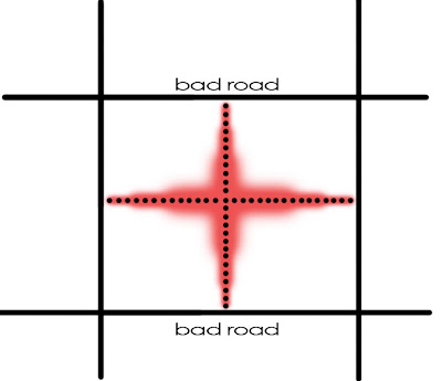
The last point is the one I want to dwell on the most because the type of street a retail store or restaurant is on, determines whether it can be considered a "hole in the wall" or not. By definition these are hard to find places, NOT on the main streets.

In Dallas, we almost have to create the types of streets that would typically house "holes-in-the-wall" as the retail destinations because the streets that move the most traffic are such hostile streets that they ONLY work as retail space if there is a full football field of surface parking buffering the store from the street. = Sociofugal space, which as I've said, age incredibly quickly.

As I type this Dallas appears to applying "streetscape beautification" to Elm Street, in the form of new bricks. I'm generally of the opinion that if a pig is a pig, it is better to not spend the money on the lipstick as the fundamental issue with why retail doesn't work on Elm or Commerce is that they are bad streets.

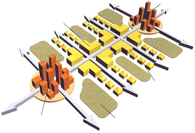
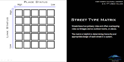
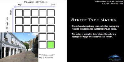
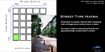
Retail wants to form at intersections. They are the highest visibility areas, with the most amount of movement happening in front of them.

As a place grows, it might link two retail "nodes" which then expand because of the increased synergy generated by the movement between the two (provided the distance is not too great).


This is how it might look in built form, with the most amount of density occuring where the most amount of activity would be, the busiest retail being at the ground floor of the orange buildings, and "holes-in-the-wall" finding their way into cheaper space somewhere in the yellow. They don't need the visibility because either quality is the determining factor in their business or they don't require the shear number of customers to support their business model (which generally means higher prices via higher quality).

This is taking advantage of the "movement economy". You can't just make this happen without designing appropriate streets however.


In Dallas, what we tend to to, is to create retail places off of the primary movement streets because, as I pointed out yesterday, we don't design streets to take advantage of all of the visibility and movement happening on them in a safe and beautiful manner because through some theology, an engineering text says what is up is down and what is left is right.

The fundamental problem is that this is limiting the success of the businesses and further limiting the potential quality of the neighborhoods, because commercial space wants to be on the busier streets with residential preferring the calmer, internal circulators.


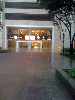
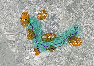
For example, I give two of the currently more active places in Dallas: West Village and Main Street/Stone Street Gardens. I plan on talking more about the specific design detail flaws of West Village another time, but the point is clear. The developers/architects knew they were dealing with hostile roads so the turned inward.


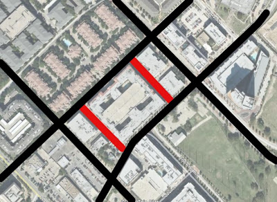
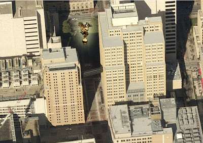
I've talked about Main Street before, but here is another diagram showing it between Elm and Commerce. Stone Street Gardens is a nice space now, but I would argue that despite Campisi's relative success, its vitality today is more due to its relationship to Main Street and that other than extremely nice lunch hours on weekdays that it can be pretty lonesome closer to Elm Street.


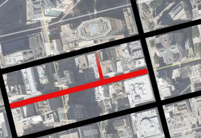
Nice days and the downtown daytime population provide the necessary density for a relative hole in the wall to work (as in a restaurant on a "street" with no vehicular traffic). But, for more retail success and downtown to work on the whole, it needs much greater density to support the night and weekend business as well. You know how frustrating it is to find an open restaurant on Sunday in Downtown Dallas?

But alas, this post isn't about what it takes to create that density (BALLS!) so much as it is about showing what indicators exist for downtowns that work. A couple of my favorite areas of cities have hole in the wall restaurants in areas you would never expect, and many times these are the best places to eat as the primary roads are taken up by conventional chains and tourist traps.

One of which obviously is New York which has holes in the wall all over the place. Last time I was there, we even found one of Bobby Flay's restaurants on a street that was little more than a service alley for some of the nearby hotels. No matter, quality and brand covered for lack of locational identity or prominence.

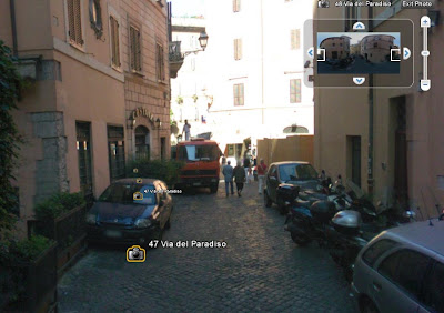
Below is the best restaurant I ate at in Rome (and most expensive). It didn't need much traffic and for a while, I didn't even realize it was a restaurant until doing some investigatory work. It has density and a residential base proximate to support its business (and assuming these google street views are relatively recent, the business looks as though it is doing just fine 8 years hence).


Lastly, is Old City Philadelphia. It is full of these little carriageways bifurcating city blocks defined by busier streets. Yes, the busier streets (particularly the intersections) attract the majority of bars, restaurants, and starbucks, but these tiny side streets are home to their fair share of businesses as well because their calm and attractive enough to house density to support such niche businesses in a manner that people want to be in.

Queen Village,PHiladelphia