Showing posts with label spatial integration. Show all posts

Monday, April 16, 2012

Moneyball for Cities

Alert: nerdy, wonky stuff herein. But, I can't resist. I find this stuff fascinating. Below are a series of maps creating using Space Syntax. Space syntax is a theory of urban design and planning sprouting via the convergence of mathematics, systemics, and cities. In many ways, it is urban planning coming full circle from Jane Jacobs, who essentially spawned complexity thinking as she introduced concepts of self-organization in relation to cities.

What space syntax does (and the variety of programs that operate it) is measure the complexity of the network. As the theory goes there is a direct relationship between the objective mathematical measure of complexity, the integration of networks (red is high, blue is low) with a variety of implications on the city including: resilience over time, pedestrian activity, land value, crime or lack thereof. In many ways it is an objective measure of predictability. Critical in both planning and real estate development. Vary the network and you will inevitably vary the system within and all that implies including land value, density, land use arrangement, and so on.

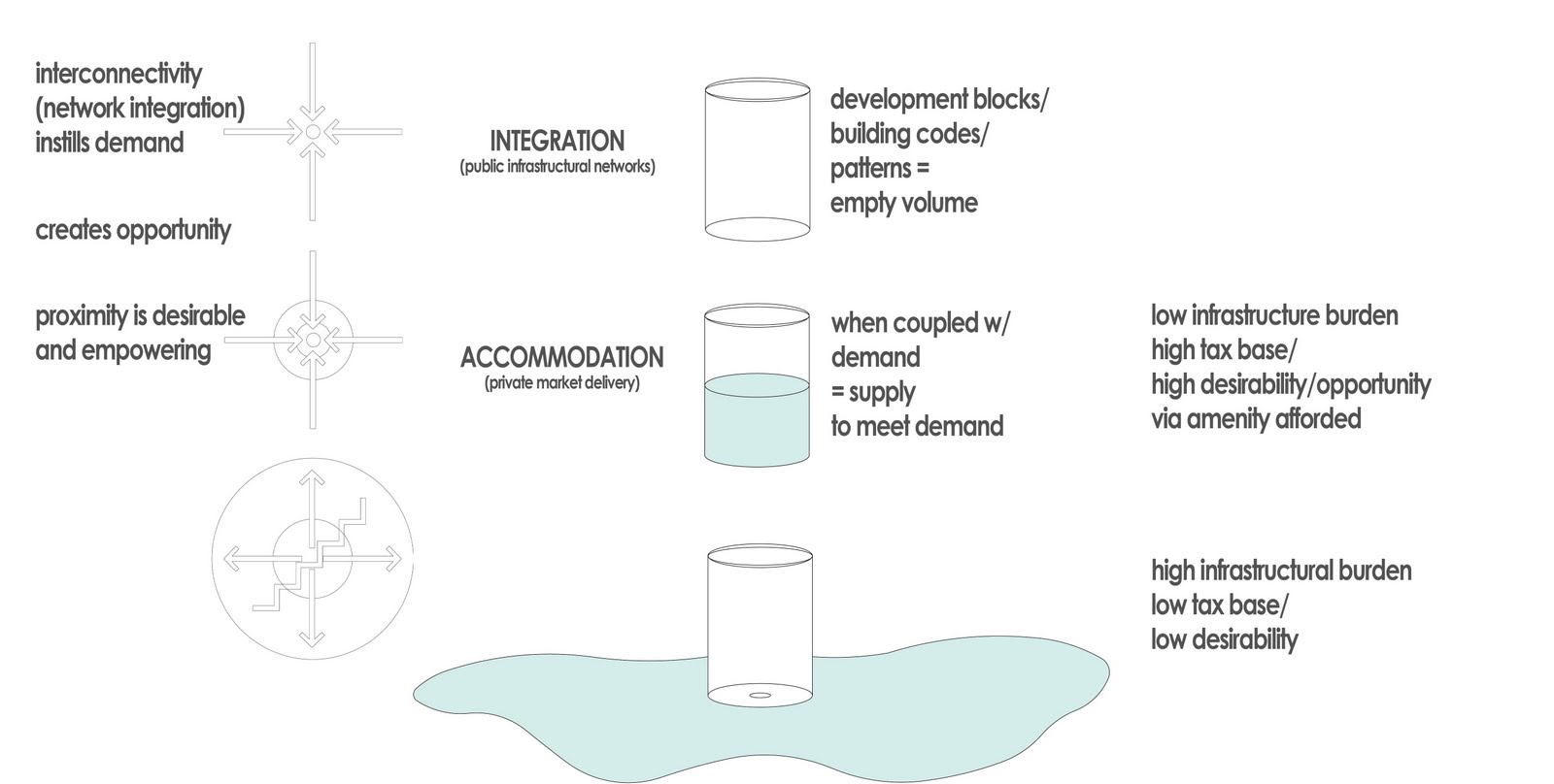
What is most interesting about this stuff however is that while it is entirely objective and quantitative, there is an implied qualitative component to it as well. As I often say, integration begets accommodation. Integration is the connection. Accommodation is what makes the place nicer. As Gil Penalosa presented to Dallas City Council, "it doesn't matter if it is nice (yet). All that matters is the integration of networks." By saying this, Penalosa implicitly understands that the connection is what drives value and the accommodation, or qualitative improvement of the place, is henceforth inevitable. An outgrowth of the underlying system.

Integrate networks and you get investment. Disintegrate networks and you get disinvestment. In terms of moneyball and mapping, this allows us to point out areas that may have too much investment and too much density based on the value of their spatial integration. These would be places where you either 1) wouldn't want to put your money into, or 2) can identify for network improvement to bring the spatial integration value UP to the value of the investment. Think of: Victory and LoMac, here. Lots of density (in terms of height and floor area), very little urbanism (as in spatial integration).

On the flip side, we can see areas of high integration and low value/density. When there are disconnects like these we can see opportunity areas. But first, we have to ask ourselves, what is wrong with those areas. And that is where more in depth local analysis is required. We'll get to a few examples of that below:

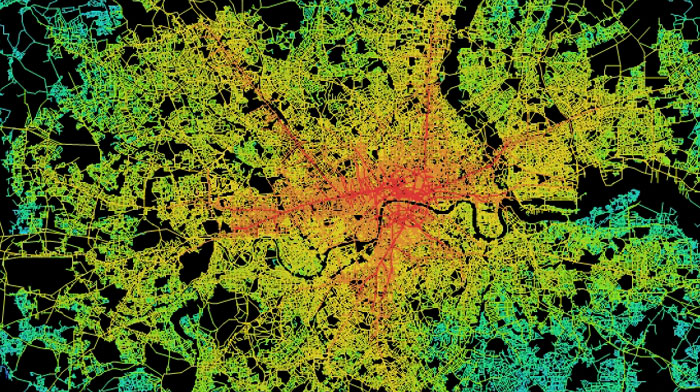
Space Syntax model of all of London.

If you squint your eyes enough, in abstract the city begins to look like this (above). There are two levels of hierarchy at work. What we might call the macro- and micro-hierarchies. Macros compete with macros. In this case, London vs. Dallas. The micro are competing amongst themselves within the system, ordering themselves from top to bottom. The top of the food chain being the most interconnected and therefore the most value.

Above is downtown Plano and vicinity. I also included the plan for the Richardson TOD plan if it were to be built out in full as planned just for funzies. As you'll notice, this is a bit less ordered than the London map. There are two primary and disparate reasons for this. One, London is a much older city that has had a thousand years to self-organize. Meanwhile, Plano is only a few decades old. Secondly, and similarly important, this is looking at a micro-scale whereas the map of London viewed the macro containing hundreds of these interdependent micro-systems. The order is easier to see at the macro-scale.

What is interesting about this Plano map is the "hottest" or most spatially integrated area is downtown Plano. Some of the least? Collin Creek Mall and Collin County Community College, which is arranged much like a conventional shopping mall.

The Plano map also includes DART in the network model, however it doesn't fully weigh its value unless you map the entire system (because it only connects regionally). The model above only sees the linkage from the Bush Tollway stop to downtown Plano to Parker station. And even then, the DART red line is one of the "hottest" or largest drivers of value within this map just behind 15th and K.

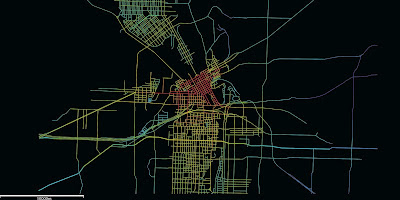
Downtown Richardson. I haven't progressed as far as with Plano, but the degree of disorder is even more prevalent. I suspect this is related to the current shape of the respective downtowns, Plano vs Richardson.

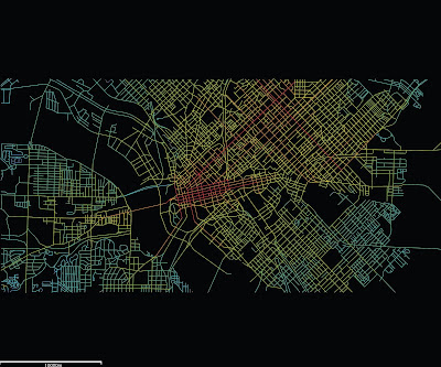
Here is downtown Dallas. Predictably, the Main Street core area glows the brightest. Two things also to notice: how surprising disconnected uptown is and how interconnected East Dallas is. There are a couple of explanations for this. One reason is the map I worked from. It is wider east-west than it is tall, N-S. This will invariably give more weight in the direction that the model thinks the city grew. Since it doesnt see the rest of Oak Lawn and North Dallas, this current model makes uptown look less interconnected than it really is.

However, there is some truth to that. Uptown, aside from the CityPlace/West Village area and to a lesser extent State-Thomas isn't that well integrated into its surroundings. It puts undo pressure on McKinney with little other choice of route. I interpret this to mean that the density and investment uptown has experienced is more due to its place within the macro-system than its particular spatial integration. Meaning, its current value is due to its proximity to downtown and its location between downtown and North Dallas (the favored quarter in Leinberger's terminology).

But, Near East Dallas shares a similar proximity to downtown. And it is better interconnected. While there has been some haphazard investment and land use intensification the Live Oak and Ross corridors remain tremendously underdeveloped given their potential. Unlike many parts of the city, this area seems to be the least encumbered by disconnecting elements (rivers, lakes, highways, railroads). In fact, it is one large contiguous area begging for investment between downtown and White Rock Lake.

Areas like these that the model sees as high value, but you know in fact to not live up to that potential are places ripe for investment. Except that investment typically has to be a concerted effort between the public and private sides. The private side is risk averse. It doesn't want to pioneer into an area if it won't be supported by the necessary public investment. The disconnection is usually from the public side. Something is wrong with the network. In the case of East Dallas, this is an infrastructural problem. A public realm that is not conducive to pedestrian activity, lack of quality choices for multi-modal transportation, as well as fragmented parcelization.

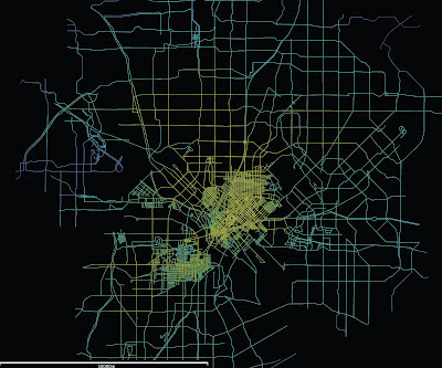
The above is the beginnings of a map of the entire city. As you can see there are no hot spots. Part of this is due to the incomplete nature of the map. It isn't seeing the full gradient from high to low. But this also pinpoints the issue plaguing downtown Dallas. Instead of red areas (high value, high density), the demand via spatial integration value is smeared across the city as no place is truly, highly interconnected and integrated, making density desirable, valuable, and predictably successful.

And above is downtown Fort Worth, which I thought I'd begin to put together for FortWorthology's interest. This still has quite a bit of work to do as well. Not just adding more of the grid in surrounding areas, but also de-linking the highways. Without doing so, it sees overpasses as interconnected when the roads are actually flying over each other. And by doing so, by making the "flow" of traffic less stop and start, we devalue the individual intersection, convergence points, and diminish the overall network of intersections. And therein lies the value of the city. Meeting points. Not bypasses.


Monday, April 2, 2012

Of Glass Boxes and Glass Slippers

One of the tragic things working in Dallas is the amount of people and effort trying to make things work, make the city more urban, ultimately giving it a longer shelf life, is that there are many smart people trying to make little changes within a fundamentally broken ship. Sardonically, we might call this rearranging deck chairs on the Titanic. However, we tide ourselves over with the comforting thought that a million (or only a dozen) small actions can lead to a tidal wave of change. The big changes to the underlying DNA of a place are just too difficult, too politically charged to even bother with, instead we'll just set the table, the linen, the silver, and the china on this one little dining table. So what the boat is headed for the iceberg of inevitability?

Perhaps neatly and accidentally summing this up is the news from the weekend that the City of Dallas, and in particular the parks department, is going to update the downtown parks masterplan. Buried within the subtext is a brief mention of two high-rises that are coming down to make room for new parks? New something. Probably not buildings. And if they are, they likely won't make money. Such is the state of downtown Dallas. Things happen by charity and subsidy because the transportation framework is stacked against downtown.
The glass is empty, so throw out the glass. Sure, the numbers don't work to fill that glass, but that isn't necessarily the fault of the glass, but the infrastructural network creating the hole in it instead.

I've been saying this for a while now, but the highest and best use for downtown land is nothing. Sad to say and sorry to challenge your world view, but this is inevitable within the broken system. Thus, within that system, we rationally think that nothing or a park is better than a building. That building is empty, so take it down, of course! Demand is too low to make anything work within that building. So instead of instilling demand, we reduce supply.

I forwarded this story to someone over the weekend who responded derisively, "let's just tear down all the buildings and make a wildlife safari." Or maybe move the zoo and let jungle cats roam the streets. Highest and best use: parks and parking. Perhaps it is time to admit we're doing it wrong and systemic reform is necessary to how we think about our city, cities in general, and the underlying processes behind urbanization (or in this case, anti-urbanization).

-------------

Along these lines, Robert Wilonsky, formerly of the Observer and now mainstream at the DMN -- but still working 24/7, sent along the news that the city is seeking an operator for their first 'glass box' retail space. The glass box semi-'popup' retail space is something born of the downtown 360 plan. It creates retail space in places that currently lack it. In essence, it is giving an interface to blank walls. However, there is a catch. There must be demand before supply.

It's not a terrible idea. In fact, it is a good one. But there is a slippery slope. Again. And that is if they are used willy nilly, then they are supply side urbanism and thus doomed to fail. For the city to erect these glass box buildings is good in a few ways: (1) it eliminates some startup costs (and barriers) for a small, local business to locate in downtown Dallas. (2) It provides an interface for a buildings currently lacking one, ie a front door engaging the public realm where currently there is none, a blank wall.

It is potentially bad if these are established in places where they won't succeed, in areas of low spatial integration. Spatial integration = demand = greater chance of success, the quick wins the city and the downtown 360 plan are looking for.

So, if we're looking for a quick win for the idea of the "glass box" in micro and downtown success in macro, you'd think we'd locate the first glass box in the location where it has the highest chance of success. Since there are several potential locations for the idea of laminated retail space on a current building facade, we have to pick the place that has the highest spatial integration value. Unfortunately, that isn't Browder Plaza. Yes, it needs it, but making this phase one is the right place at the wrong time. Or wrong place at the right time. Both suffice.


BrowderStreetPlaza.JPG
I too love theoretical people in renderings. But where do they keep their wallets? Is this how we visualize tourists? As apparitions, floating amongst us, the real and true Downtowners?

These people have to come from somewhere and that somewhere is through spatial integration. As I wrote about the McKinney Avenue Trolley last week, through movement is not nearly as important as cross movement because the people that cross the street are from the neighborhood, the street serves the neighborhood, and those are the people that populate the sidewalk and thus patronize businesses that interface with the street. Furthermore, these are return customers who keep businesses afloat.

I don't know all the decisions behind establishing the first glass box on Browder Street, a pedestrian plaza closed to car traffic, linking Elm and Jackson Streets. It very well could be that the city is trying to make retail work on Elm Street since it hasn't on its own. But that is part of the problem. It works on Main Street for a reason. There is a higher degree of integration on Main Street. Where Main and Akard meet at Pegasus Plaza is the crossroads of downtown. It is the single point of highest integration in all of downtown, its "Main & Main" corner.

There just so happens to be a perfect place on Pegasus Plaza as well:


As you can see above, the back of the Magnolia hotel fronts on Pegasus Plaza. Currently, this is a doggie dumping ground. I believe this is even a location picked out by the downtown 360 plan for retail lamination. Placing phase 1 here would build on the success already of Main Street rather than trying to expand that success beyond its natural boundaries. Those boundaries are Elm, Commerce, Field, and Ervay currently.

I'm the first to say we have to build outwards upon Main's success, but that can't be done without addressing Elm and Commerce's natural barrier effect. Much like rivers can't be crossed without fords or bridges, a river of cars is also a barrier to crossing, thus decreasing spatial integration. Meaning less pedestrians, less value.

City has added brick to the sidewalks on Commerce, but has spent nor done anything to actually change the functionality, the integration, of the street. The street is not narrowed, calmed, nor slowed. A center of gravity is not made. It is simply an aesthetic treatment, ie the least important thing you can do if you're really, really trying to catalyze change. Along those lines with the RFQ, the city is spending $500K to pretty up the concrete heavy Browder Plaza. Again, as with all superficial treatments, without first upping the degree of integration, cost significantly outweighs returns.

Now it could be that Commerce is ready for something there, but it is a gamble. Not the sure thing, nor quick win it is being espoused as. This may be a timing issue in conjunction with Forest City delivering more units further down Commerce, however the gravitational pull will remain Main Street as long as Elm and Commerce exist as they do, as escape routes. Places to save time rather than spend time.

The second problem here, is that there is a good chance this is the city picking and choosing winners. I'm no fundamentalist libertarian, but it is rarely a good thing. The public agency is better off focusing on instilling demand through the establishment of a transportation network that is about clustering. That is about demand, rather than about moving people out. Rather than instilling demand, the city is adding supply of new restaurants by funding the startup costs in essence within an area that is likely maxed out on restaurant/entertainment/retail space.

I have no data, just experience living in downtown, but I get the sense that the integration increment DART added to downtown has maxed out. Downtown is what it is now, rather than what it was nearly dead in 2000, because of DART. If we are indeed maxed out, new retail space cannibalizes from existing retail space. From living and being in downtown every day, and experiencing the evolution, it certainly seems like what is happening. One new place opens, another closes.

All of these issues, point towards an economic development program that is better aligned with urban design, and vice versa. I get the sense that they are aligned, just misguided currently. Integration begets accommodation (and decoration). Merely adding accommodation (and decoration) via a variety of incentive packages is spending to get minor successes. The solution is right in many ways, but the superficiality, the supply-sidedness of it, undermines the effort towards quick wins.

Alas, the glass slipper is still just a pumpkin.

Post Script:

Big Jon Daniel asked on twitter if this is a shot by the city "across the bow of food trucks." I don't think that is it at all. In fact, one of the food truck operators would probably be an ideal operator for the first (or any subsequent) glass boxes. Food trucks started because of the reduced startup costs in conjunction with the poor locational efficiency of the majority of the city. Simply put, entrepreneurs couldn't locate in the appropriate spots due to a variety of cost barriers, both real estate and operational.

Speaking for the food trucks, I would expect some would like to grow and expand their business. Many would like to grow up and have ambitions of a permanent establishment. If one of the food trucks moved in to the glass box, that would allow the laminated retail space to operate as a supply depot for the truck. At night, it could even park adjacent along the street and create a little cluster effect between the restaurant and the truck (particularly if the two filled separate culinary niches). Of course, that would mean parking on Commerce Street, altering its traffic flow patterns (God forbid!) and thus, another good idea dies a premature death.


Wednesday, January 25, 2012

Why Are Skylines Roughly Conical?

I want to take a graphic look at some concepts I've been developing lately, in conjunction of course with the work it builds upon, including the Bartlett School at the University College of London and their work on mathematical models of spatial integration as well as the Andres and Douglas Duany codeveloped concept of the transect.

Spatial integration began as a scientific examination searching for objective realities to urbanism. Why were cities and their patterns so similar? Where and when have we begun to go wrong? And is the aesthetic, subjective driven world of Modernist architecture partially to blame?

Completely independent of this work, the Duany brothers saw similarities in the gradient of intensification of cities as you got closer to the core with various ecologies, particularly coastal regions:


This, became this:


Both relied, perhaps intuitively on the concept of centrality, which has its origins in the study of social networks. Since cities are the physical platform for social and economic exchange, empowering the links between them, network studies had direct relevance. Cities are networks.
But the Transect never really digs into why what was where. Sure there is a dense node at the center, with an decreasing gradient the further you get away from it. But what created centers in the first place? That is where space syntax began examining infrastructural networks. Professor Bill Hillier and his pupils/colleagues found a correlation between social network analysis and infrastructural networks. That is, social hubs have the most connections. The highest degree of integration. Likewise, this parallels with the internet. The highest trafficked sites are hubs that all others link to. Think Google. From there exists a hierarchy from most to least.

Likewise, cities have a similar hierarchy. The most connected places, have the highest degree of integration, which in turn means the highest degree of opportunity. Where there exists the greatest demand, to which the market responds with supply. Building space. Where demand is greater than supply exists the most opportunity for developers. Where integration is highest is the most opportunity for every citizen to meet their needs for social and economic exchange.

This concept exists locally, within one city, as well as globally, amongst all cities. New York, London, Tokyo, Paris, etc., are global cities because they are the most connected, both locally and globally. Within a single city, you also have a hierarchy of centers. All cities are polycentric once they get above the scale of the tiniest of hamlets. This is what sprawl apologist hacks like Joel Kotkin fail to understand. When they talk of polycentric, sprawl-based cities as polycentric cities of the future, they fail to see that New York is also polycentric. Those centers just blur together rather seamlessly, except where geographic barriers (water bodies) or physical barriers (such as highways) divide and isolate them.

Space Syntax map of London:

What they found was that there is a correlation between traffic and value. Just like with any network, particularly the web. The most trafficked sites have the most value. Remember that traffic doesn't mean cars, but people. This is a direct relationship in what I call logical cities. High pedestrian areas have far more people moving past, and capable of interacting with you (economically or socially) in these high traffic areas than does car-based traffic, which has to turn, wait for lights, find parking, etc., all of which accounts for increasing degrees of disconnection, dislocation, and inflexibility.

In the logical city, such as the London-based map above, there is another chicken/egg based component to it as with all complex, interconnected systems. The infrastructure funnels traffic to specific places and specific places also "bend" the infrastructure to them. This is why I call them centers of gravity, what many planner types call "nodes". They literally shape the city around them. Increasing their level of interconnectivity, raising demand, and eventually via opportunity, supply.

Because of the chicken/egg scenario, this also means that infrastructure can create places out of thin air, such as when two railroads meet in the midwest. The traffic intersection becomes an opportunity. And many cities are here today because of such a phenomenon. I'll look at that a little more later.

But first, here are several skylines:
While this is Dallas and the exercise is admittedly abstract, I want to show why downtowns have the biggest buildings. And why severing the interconnectivity to them, is why many of Dallas's buildings in downtown are quite empty, for example. As I have written before, Dallas experienced a building boom (high-rises) at the exact same time that the city, state, and federal level were gorging on highway building. Supply was being added while demand was being undercut, shipped out towards the suburbs.

Those polycenters, instead of being closely interconnected, became Las Colinas and the various highway adjacent corporate office parks around the metroplex. That they were newer or the space is better and they are "grade A" office is irrelevant. The newer development would be in and around more walkable, more highly integrated and interconnected places (more authentic places). They would also prove to be more resilient. I expect, unless they drastically reposition themselves, many of these office parks will fade into dust. With new light rail (another degree of interconnection) and residential, Las Colinas is already doing that.

Compare our growth to say, L'Eixample neighborhoods in Barcelona and Valencia. These were rapidly expanding areas, literally doubling city size, but they did so aggregately. These are both now considered the "old money" areas of those particular cities, and very much still central city as growth then enveloped them.


The dynamic changes a bit for cities like Paris or Washington, D.C. Both cities with extremely high levels of integration, locally and globally. Remember, that local integration is the foundation from which density and resilience lie upon. The most connections can be made locally in dense, walkable environments.
Because the level of integration is so, demand is extremely high to be in the center of Paris (or D.C.). But height restrictions limit the amount of supply of usable building space, making prices skyrocket. The center of Paris is amazing. Who doesn't love it? But it also leads to this condition where opportunity then shifts outward, toward the Banlieus, or suburbs:
The supply is much greater than the demand, which is to be actually in Paris where opportunity is high. But it the market can't meet the demand, so it spills outward. Too much supply, with too low levels of integration. There isn't a natural, organic match. This is made even worse with the design of the "towers in the park" housing for the poor. Whether they were built for the poor or not, eventually they were doomed to devolve because of supply being much greater than the demand. These types of Corbusien buildings are physically isolating, cul-de-sacs in the sky. In effect, the supply is borrowed from the areas with higher integration, higher value. Not coincidentally, these are the areas where Paris experiences the most civil unrest, in homogenous areas of poverty exemplified by socio-economic isolation. Isolation. As in not integrated.

However, this is not to say whether Paris or DC's restriction on building height is wrong. That is a political debate. In my estimation, these cities heights or lackthereof is precisely what makes them so special. 1) The building heights remain humane, lower to the street level, and more interactive. And perhaps more importantly, 2) the demand pressure exerted upon a limited supply ensures that the limited space will always, ALWAYS be maximized. And buildings will be preserved rather than destroyed.

The real issue is improving the connectivity, integration, and walkability within and to the suburbs. Here is where I shift in language from banlieus to suburbs because the need is universal. American suburbs may not have many, if any, high-rises, but supply is currently way above demand, as defined by spatial integration values. Values are plummeting across the country, not only because of the evaporation of liquidity (real or imagined), but also a general market realization and price correction towards this supply/demand imbalance.

There is a movement afoot to "retrofit suburbs." While there is certainly opportunity to do this, and a necessity in many cases. I'm afraid that while some areas will be fine, some will need salvaging, while others are fairly doomed. We simply won't have the capability of retrofitting ALL of them. And by retrofitting, I mean increasing their local connectivity/integration quotient to instill, increase the demand to catalyze the new infill that the retrofitters propose. There will be extreme levels of competition and upheaval, I expect, in American suburbs.

As for city growth:

As I mentioned earlier, it all starts with an intersection. This could be anything:

Two railroads crossing
Two ancient trade routes
Fertile soil and a deep water port

The connection globally has to be strong enough to maintain the raison d'etre. The local connections, like walkability, ensure that the place is efficient and livable. And that people like living there as opposed to the competitors. It is also important to note that no cities current place within the hierarchy is the place it will reside in 10-, 20-, 50-, or 1000-years. Such is the competition amongst cities. And such is the need to maximize local and global connectivity, as well as the raison d'etre for that city, whether it be energy production, idea production, or a socially vibrant place. Whatever it is, it better be timeless. See: Detroit, autos. West Texas, exhausted oil wells. Heterogeny ensures timelessness. Or something approaching it.

Here is the intersection. Imagine it is any of the aforementioned. The red implies the neighborhood development.


If the raison d'etre is strong enough, its opportunity level persists. It attracts more people. The city expands, aggregates:


Eventually, maybe it grows to the point where it needs more global connections. And as technology advances, the infrastructure is needed for those global connections, such as an airport and an interstate. However, all global movement is destructive to fragile local interconnections. Highways and airports can have negative effects upon overall interconnectivity despite increasing global connectivity. Local connectivity drops, therefore demand drops, therefore desirability and opportunity drop and eventually people will leave that city. That is why these global infrastructural networks must be treated very carefully, connecting with cities tangentially.

Vancouver didn't allow freeways into their city. Paris is removing all of them inside the peripherique. They're connected to their airports via subway. Subways are built because at-grade and above grade tracks are disconnective. Below grade is supremely expensive, but as all cities who have them have found, worth the high initial cost to preserve the fabric above.


And within those overall connections, smaller nodes or centers of gravity will emerge at the various convergence points. That is, only in the logical city. In the illogical city, where connections are disruptive and diminish overall connectivity and the ability of its citizens to meet their social and economic needs for exchange, a tension is created. The tension is two countervailing forces. That towards traffic, ie traffic = value. And the opposite force is the repulsive nature of those global connections, ie highways and airports.


You may have to click on the below image to expand it. It's one I've been working on to explain this concept. At the top left we have attractive nature of convergence. People create infrastructure to create opportunities for social and economic exchange, meeting points, trading places, markets. When you disrupt that network, you shift the magnetism so to speak, like putting two like poles of magnets next two each other.


When you look to the right diagram, the glass is supply of building form. The demand is liquid. When you interrupt local connectivity and overall integration (often for the sake of global connectivity), you are essentially creating a hole in the glass. All of the demand spills outward. You get sprawl and an empty glass. Like downtown Dallas highrises.