Showing posts with label Those EXTERNALIZED Costs. Show all posts

Monday, May 3, 2010

Monday Linkages

In honor of the South coast of these very States united being caked in the sweet nougat of the planetary bon bon, we're going to focus on some of the costs associated and/or externalized in the combustible economy built on happy motoring.

This is about a month old, but Carol Coletta of CEOsForCities interviews Anne Lutz Fernandez author of CarJacked on Smart City Radio. Anne talks of all the usual subjects regarding the high cost of car ownership, but particularly with regard to the poor and the high percentage of their incomes get spent on car maintenance/operation for cars that are often not safe or reliable on the roads. So in a way, they are much more expensive on several levels. Also, she discusses the exploitation of the vacuous notion of the American Dream by auto manufacturers.
--------------------------------
Happening as I type this, David Roberts of Grist is tweeting from the Moving Ahead 2010 conference, which is all about sustainable transportation solutions for the 21st century. A sampling:
Bill Lind (conservative!) openly advocates for raising gas taxes every year. He's more progressive than the Obama admin. Sigh. #ma2010

Bill Lind: streetcars are pedestrian facilitators. Losing streetcars was instrumental in decline of street life in cities. #ma2010
-----------------------------------------
Treehugger wonders what effect rising prices due to supply and demand inherent in peak oil and its potential for softening the landing due to decreased usage.
None of the above is intended to suggest that the market will fix everything. Or that peak oil is anything but a major concern. It undoubtedly poses a threat to our stability and well-being, and could even cause social disruption and unrest. Throw climate change into the mix, and the future is anyone's guess. But as I argued in my post on why activism beats prophecy every time, predicting the future is a fool's game. We are much better off figuring out what kind of future we want to see, and then making it happen.
---------------------------------------
On a related note, over the weekend I heard of a report suggesting that the true price of gasoline per gallon is closer to $15 rather than the $3 or whatever it is at the pump when you factor in all of the externalized costs, effects, and subsidies associated. So I looked it up and here it is, written and published in 1999, Real Price of Gasoline by International Center for Technology Assessment.
--------------------------------------
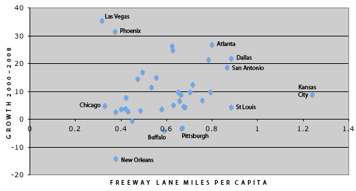
Another (and more recent) report wonders why we keep building new roads when we can maintain the crumbling existing infrastructure:
Road Work Ahead describes how America’s roads and bridges are in disrepair, bringing together a wide variety of statistics and sources with state-by-state analysis. It shows how special interest pressure tilts the playing field toward the construction of new and ever-wider highways at the expense of repair and maintenance.
------------------------------------
The trouble with livability rankings and the disclosure of the data and metrics at WSJ. Where one list has Vancouver as its most livable city, another Vienna, and even another...Huntsville, Alabama. Where is that number for Uhaul when you need it?

Livable-city rankings can be misleading even when the methods used are transparent. The differences between the first- and second-place cities on these lists are so minute as to be statistically insignificant, yet Vancouver and Vienna get the bragging rights for first-place scores. Even a 56th-place finisher like New York scored 87 points, according to the EIU, which still places it comfortably in the top tier of cities.

"Generally speaking, we can see the figures look right," says Jon Copestake, editor of the EIU survey. "People in New York may argue it's a great city, better than Vancouver."

A recent New York Magazine ranking of top neighborhoods overcame a common drawback of rankings—that outlier results can have disproportionate impact on the overall results.

The magazine's ranking was accompanied by an online tool allowing readers to adjust weightings according to personal priorities and preferences. "We're giving you our expert authority on what makes a great neighborhood, and then we are sacrificing our authority and letting readers make their own call," says Jon Steinberg, a senior editor at New York who worked on the rankings. "We're kind of having it both ways."

Wednesday, February 10, 2010

Transportation Choice and City Building to Accommodate It

It's the dolla dolla bills y'all. First, a semi- book review:
--------------------------------
Last week, I destroyed Game Change in about three days, which does read occasionally like the hysterics of equally happy and jilted junior staffers aimed at their either current or former bosses. One thing that struck the biggest nerve with yours truly, was the level at which the old guard didn't or couldn't grasp the irresistible force that was the Obama Express '08, next stop White House.

This was particularly mentioned with regards to the Clintons and in a specific case with his eventual running mate, Joe Biden, with regards to Obama's proposed tax policy. Biden exclaimed, "that's it?! THAT is your tax policy?!" with pronounced bewilderment toward the seeming simplicity of it (the book didn't go into any explanation with regards to the two men's policy differences). To Biden, it seemed like nothing more than hollow rhetoric.

This is something that I've seen at every level of government throughout the country, and IMO why we see so much backlash towards bureaucracy and the unnecessary complexities of government. Each particular level of government at the leadership level was too involved in the minutiae, when they really should be up at the proverbial 10,000 foot level offering direction, but little in the way of detailed policy.

This is particularly true when it comes to planning, zoning, review boards, and city councils. Too many city councils are worried about every detail of every property, when they should really be focusing on simplifying and streamlining their own zoning documents. If you don't think the overwhelming complexity of city planning and zoning is a deterrent to real estate development, check your local 500- to 1000-page zoning document.

Set the goals, let your departments worry about administration, and focus on steering the ship.

At some level, I believe Obama gets that. His policies don't have the depth that lifetime policy-makers and wonks expect, because they...well, don't. Nor should they. This is the kind of simplified, tangled bureaucracy-cutting directive that this country needs, and all levels of government should take heed.

The lifers don't get it simply because Obama is the leader of an entirely new generation; a new phenotype if Howard Bloom is to believed. Millennials think differently than the previous world changing generation that has preceded them, the Baby Boomers. It is no coincidence that Millennials went 66-31 for Obama and that they made up much of his campaign staff, including his still executive speech writer.
------------------------------------

Like government bureaucracy, mathematics can be similarly complicated and confounding. Especially when you consider that our lives for the past fifty plus years have been defined and controlled by equations that are incomplete. By this, I'm referring to all those things that were determined to be too subjective to appropriately assess the value of, so they were in turn, left out. Who needs clean water, clean air, quality of life, etc.

Before such hysterical rationality dictated our lives, a politician once declared that the citizens of his city demand two things: Justice and Beauty. This is what we call, a pattern. A simple guiding principle, establishing a hierarchical decision-making process that empowers each level of the chain.

--------------------------------

Cities are often also thought to be complex. Perhaps this is only so, because no mathematical equation has been able to accurately assess or predict a city, other than to simplify a city into its component processes. What if rather than looking for more complex equations, we start thinking simpler? The water bodies of the planet are infinitely complex in their physical permutations, but the defining equation is that all water seeks to find its own level, and gravity does the rest.

My recent post last week took recent examples of theft in downtown Dallas and extrapolated it to a larger issue, the requirement of all to own and maintain a car in order to participate in what we call civilized society. I suggested that some incremental measure of crime and despair is driven by the lack of mobility or choice in transportation. If we had a similar directive to assess problems and affect decision-making like "Justice and Beauty," how much better off could we be (this makes the assumption that available lifestyle choice, in particular mobility, is a form of justice).

In the previous post, I referenced a study showing that more walkable cities can have car ownership per household rates at or near 50%, whereas Dallas finds itself at 10%. A new study referenced by the New Republic and conducted by Universities of Alabama and Florida (who knew they could cooperate?), states that residents of walkable communities save 16% of their income compared to those in non-walkable environs. Residents in walkable communities have a choice: they can have a care, if they so choose. The report goes on to suggest that this costs the nation trillions of dollars spent because of a lack of walkable communities providing adequate choice.

We know Dallas would look much differently if it were to approach a 50% car ownership rate, but how would it affect the local economy? Applying that % of $ savings number to two hypothetical cities of 1 million people, we will calculate the implications.

First, in order to compare apples to apples we need to define our variables and controls. The variable will be the rate of car-ownership per household, city A will be 90% and city B will be 50%. While these car-ownership rates would likely have drastic effect on spatial organization and, in turn, real estate values, we will for the time being ignore those differences (ahhh, too complex!!!).

The controls will consist of population size of 1 million, household size we will use 4, meaning # of households is 250,000, median income of 50,000 per household (if for no other reason than being a round number), while the report mentioned above used 16% as savings for walkable vs. sprawl, we will use 20% because that report makes no distinction for car-free which then averages and dilutes the savings.

Oh, and one last control: people are people. If you are the type of person that says, "shutup we love our cars u no good yella nazi hippie commie jerk." I am applying a system where choice is part of the equation. You are transferring your personal preferences onto everyone else in that system.

If everyone felt like you, the car ownership rate wouldn't vary so much and so predictably based on city form. City form is driven by transportation expenditures. Car ownership is a by-product of that, one whose machinations were too big and unwieldy to appropriately apply the breaks to a downhill-rolling snowball. So give up the phony-libertarianism. Your lifestyle is exceptionally defined by top down measures.

Now that I got that off of my chest, onto the back of the envelope (literally) calculations:

City A: 1,000,000 people
Households: 250,000
Car Ownership Rate: 50% (walkable city rate)
Households w/ Cars: 125,000
Households w/o Cars: 125,000
Median income: 50,000
w/Cars adjusted income minus transpo costs: 30,000
w/o Cars adjusted income minus transpo costs: 40,000
w/ Cars aggregate income: $3.75 billion
w/o Cars aggregate income: $5 billion
That is a total of $8.75 billion in income, transportation adjusted, assuming that excess transpo costs largely leave the local community by way of oil, gas, car, etc.

City B: 1,000,000 people
Households: 250,000
Car Ownership Rate: 90% (Dallas rate)
Households w/ Cars: 225,000
Households w/o Cars: 25,000
Median income: 50,000
w/Cars adjusted income minus transpo costs: 30,000
w/o Cars adjusted income minus transpo costs: 40,000
w/ Cars aggregate income: $6.75 billion
w/o Cars aggregate income: $1 billion
That is a total of $7.75 billion in income, transportation adjusted, assuming that excess transpo costs largely leave the local community by way of oil, gas, car, etc.

The difference between the two is that the more walkable city maintains $1 billion per year within the local community. Because it is local and largely discretionary, it often translates into housing costs, which is why you see higher housing costs in each of the more walkable cities shown in the study referenced. This directly counters Joel Kotkin's assertion that cities should be measured on affordability.
---------------------------------------
Furthermore, cities built around the car have to provide greater infrastructure to support the excess stress cars place on the city. Ahh, the multiplier effect. Here is where the numbers really get crazy:

City A population: 1,000,000
City A freeway miles per 1,000 people: .564
Freeway lane miles: 564

City B population: 1,000,000
City B freeway miles per 1,000 people: 1.291
Freeway lane miles: 1,291

With land acquisition, design, and construction, an inner city freeway can cost upwards of $100,000,000 /mile.

City A freeway cost: $56.4 Billion
City B freeway cost: $129.1 Billion
-----------------------------------------
How about all that parking. If we take the required parking for a car-oriented city like LA and that of San Francisco, we can begin to calculate the cost of parking on a city. Taking Professor Donald Shoup at his word, each car in America has at least 4 parking spots provided for it. Also, he has stated that San Francisco's required parking rate is 50x less than LAs. Let's also assume that each home that chooses to have a car has 2 and that the average parking spot costs $5,000 (not including spatial dislocation costs).

City A households: 250,000
City A households w/ cars: 125,000
City A cars: 250,000

City B households: 250,000
City B households w/ cars: 225,000
City B cars: 450,000

Even though the walkable city will typically have a lower parking ratio, to keep things somewhat similar, let's just assume both provide 4/car.

City A parking spaces: 1,000,000
City B parking spaces: 1,800,000
City A cost for parking: $5,000,000
City B cost for parking: $9,000,000

Total cost savings in walkable city of 1,000,000:

Income multiplied over earning period of 40 years:
$40 Billion

Highway savings:
$72.7 Billion

Parking savings:
$4 Billion

I just identified $116.7 billion in savings for a local community that chooses walkability to define its future. Now THAT is green. Of course, this doesn't even begin to scratch what Harvard economics professor Ed Glaeser has defined as the role of cities in the future economy:
"the economy is different now. It no longer revolves around simply making and moving things. Instead, it depends on generating and transporting ideas. The places that thrive today are those with the highest velocity of ideas, the highest density of talented and creative people, the highest rate of metabolism. Velocity and density are not words that many people use when describing the suburbs. The economy is driven by key urban areas; a different geography is required."
Density. Density can only be made livable through walkable design. Cars and their infrastructure are an unnecessary and costly barrier, a tax, to the free exchange of ideas in the new economy.


Thursday, January 21, 2010

Propinquity: the Distance of Stuff

I first heard the term in a meeting with Alex Krieger, who had on a pretty killer figure ground tie. I was not jealous enough however to realize that this man just used a word that I had no idea what it meant. I'm not going to lie. I had to look it up. Of course, when my sister taught me to read as a youngster and I came to a word I didn't know, she said, "look it up. And, don't talk to me you toe-headed brat." So it was nothing unusual.

Anywho, in the previous post I suggested that I wrote about walkscore and the difference between quality of walkable environ and proximity, which is what WalkScore measures. I found it in the archives of a professional discussion list:

One of economist Herman Daly's fundamental critiques of neo-classical economics is the valuation system. Somewhere along the lines, emotionality was stripped from economics because it encountered things that couldn't be quantified. So in our hyper-rational, Descartian world, things like happiness, clean air, clean water, and anything else that one might deem subjective or that couldn't be assigned a defined value were "externalized." Which essentially means we are making decisions without any of the factors that went into city building in the first place.

Statistics are slowly catching up to the to complexity of urbanism, although comparative value seems pretty logical. "Hmm, real estate in Paris and Manhattan is deemed valuable based on demand. Something must be right there."

Things like WalkScore are showing that there is a premium for what we do in applying the principles of urbanism based on an increment of their calculations. WalkScore, like any statistic is able to measure the quantitative but not the qualitative. In this case, proximity, but there is no score for the quality of the pedestrian environment.

You can point to walkability as a fundamental basis for economic development, or the qualitative improvement over the existing. The detailed physical design then addresses that which can't be measured, things that might be more visceral, like pedestrian pleasure.

Backing up to WalkScore and proximity though...what I'm discovering, is that if you think about it on purely economic terms, the distance between consumer and transaction is a barrier, where tax dollars for extensive transportation networks, car companies, mechanics, gas and oil companies, etc etc, all take their little slice of every single transaction in a world where everyone has to drive to each interaction as the cost of delivering goods/services to the consumer in demand is also externalized to the consumer. How often does the average consumer think about that when they are thinking about the price of milk?

We all know that previous policies have spread people too far apart. What happens then, particularly in the Sun Belt and similar cities where "Drive Til You Qualify" is rampant and there are very few affordable places to live near transit or in walkable communities, the poor in many cases then are excluded and disenfranchised from the economy, in some cases spending as much as 40% of their net income on transportation, just to participate and make ends meet. Hardly, a way to generate wealth and "pick themselves up by their bootstraps."

Damn, Imaginary People Saving More Loot Than Me

Via AlexSteffen at WorldChanging comes this study on cost savings for going Car-Free by City at the American Public Transportation Association:

Top Twenty Cities - Transit Savings Report


City Monthly Savings Annual Savings
1 New York $ 1,147 $ 13,765
2 Boston $ 1,030 $ 12,362
3 San Francisco $ 1,013 $ 12,156
4 Chicago $ 946 $ 11,357
5 Seattle $ 932 $ 11,185
6 Philadelphia $ 927 $ 11,121
7 Honolulu $ 887 $ 10,639
8 Los Angeles $ 838 $ 10,052
9 San Diego $ 824 $ 9,894
10 Minneapolis $ 824 $ 9,884
11 Cleveland $ 803 $ 9,639
12 Portland $ 798 $ 9,581
13 Denver $ 795 $ 9,539
14 Baltimore $ 782 $ 9,383
15 Miami $ 752 $ 9,022
16 Washington, DC $ 751 $ 9,015
17 Dallas $730 $ 8,756
18 Atlanta $722 $ 8,658
19 Las Vegas $716 $ 8,591
20 Pittsburgh $ 680 $ 8,162

*Based on gasoline prices as reported by AAA on 1/11/10.

I'm guessing that they had to use pretty basic and standardized numbers to calculate this by city without too many variables. I made my own calculations when I first ditched the car and moved downtown here.

The first thing you'll notice (besides my old car - pictured) is that their calculated savings for car-free living in Dallas come to $8,756/yr whereas mine were/are $6,660/yr. So what's with the disparity?

First, I'm guessing since that I'm on the ground doing it, my numbers are probably a bit more accurate (and I don't even keep a monthly or yearly DART pass - although late night cab rides might balance that out).

Second, and this is where local conditions of supply and demand would skew the entire list of numbers (and this will blow your mind). Because Sun Belt cities have much less supply or opportunity for walkable neighborhoods (and are less adapted to their fledgling transit systems), the housing cost differential would show a greater disparity in Sun Belt cities than more walkable cities. Notice the top four consist of NYC, Chicago, Boston, and San Fran. The only two other cities as walkable/transit friendly are DC and Portland (I'll try to rationalize those two outliers later).

What I wrote then is that to live in Downtown Dallas, where I have access to DART, trolley, Amtrak, rental cars, grocery stores, and bars (the most important, of course) within walking distance, I figured that I am paying at least a 20% premium to live in a walkable/transit-friendly neighborhood, or $2,520/yr. That number is pretty close to the gap between our calculations, which was $2,094.

Chris Leinberger talks of premiums for walkable communities on a per sq.ft. basis being between 40 and 200%. While certainly there is some increment to the quality of that walkability (see my critique of walkscore. The gist was that while walkability does measure proximity and correlated propinquity, it does not measure more subjective or visceral quality of experience), the point is that there is most definitely a premium for walkable places.

However, I would suggest that in cities of increased supply of housing in walkable communities, which has an overall increase in cost of living (b/c of the demand by more people wanting to live in what is typically a more interesting and vital city), the discrepancy in cost between walkable and not walkable is not as great, meaning there is more choice in the market place. In the Sun Belt cities, such as Dallas, savings for going car-free or therefore reduced, b/c you are paying more due to pent up demand (Leinberger suggests that 30-40% of populous desire walkable communities but only 3% have them) driving up costs.

What this means for Dallas, is well, the need to focus on livability of the City's design and function through walkability. Thus, making walkable communities more affordable and available as a choice to a broader base of the population. This will allow more families and individuals to either save, invest, or spend through increased disposable income as they see fit.

Choose walkability. It's the democratic thing to do and will ignite the local economy.

Of course, no one wants to walk under an overpass.

--------------------------------------

Tuesday, June 30, 2009

Fun with Numbers/Dallas Budget

So in light of the City of Dallas experiencing a nearly $200 million dollar budget deficit, I thought I would have a little fun with numbers while we watch education, police, fire, and presumably every other necessary service get slashed while road maintenance and upkeep retain highest priority.

First of all, I should say that compared to many other cities that I have been to and worked in, Dallas is getting off light. The city is both lucky and unlucky given its defined boundaries. Many smaller cities are experiencing much more severe budgetary constraints. For example, one city of approximately 100,000 had a projected shortfall of $250,000,000 equalling $2,688 per person. And THAT number was strictly for infrastructural upkeep and maintenance (and upgrades. Can't forget upgrayddes. That's how I will spell it from now on whenever an engineer uses the term road improvements or upgrayddes because it is such a bastardization of terminology), meaning no new construction. Compare that number to $146 per person in Dallas. That's nearly 20x.

Building low density sprawl had come home to roost. We simply can't afford the level of infrastructure that sprawl expects. The primary issue is that logically and throughout history level of services and amenities increased with greater density. It makes sense, more people sharing burdens and costs, the more can be achieved with that pooled wealth. The countryside couldn't afford sewer and roads and power, etc.

This is why I state over and over that Deep Sustainability comes in two forms, self-sufficient and very sparse (the Jeffersonian Ideal) or the very dense cities (but I expect due to material constraints this means lower scaled, but still dense building in the model of Florence, for example). As we know, the very necessitation of human settlement patterns (and community) is shared common hardships and then, in turn, quality of life improvements through gains in standard of living brought about by the economics of sharing, trading, cooperation, markets, etc.

This pattern can be traced directly to Maslow's hierarchy of needs. Imagine ourselves as lonely neanderthals at the bottom of the pyramid, rising to the highest of levels during times such as the Renaissance, or the Enlightenment, or the even the technological revolution of today leading to increased levels of interconnectivity. And then crash back down to the yellow in our fractured and disconnected society via the car, the television, etc.


With out new found wealth and suburban explosion, we expected the best schools and similar level of infrastructural support to follow. For a time it worked, but upkeep has proven to be the problem. The infrastructure and population density are spread so thin that we put so much pressure on such brittle apparatus that it begins to collapse due to overuse often caused by our dendritic arterial system versus a more choice-laden, adaptable and dispersive grid network and underfunding.

So getting back to why the City of Dallas's budget shortfall is 20x less than that of smaller cities as discussed earlier, Dallas is lucky in that it is landlocked by its suburban neighbors. Dallas proper can do very little in the way of new growth, which has mostly happened in areas like Rockwall, Mansfield, and Frisco, meaning less no roads (despite everyone from the City to the State, to COG, and to TxDOT's best efforts). So we can ideally focus our efforts on QUALITATIVE over QUANTITATIVE growth.

This is unlike Houston which annexes all of its growth. The future of these two cities can go either way from this tipping point we have reached due to their nature. Houston could become much more responsible with its growth, spending, inertia, and annexation or Dallas could be more successful as it can focus on a much smaller land area.

Where this bites Dallas in the butt, is that there are so many commuters coming in from Richardson, Plano, Arlington, Mesquite, et al., this means Dallas ends up with a very high freeway miles per capita number. Essentially because commuters' trips to Dallas are subsidized at the expense of state and federal taxpayers, but the real cost is the burden on the well-being of the City itself.


Often when the argument of mass transit comes up, I'm both dumbfounded and frustration by the simplicity of the dollar values and supposed wastefulness that is bandied about. Such things as revenue generation, long-term maintenance, real estate values, etc. are always ignored in favor of startup costs strictly against Mass Transit. Well, how about we take a look at how much embedded wealth we have sunk into all of our roads in Dallas.

**Disclaimer: Very rough numbers.

The chart above shows the City of Dallas at .88 freeway miles per 1,000. This chart from 1999 shows freeway equivalent miles at 1.291. I'll use this number because freeway equivalent sounds an awful lot like freeway. Call me crazy, but I'll assume it costs something similar. Also, note how many Texas cities in the top ten. And we wanna build another one as part of the Trinity River Project? Sounds like a good plan (or a racket).

So we know that we have the freeway equivalent of 1.291 lane miles per 1,000 people, approximately 1.3 million people at a density of 3,605 per square mile. And a land area of 385 total square miles. This suggests that 1 freeway lane mile in a congested urban area can cost upwards of a $100 million multiply that over the 1678 freeway lane miles in the city and we get a cost of $167 billion or a cost of $130,000 per person.

But, what about the other roads? Since Dallas was built on mile-square arterial grids we're going to apply this pattern to get a sense of how many overall road miles there are per capita in this city. As you can see in the graphic below, each super block is bound by 1 mile length arterials and further broken up into blocks by internal collectors or residential streets. The total perimeter equals four miles, but I'll go with half that or 2 miles because each arterial is shared by another 1-square mile super block.


Internal to this superblock, I will estimate approximately 10 miles worth of neighborhood streets cross this block. This is more difficult to get a sense for as each superblock is subdivided differently due to geography, density, or whim. But, to assume the equivalent of five N-S and five E-W streets is pretty conservative considering that leads to about 800' x 800' blocks, not unusual for the 'burbs.

At 3,605 people per square mile in the city that means that these blocks then have .00277 of residential street per capita (not unreasonable as that equals 14' of street frontage) and .00055 arterials per capita. I'll cost the residential streets and infrastructure at $5 million per mile (which assumes NOT a very nice streetscape) and $10 million per arterial.

If we are to extrapolate these superblock numbers over the entire city that means we have spent $7.2 billion on arterials, and $1.8 billion on residential streets and infrastructure. Add in the freeway equivalent costs and we are at $176 billion dollars JUST for construction, or $135,384.62 per Dallas resident. Did we realize we can't afford that?

Next time somebody complains about a transit line costing X amount of dollars throw some similar numbers like that at them. We already know the difference in quality of place the two create.

Maybe to save our budget and essential city services, we can stop building or "upgraydding" roads and start building for people, not for cars.
Better caption? Money Well Spent or Return THAT Investment?

Monday, March 16, 2009

Monday Morning and Weekend Links

Green-ness of Skyscrapers? including the prescient Dr.Seuss tale:
Over the protests of the environmentally sensitive Lorax, the Once-ler builds a great industrial town that despoils the environment, because he “had to grow bigger.” Eventually, the Once-ler overdoes it, and he chops down the last Truffula tree, destroying the source of his income. Chastened, Dr. Seuss’s industrialist turns green, urging a young listener to take the last Truffula seed and plant a new forest.
This tells me more about the cancer stage of capitalism than it does environmentalism: forever growth!...Now for the important calculations:
Matthew Kahn, a U.C.L.A. environmental economist, and I looked across America’s metropolitan areas and calculated the carbon emissions associated with a new home in different parts of the country. We estimated expected energy use from driving and public transportation, for a family of fixed size and income. We added in carbon emissions from home electricity and home heating. We didn’t try to take on the far thornier issues related to commercial or industrial energy use...

In almost every metropolitan area, we found the central city residents emitted less carbon than the suburban counterparts. In New York and San Francisco, the average urban family emits more than two tons less carbon annually because it drives less. In Nashville, the city-suburb carbon gap due to driving is more than three tons. After all, density is the defining characteristic of cities. All that closeness means that people need to travel shorter distances, and that shows up clearly in the data.
Here is the problem. This study takes the Amero-centric view that only through tall buildings can one achieve density. Skyscrapers are not a necessity for density. Paris, Florence, Madrid, Rome, Copenhagen, are wonderfully dense. Now, here are the potential CONS of skyscrapers:

1. Even if a platinum-certified tower is constructed, the building is still immensely energy intense in its construction phase.
2. They are materially intense, with materials typically travelling much farther than with low- and mid-rise buildings.
3. Skyscrapers privatize sunlight and views. Then, amazingly when another tower is built next door, the tenants of building 1 flip out that they lost their view...despite doing the exact same thing.
4. Tight-knit, often medieval form urban fabric generates protective microclimate from weather extremes. Skyscrapers often exacerbate the problem with the intensity of the wind shear and down draft created by the building.
5. Skyscrapers adversely affect the street aka the public realm by 1) removing people from the street and putting them in elevators and 2) overpowering the scale of the space created by the buildings.
6. These buildings tend to be glass and steel. Two energy intensive materials, often not created locally. I like the elegance of glass buildings, but then the issue becomes one of active vs. passive heating and cooling. AND, reflective glass is often pretty ugly.
7. COST. They are expensive to build.

In summary, I'm not saying that I'm against skyscrapers. I like the pyramidal form of skylines of cities, emblematic of the greater synergies driving up values in the center-city, and thus manifested by taller buildings, aka greater real estate and F.A.R. in those places as a natural result. But, simply calculating that more dense places are greener doesn't say a damn thing and it certainly doesn't necessitate skyscrapers.

Brookings on the economic engine and (should-be) haven for investment of cities:
Yet here is the problem: While America is more metropolitan than ever, the nation’s policies and structures rarely match economic reality. As a nation, we remain fixed in old arrangements, established decades ago and kept in place by bureaucratic inertia and entrenched political interests. Such a misunderstanding of contemporary urban structures inevitably leads to bad public policy decisions. Take as an example the nation’s crumbling infrastructure, now finally in the public eye. We should be spending money on metropolitan infrastructure, such as new transit lines or the maintenance and upgrade of existing roads and bridges, because it gives the best return on investment, the most bang for the buck. And yet the federal government sends the overwhelming bulk of national infrastructure funds to states, not metros. Given the vagaries of state politics, state departments of transportation in turn tend to scant metro investments in favor of building brand-new roads in far-flung places. Money that could be fueling the metro economic engine ends up widening a rural highway.
And lastly, a fascinating take on the death of newspapers as compared to the revolution that was the printing press:

Round and round this goes, with the people committed to saving newspapers demanding to know “If the old model is broken, what will work in its place?” To which the answer is: Nothing. Nothing will work. There is no general model for newspapers to replace the one the internet just broke.

With the old economics destroyed, organizational forms perfected for industrial production have to be replaced with structures optimized for digital data. It makes increasingly less sense even to talk about a publishing industry, because the core problem publishing solves — the incredible difficulty, complexity, and expense of making something available to the public — has stopped being a problem.