Recently, I began elaborating off the recent walkability studies suggesting that the number 1 indicator of safety and walkability is intersection density. However, as I put forth in the original post, I felt there was something more to learn by expanding this study. The simple point was not all intersections are created equal and a hierarchy must be applied. Furthermore, it applied the concept of convergence, which by nature uses urban form to instill hierarchy to the real estate market.
With the understanding that the grid (of whatever form) provides the neural network of urban economies, the end result, I believe, is one that merges walkability and hierarchy of urban spaces in order to identify problem areas of the City. It is also fun to play with, tweaking various streets and blocks,
two-way conversions from one-ways, and seeing the potential transformative effects those changes can have on real estate potential.
The following is downtown Fort Worth run through the same analysis as Dallas and Portland (and I will be doing more downtowns and like this one, hopefully tweaking and advancing the metrics and capabilities of the analysis).
For the understanding and assumptions,
please see this link. Where I amend some for the purposes of this study, I will detail those in this post.
------------------------------------
As you see below, in relation to downtown Dallas and many other similar cities, Fort Worth has very small blocks. The Fort Worth blocks at approximately 225' x 225' actually are more reminiscent of Portland, which would lead one to expect that Fort Worth would approach the Portland result for intersection density per square mile.
RESULTS:
Downtown Dallas: 186 intersections per square mile
Downtown Portland: 356 intersections per square mile
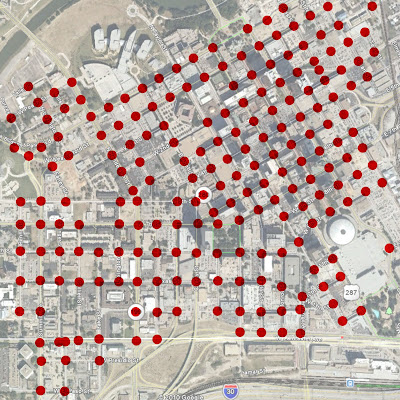
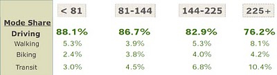
Downtown Fort Worth: 208 intersections per square mileThe result is actually barely above what Dallas achieved. Like Dallas, downtown Fort Worth exists on an island, surrounded on four sides by essentially man-made anti-urban devices fraying the urban grid as it departs the central core of downtown. For a comparison to how this relates to walkability and transportation modal share,
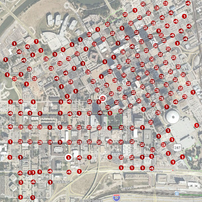
find this link or see the below graphic (numbers across the top represent intersections per square mile):
Fort Worth is very disconnected from its surrounding fabrics, often with a singular connection to the adjacent neighborhoods. This is revealed as the density of dots or intersections breaks down outside of the Main Street core.
Having personally walked the downtowns of all of the above towns, the rankings of the three downtowns in terms of walkability matches my own sense. Downtown Fort Worth is very walkable, but only in the core between the convention center and the Tarrant County Courthouse.
In relation, Portland also has a much bigger downtown area uninterrupted by disconnective agents. Portland also has done a better job dealing with freeways, which are sunken with the urban grid extending across, maintaining walkability for a more consistent and broader area.
Similar to Fort Worth, Portland also has a river and waterfront forming an edge, however Portland, having removed a freeway have done a better job of breaking down the edge by creating a more publicly accessible riverfront park.
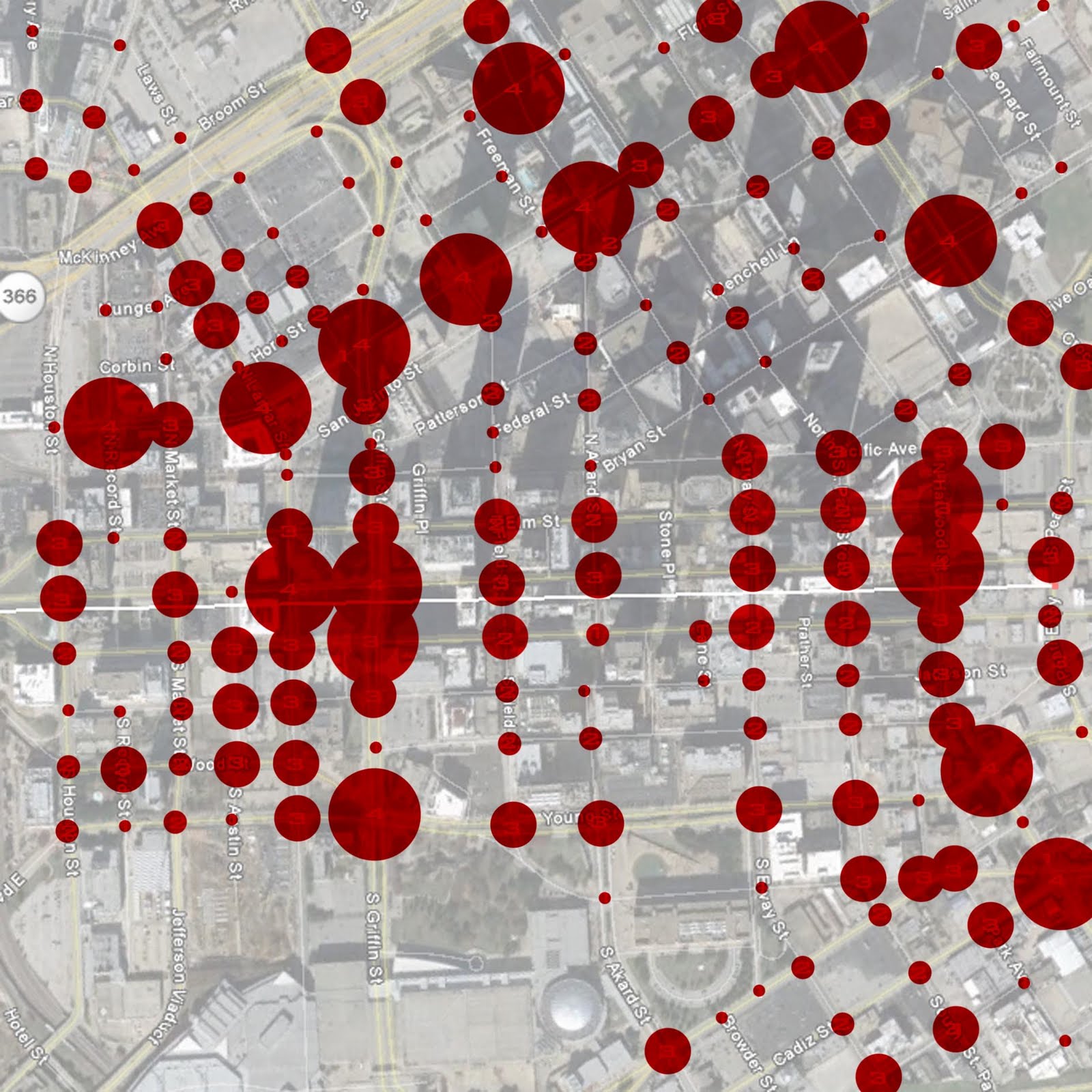
When applying the point system based on intersection convergence we get the following breakdown by intersection:
With a mile square aerial of downtown at 200 px, I applied a similar graphic scale by point system to each intersection as follows:
1 - 20 px
2 - 40 px
3 - 80 px
4 - 160 px
The resulting graphic:
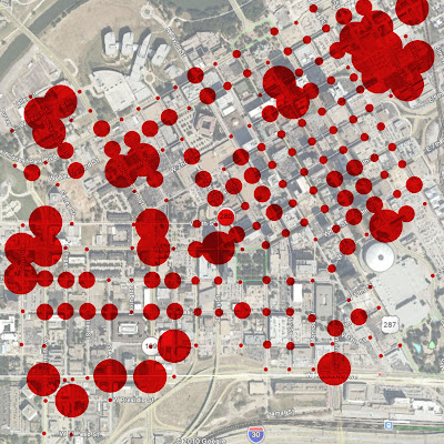
RESULTS:
Downtown Dallas: 391 intersection points per square mile
Downtown Portland: 746 intersection points per square mile
Downtown Fort Worth: 455 intersection points per square mile
The first thing that I wanted to examine was the ratio between intersections per mile and weighted intersections per mile. Dallas and Portland came out to .476 and .477 respectively, or remarkably similar. Fort Worth's ratio is .457, somewhat below, but still amazingly close. My guess is this slight reduction might be due to the high number of T-intersections in downtown Fort Worth (which I admittedly may underweight).
Conclusions:
The most obvious conclusion is that I'm overweighting four-way intersections. I pointed out this probability in the last study, but it had not yet been so dramatic. The biggest splotches of red in the above graphic represent four-way intersections with the intent that the most people are moving past these intersections. Except in Fort Worth these are almost without exception limited to the various peninsulas of development radiating from the downtown core, mostly the intersections of minor streets. It is obvious there needs to be some definition between types of streets forming those intersections.
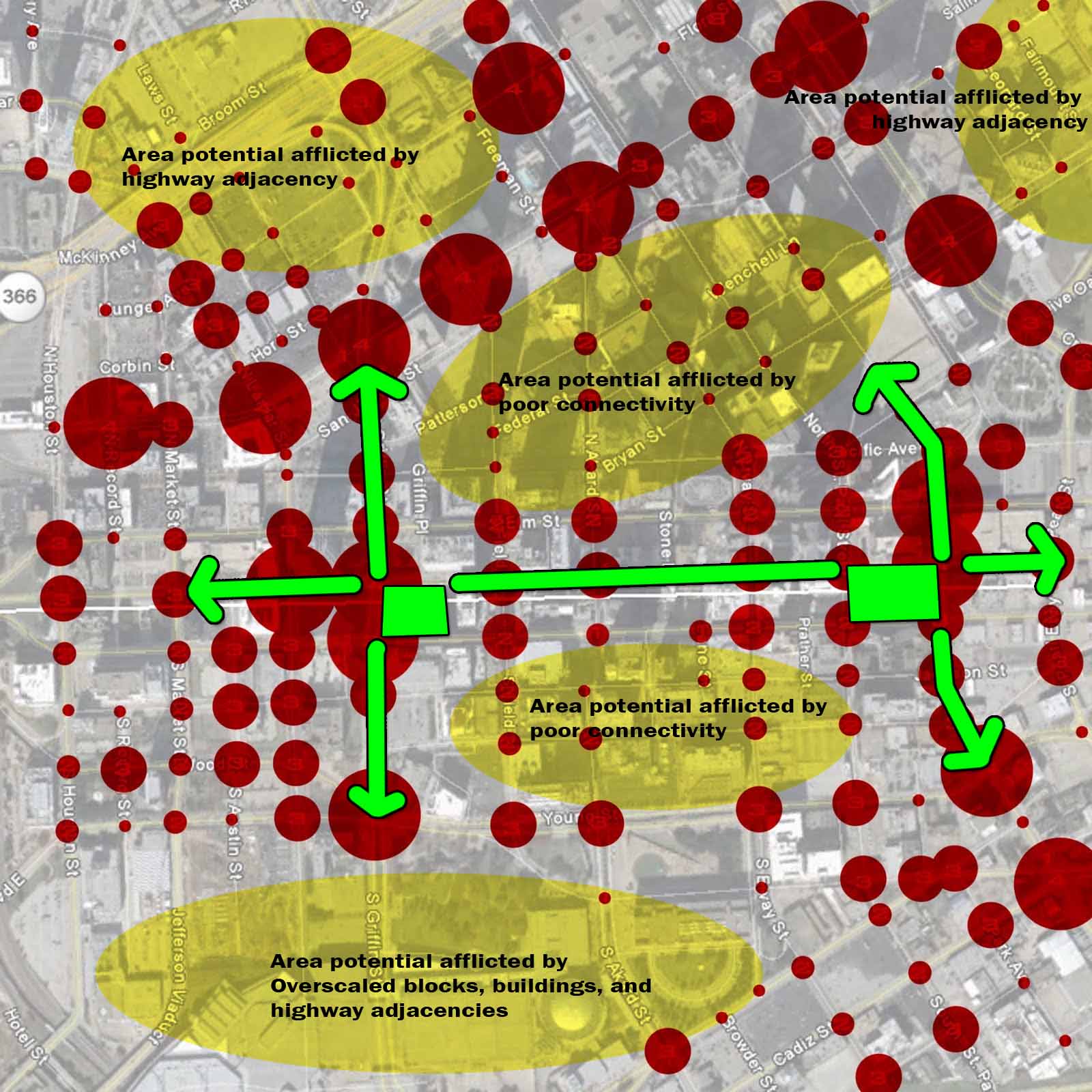
As I pointed was probably necessary, downtown Fort Worth gets the first Meta-Convergence analysis. To do so, I highlighted all of the roads that connect beyond the district, the primary linkages between the downtown area and the adjacent neighborhoods. Where a four-way intersection got four points for the four directions people approached the intersection in the basic convergence analysis, for the Meta-Convergence I give a bonus point for every direction that arrives on a primary "stem." So a four-way intersection between two primary links could achieve up to 8 points rather than the four as previous.
To maintain 160px as the maximum I rearranged the pixels per intersection so as to not overlap on nearby intersections by the following point system:
1 = 20 px
2 = 40 px
3 = 60 px
4 = 80 px
5 = 100 px
6 = 120 px
8 = 160 px
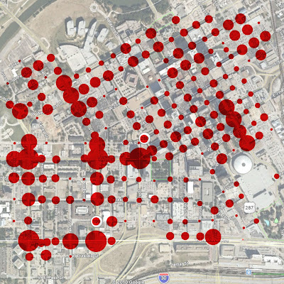
While there are still some outliers, this starts to make more sense. Since I reduced all of the dot sized by points, this graphic can not be directly compared to the above simple convergence graphics, but only to examine within its context, certain parts of the downtown or intersections to other intersections.
One thing this reveals, is the off-center nature of downtown Fort Worth on its "island" and the potential for downtown to expand to the West.
In general, the Meta-Convergence analysis is best at showing opportunity areas where the density and real estate values are underperforming. Most often this is due to the vary roads creating the traffic. The design of the roads are strictly for cars and the buildings and people then withdraw from that road. This is "inside-out" urbanism.
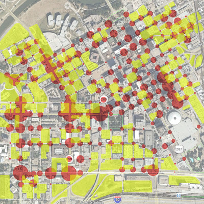
When we add in a graphic for "under-performing" or underdeveloped sites we predictably see that most of the underdeveloped sites have a direct relationship with the locations of the car-oriented street framework.
The question then becomes, are these properties really underperforming? In my opinion, the answer is that the surface parking (or parking garages) are a direct market response to a terrible, unsustainable transportation design and network. Parking is the highest and best use, but not a great (or walkable) downtown does it make.
So while there is great potential in where red and yellow overlap, the responsibility lies on the public-side to overhaul the primary roads to something that can move more traffic in a people- and place-friendly manner.
Complete streets are 1) centripetal, in that they draw people to them rather than centrifugal streets which are repellent, 2) can move more traffic by moving less cars (meaning increased modal share via more efficient transportation modes), and most importantly 3) link to the vastly underdeveloped areas immediately adjacent to downtown.
These are the neighborhoods within the 1 to 3 mile radius of downtown where bikes and streetcars make the most sense and will leverage increased development.
This study reveals that the most potential lies along Henderson and W. 7th for both downtown expansion and inner-ring (outside of downtown) development. But the primary barrier to this potential is the overly wide, pedestrian unfriendly design of the both streets.
A couple of questions remain:
Does the new Meta-Convergence properly weight intersections? My guess is no, leading to some outliers of four-way intersections on streets that may see less than 100 cars per day.
Have we factored in various other "magnetic" forces such as parks?Not yet. I also haven't begun applying subjective "punishment" of certain intersections or roads for being particularly egregious. There are also local factors such as Fort Worth's bizarre tendency to build parking garages or other buildings over streets. I'm sure this seemed like a good idea at the time, but I also haven't figured out how to properly demerit a street or intersection for this.
Other issues to expand on:There needs to be another level of analysis that where intersections of a certain density begin to multiply off each other, perhaps there are bonus points for uninterrupted grids. This is why the downtown core of Fort Worth is a bit undervalue here, in my opinion. But objectively, I still feel the base Meta-Convergence graphic can stand on its own, particularly in how it suggests the potential of downtown to expand Westward.
Next time, I also hope to apply the "bonded" study which examines the segments between intersections for how permissible crossing of the various streets are. There would have to be a healthy dose of subjective professional judgment applied to this in cities where I'm not terribly familiar with the specific dynamics of a street based on personal experience and examination.