


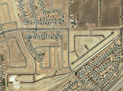
The diplomatic answer would be converting any street to a complete street is a step in the right direction.
The real answer is that Bishop is .75 miles from end to end. Who is going to ride on it? Cyclists need places to go and we need to have the courage to implement complete streets on real streets that matter.
Is a Bishop complete street going to help a commuter get to their job downtown? Or to the eventual improvements on the Trinity? It needs to happen on Davis. That is the spine of Oak Cliff.
Why not stick with Tyler and the Better Block?????
That made real, fundamental change to how the street behaved. If I can Jaywalk across Bishop or Main any time of day, those are streets that aren't in need of "diets" or urgent need for improvement.
To me this is kind of like trying to improve Main Street. A street that is already working, taking a +1 street to a +2 street isn't as impactful as taking a -1 street to a +1 street if you follow me. This is why downtown shouldn't put money into Main (the cherry on top) until it focuses on the problematic streets (Elm, Commerce, Griffin, etc.).
The idea of convergence is to not segregate modes of travel in order to establish hierarchy of places, spaces, streets, density, and use.
Our streets are public places. They have to be designed to attract people not repel them. We can't be afraid to "complete" our actual arterials so our city is no longer "inside out" where density and vitality is away from the actual movement of the city, the traffic (ped, bike, car, bus, etc).
I fear that implementation on Bishop might lead us down a path where bike lanes and complete streets only occur on minor streets. If that is the case then this is a waste of time and we won't impact the city's form, shape, and dynamics in any meaningful way and we're just playing in the sandbox.
Now, if the Bishop plan is considered the phase 1 for eventually expanding to Davis and Jefferson, then ok but I would rather see it on a street that goes somewhere and it can be phased to extend over time for a greater segment of the same street and draw from a larger area.
Showing posts with label Complete Streets. Show all posts
Showing posts with label Complete Streets. Show all posts
Thursday, June 10, 2010
Bishop Ave Complete Street Meeting
The City is unveiling a complete street design for Bishop Ave tonight. I was asked about it in the comments and decided it would be best to pull them out for a post of their own. Warning: Some may not like hearing the truth:
Wednesday, April 28, 2010
The Role Governments Play
So we have two recent reports out, one from the Harvard Business Journal showing just how timely they are in the article: Smart Money is Moving Back to the City. They seem so proud. So prescient.
In the second article, Kaid Benfield from NRDC writes in the Washingtonian that it is already happening.
Need a more striking graphic:
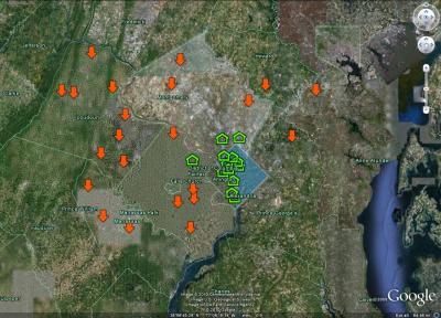
Orange arrows mean a local drop in housing prices of 25% or greater. Green monopoly house graphic means the opposite. Hmmmm, Harvard. I think the smart money was in long ago. Glad to have you at the table.
This however does raise a few issues. Obviously, in our country, in our time, the private market makes the cities. However, to ignore government agencies roles in doing so is to not understand our system in the first place. The invisible hand is attached the invisible arm. And if the invisible hand is wandering aimlessly around the countryside, it ends up leaving behind the wastes of its explorations.
Well, on the bright side, it tested the value of exurban land, and found that it is far less than the value of the similarly isolated single family house now sitting on it.
So what does that mean for us here in DFW, real estate, new urbanism, and just plain old urbanism. I often point out that probably the most serious of all issues creating sprawl and underperforming urban environments is the disconnection between transportation planning and design and its counterpart of placemaking or city building.
What I find most interesting about the "new urbanism" of the past two decades, is that even the best projects occurred in all the wrong places. At best they were road side attractions. At worst they were positioned at the end of a virtual cul-de-sac. Take Addison Circle for example. It was only built where it was because of the availability of land. Urban forces however, if they weren't at odds, would want that kind of development along Belt Line Road. Addison Circle is the center of community, but off-center.
Because of the failings of DOTs, City, and State policies, the real estate industry stomps around cluelessly hoping to squeeze value out of any and all piece of land that they can get their hands on cheaply. It is a process built on wish and prayer. "We're gonna develop this property and hope people come." It is supply side rather than demand driven. Creating well-designed points of convergence is city building, it is also economic development. It removes the barriers to delivering supply to a pent-up demand wanting to be near movement, near activity, at the heart of places. It makes the real estate industry smart and productive rather than the enemy of NIMBYism.
Commerce needs activity, it needs movement and predictability of location. Commerce is driven by emotional need. Here is where it is important to point out that consumerism by nature isn't bad. It is the material waste inherent in open-loop systems that is particularly insidious. Commerce is the exchange of goods, services, ideas, and genes. It has to happen. It is biologically wired into us.
However, our transportation planning and road design has undermined this. "High Streets," "Main Streets," and markets always occurred at crossroads, at intersection points, at points of convergence. Density wants to be at these convergence points, which is exactly what downtowns are/were until we gutted them with highways.
The real estate market needs predictability to infuse intelligence into the price and value of land. Otherwise, we end up with a supply of development in the middle of nowhere with no demand to match. Las Colinas once fit this bill and it has taken at least two generations to slowly ingratiate it with the rest of the City. Hence, it was a financial flop for the longest time until the introduction of DART to provide some level of convergence, of predictability, of movement.
Our highways and arterial system are repulsive forces. Nobody wants to be on them nor near them. But, we have no choice. They are unsafe and inhumane. The very nature of their planning and design violates the nature of convergence and how cities function (and their economies). Our points of convergence, the intersections of our busiest streets have to the be most pleasantly designed. The most enjoyable to be on or otherwise, our local economies will continue to leak oil, literally.
Complete Streets, Context-Sensitive Design, and incentive-laden TODs are all steps in the right direction. All of which would allow the private market (the hand) adapt the City to and work cohesively with the transportation network established by government agencies (the arm). So why do we keep widening roads when we have some of the worst traffic in the country:
Here is where it is important to remind of the corruption that once plagued streetcars, then railroads, and now highways. Too many are dependent upon that breast milk. We're like an 18-year old still living in the basement with an Oedipus Complex.
A monopoly is never good for markets, but particularly in transportation it becomes exceptional corrosive. If for no other reason, we need a range of transportation choices just to undermine the corruption that occurs within any one dominant form. History doesn't repeat but it rhymes.
In the second article, Kaid Benfield from NRDC writes in the Washingtonian that it is already happening.
Need a more striking graphic:
Orange arrows mean a local drop in housing prices of 25% or greater. Green monopoly house graphic means the opposite. Hmmmm, Harvard. I think the smart money was in long ago. Glad to have you at the table.
This however does raise a few issues. Obviously, in our country, in our time, the private market makes the cities. However, to ignore government agencies roles in doing so is to not understand our system in the first place. The invisible hand is attached the invisible arm. And if the invisible hand is wandering aimlessly around the countryside, it ends up leaving behind the wastes of its explorations.
Well, on the bright side, it tested the value of exurban land, and found that it is far less than the value of the similarly isolated single family house now sitting on it.
So what does that mean for us here in DFW, real estate, new urbanism, and just plain old urbanism. I often point out that probably the most serious of all issues creating sprawl and underperforming urban environments is the disconnection between transportation planning and design and its counterpart of placemaking or city building.
What I find most interesting about the "new urbanism" of the past two decades, is that even the best projects occurred in all the wrong places. At best they were road side attractions. At worst they were positioned at the end of a virtual cul-de-sac. Take Addison Circle for example. It was only built where it was because of the availability of land. Urban forces however, if they weren't at odds, would want that kind of development along Belt Line Road. Addison Circle is the center of community, but off-center.
Because of the failings of DOTs, City, and State policies, the real estate industry stomps around cluelessly hoping to squeeze value out of any and all piece of land that they can get their hands on cheaply. It is a process built on wish and prayer. "We're gonna develop this property and hope people come." It is supply side rather than demand driven. Creating well-designed points of convergence is city building, it is also economic development. It removes the barriers to delivering supply to a pent-up demand wanting to be near movement, near activity, at the heart of places. It makes the real estate industry smart and productive rather than the enemy of NIMBYism.
Commerce needs activity, it needs movement and predictability of location. Commerce is driven by emotional need. Here is where it is important to point out that consumerism by nature isn't bad. It is the material waste inherent in open-loop systems that is particularly insidious. Commerce is the exchange of goods, services, ideas, and genes. It has to happen. It is biologically wired into us.
However, our transportation planning and road design has undermined this. "High Streets," "Main Streets," and markets always occurred at crossroads, at intersection points, at points of convergence. Density wants to be at these convergence points, which is exactly what downtowns are/were until we gutted them with highways.
The real estate market needs predictability to infuse intelligence into the price and value of land. Otherwise, we end up with a supply of development in the middle of nowhere with no demand to match. Las Colinas once fit this bill and it has taken at least two generations to slowly ingratiate it with the rest of the City. Hence, it was a financial flop for the longest time until the introduction of DART to provide some level of convergence, of predictability, of movement.
Our highways and arterial system are repulsive forces. Nobody wants to be on them nor near them. But, we have no choice. They are unsafe and inhumane. The very nature of their planning and design violates the nature of convergence and how cities function (and their economies). Our points of convergence, the intersections of our busiest streets have to the be most pleasantly designed. The most enjoyable to be on or otherwise, our local economies will continue to leak oil, literally.
Complete Streets, Context-Sensitive Design, and incentive-laden TODs are all steps in the right direction. All of which would allow the private market (the hand) adapt the City to and work cohesively with the transportation network established by government agencies (the arm). So why do we keep widening roads when we have some of the worst traffic in the country:
Hey John. You know what costs Americans time and money. Your industry. IntraCity highways are a drain. The cause, not the solution. How many studies do we need to undermine this nonsensical thinking?John Horsley, Executive Director of the American Association of State Highway and Transportation Officials, relayed the information during a news conference Monday at the National Association of County Engineers' annual conference.
The AASHTO's report, Transportation Reboot: Unlocking Gridlock, is the first in a series aimed at boosting transportation capacity.
It identifies what the agency considered needed projects across the country, including in Texas.
The study says bottlenecks cause 40% of all congestion, and the gridlock costs Americans time and money.
The solutions presented Monday include using millions of dollars to build new highways.
Texas, however, does not have the funding.
Here is where it is important to remind of the corruption that once plagued streetcars, then railroads, and now highways. Too many are dependent upon that breast milk. We're like an 18-year old still living in the basement with an Oedipus Complex.
A monopoly is never good for markets, but particularly in transportation it becomes exceptional corrosive. If for no other reason, we need a range of transportation choices just to undermine the corruption that occurs within any one dominant form. History doesn't repeat but it rhymes.
Monday, April 19, 2010
Industrial Boulevard

Every invisible hand is attached to the invisible arm of government. ~paraphrased from a quote by Ted Goranson in an interview by Alex Marshall in the book How Cities Work.
Over the weekend, the Unfair Park blog by the Dallas Observer has a link to a City Council presentation updating plans to make Industrial Boulevard Complete, by apparently not "completing" it at all. Here is blog buddy Jason Roberts of Bike Friendly Oak Cliff's response:
It’s a 6 lanes + 2 turn lanes street with glorified sidewalks being developed as “cycle tracks” for shared bicycle and pedestrian use. In other words, its form is:The following is how I respond:Pedestrian/Bicycle, Car, Car, Car, Car, Car, Car, Car, Car, Bicycle/Pedestrian
There are multiple reasons to develop a complete street including lessening CO2 emissions, allowing for/enabling multiple transit options, enlivening an area with pedestrians, and greater economic development potential. Problems with our current streetscapes are that there is far too much weight given to one mode of transit which lessens the likelihood of use for any other. What are we trying to enable? Pedestrianization of an area, or automotive through-way? When it’s far easier to drive than it is to walk or bicycle, why attempt another mode? And who exactly would want to walk, or dine, or bicycle beside a 6 lane arterial?
I concur with Jason's assessment. Streets such as these are 1) sorry attempts at compromise to appease the rabble, and 2) barriers to local economic activity despite its purpose as "connector." They are centrifugal rather than centripetal, meaning the public realm has to be safe, attractive, and amenable to cross-shopping, pedestrians crossing streets, buildings "communicating" with the buildings across the street, etc. in order to draw people to focal points of activity.The area needs space. It is incredibly constrained. Why not make Industrial the attraction, by reducing traffic flow lanes, recapturing the Right-of-way and rolling that extra land into development sites. That way you incentivize development by improving the livability, safety, and possibility of Industrial rather than spending on pig lipstick and then doubling down on the subsidy that it would take to invite private developers to the area.
(ed: added for this posting) Commerce needs concentration and it always has. Road design like this prevents concentration and promotes dispersal which undermines social space, economic activity, and urban integration.
Given how fragmented the area is by the River swath, the highways, the rail lines, AND Industrial Blvd, maintaining a certain capacity of traffic ignores the relationship between transportation and development and the public right-of-way's dual role as link and place. It will hinder any and all attempts to "upgrade" the developments in and around this area.
If we want to qualitatively improve the development in this area, somebody has to have the gumption to say that vehicular capacity is one of the hindrances and it should be reduced in order to make private investment even viable.
If the street network isn't made more livable, then in order to attract any investment it has to be subsidized. Rather than subsidize development, subsidize livability and watch the private investment flock to it.
To paraphrase a quote that I once heard a friend use, "that kind of compromise is like a car-boat. It's not a good car and it's not a good boat."
And because I'm OCD about finishing thoughts, I add-on:
Reticence to the "complete street" movement is understandable. It comes from the conventional wisdom established over 80 to 90 years of urban and transportation planning. Unfortunately, that conventional wisdom AND the planning behind it were all incorrect and have been failures.
Economic activity requires concentration. This is why the most expensive time slots for advertising are when the most people are watching. The most expensive real estate is where the most people are. The shopping mall was a natural reaction to big roads undermining the convergence or concentration of people. But, the shopping mall is largely being undone by the same issue, its disconnection from the rest of the urban fabric.
Roads are important delivery systems for concentration. However, if the road isn't "tamed" to be more pedestrian friendly, then it undermines concentration. It becomes an agent of dispersal rather than concentration. Residential then disperses because the preponderance of unsafe, undesirable, inhumane roads. Then retail has no choice but to follow the pattern of dispersal, reducing cross-shopping, concentration, and vitality.
Also, if the road isn't "tamed" then any "urban" development nearby have to effectively turn their back on the road. The cutting edge in urban planning is showing that this too is not effectively allowing properties to reach their highest and best use or value. Studies reveal that for every deviation from a main stem or axis (the turning off of an arterial) shows a correlated reduction in real estate value.
(Some even suggest that every slight turn of a street may as well, but this can also be compensated by improved place and character of winding streets.)
This is why before assembly line, industrialization, and theoretical planning, et al began undermining thousands of years of adapted city evolution, that real estate value and density clustered along the "High" Street or "Main" Street.
On the other hand, the current design of our streets also reduces adjacent value. Developers, whether for residential, retail, or mixed-use want to be near the concentration that arterials provide, but also want to be nowhere near them.
20th century transportation policies have put the "economy of place" at odds with the "movement economy" undermining economic activity, efficiency, and value.
Monday, April 12, 2010
Emergent Urbanism in Oak Cliff


I've been planning a post on graffiti as a livability indicator for a long time, but haven't quite found the exact narrative for which to frame the argument. The general gist would be that like its urban sisters density and gentrification, it comes in various forms: good, bad, destructive, harmless, or helpful. Because their meanings are so broad and contextually driven, these words often end up being code words masking other intent.
As with the above, sometimes it can be art. Sometimes it can be crude but so illuminating when shown in contrast. The contrast highlighted here is one of mere local sentiment but deeper represents the disconnect between goals and the policies that are failing to see the vision realized, preventing real neighborhood vitality from taking place.
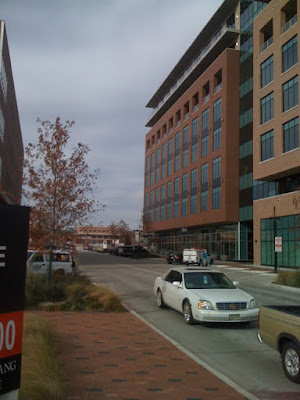
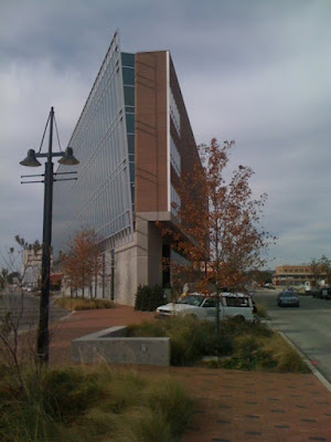
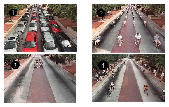
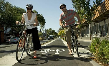
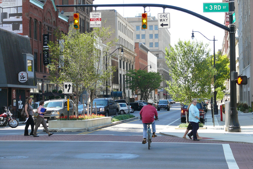
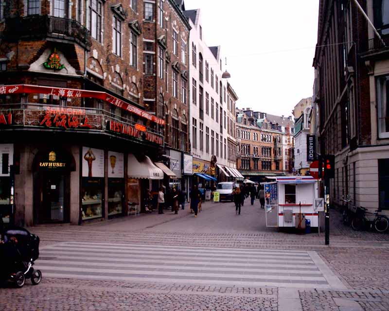
Yesterday, at the invite of Jason Roberts of multiple fames: Bike Friendly Oak Cliff, Build a Better Block Project, and band Happy Bullets, I was able to head down to X+ in Oak Cliff and check out their "citizen's arrest" of an untamed public street. In this case, it was the quasi-guerilla conversion of Tyler Street into a "complete street" that has been getting some publicity in local media circles.
What is a complete street you ask? It is a street that dedicates equal priority to various forms of transportation (or the opposite of) within the right-of-way (or building face to building face). This might include just vehicular travel, parking, sidewalk, and outdoor seating. In busier locations, it could also include various forms of transit such as dedicated bus or other mass transit lines. The purpose is to regain the necessary safety for pedestrian life to occur by limiting the domination of spaces by car travel and the infrastructural design supporting dangerous speeds through places.
In action, the conversion of just one block of Tyler Street had a profound effect on safety (at least perceived), enjoyment, livability, AND commerce for the local businesses. Jason relayed to me that the local bookstore, Cliff Notes, had their best sales day ever on Saturday, the first day of the staged "complete street."
In conceptual terms, what Roberts and others did was to apply greater differentiation to the street hierarchy. In the traffic planning world, hierarchy is fairly simple. Each street generally gets one classification (arterial, connector, local, etc.) and that is that. The street is generally designed to be the exact same no matter the location or context. What this has done is effectively flip the natural order of things: where the most traffic is, the most density wants to be, and the most activity happens. Our street design was so car-oriented that the streets cutting through neighborhood centers such as this one became repellents rather than attractors; barriers to activity and economic development.
What occurred over the weekend at Tyler Street was the intuitive application of a second (and necessary) metric to street design hierarchy, that of Place. Using a two-dimensional tool for street design is a growing concept in both Australia and in Great Britain, places similarly afflicted by poor street design and transportation planning, but not to the extend here.

(graphic pulled from this presentation by Prof. Peter Jones)
I find it far more effective in appropriating design based on the dual purpose of streets which is the backbone of the report by the same name: Link and Place which details that public rights-of-way can be one or the other, or even both. If both is the goal then certain design elements are critical to allowing link and place to occur simultaneously considering efforts at "saving time" can often be in conflict with the desire to "spend time."
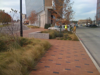
Because the transformation of Tyler Street occurred only on one block the contrast between street as Link and street as Place was striking. See for example this picture looking south along Tyler where the Street remained untouched:

Wide. Narrow, inconsistent sidewalks. No parking except off-street. It isn't a stretch of the imagination for you to take my word for it that these cars were driving in excess of 45 mph despite their static pose for this shot. We know that speed regulation and enforcement is an utter failure of policy and expenditure of resources. Cars and their operators will only drive as safe as the conditions and design of the street allow them to feel comfortable to do so.
So what happened when these cars hit something out of the ordinary?

Break lights.

Are those break lights? Sure look like it.

Let's look closer at the third car... yep, those are break lights. In fact, the cars would drive so slowly through the "Better Block" that people felt comfortable enough to "jaywalk" and even blindly cross the street without even looking for oncoming traffic. That's a safe street. The environment ensured it. This delay of possibly an extra 15 seconds of each driver's life was reacted to not with rage but more often of admiration and amazement. One overheard comment, "I wish my street was like this."


People of all ages showed up to socialize, people watch, and "spend time," representative of "slow" living that allows us to take time and enjoy life and the company of others, differentiating us as humans from the assembly line logic of traffic planning.


Above: yes, that is a set of turntables on a mounted rig on a bike. Below, adding to the ambience of urbanism, the sensory experience whether it was tastes from the Brownies in a Jar from around the corner, or the sounds of bongos played on the sidewalk, or the smells emanating from the coffee shop, the complete street fostered a participatory environment where businesses, residents, and visitors all took part, whether as performer or passive observer. All enjoyed experiencing the life so missing from so many parts of the City. All prevented by written policy. This was Jason Roberts' point.


Above: the painted bike lane with on-street parking at such a distance to avoid conflict between door openings and bike traffic.

One interesting lesson was that the street had been so effectively narrowed that the bike lane in effect was merely a rhetorical prop, much like the traffic lights. The kid in the above photo felt fully comfortable riding in circles on the street, as did his parents nearby. However, it should be pointed out that the bike lane would increase in efficacy as it lengthens and extends further along the street defining the place for bike traffic as a street morphs in various forms or design sections based on its place within the Link/Place matrix.


It has yet to be listed or defined as a livability indicator, but the presence of bicycles clearly is one that relates to Babies! or AYFs. It is one that is predicated upon safety. At Tyler Street yesterday (and presumably the day before) there were strollers and bicycles a plenty.
Once safety, lowest on the Maslow Hierarchy of Needs, is achieved (when cars, the most deadly of transportation modes, no longer have priority of space) only then can culture be meaningfully introduced. With the right urbanity, the right platform, it occurs naturally through citizen created vitality. Art and Music were both present in a place we could call a real arts district, where more people (and culture) were on each day of the weekend than the named Arts District (which illuminates the challenge of the Dallas Arts District).
This can't just happen anywhere however. As I pointed out to Jason yesterday, these will be most successful in the areas where it is most inconvenient, areas with the most convergence, which naturally form the centers of neighborhoods.
[The sound you just heard was not another stadium implosion, but the brains of ten traffic engineers exploding as their world, their belief system is no longer valid. Their bibles for how to move cars are instantly irrelevant.]
Neighborhoods throughout the city deserve similar experiences, places to go that are within walking distance and spend an afternoon cheap on the wallet but valuable to the soul, with family and old friends, or new ones (hopefully just friends, but for the single folk, perhaps make new families too. Walkable DFW does not sanction polygamy.). However, the transportation system deters this from happening. In our attempt to allow for the most amount of traffic through our neighborhood centers, we eliminated the ability to have the most amount of traffic (foot traffic), and in turn, do the most business.
Will these compete with malls or power centers in terms of sales receipts? No, but neighborhood scaled activity hubs are central to our every day lives. This is real economic development that doesn't take the nonsensical public spending on highways, but rather by eliminating the barriers to real urbanism is what economic development should be all about. As I have said before, intra-city commerce can occur in any form, it is up to us to determine the right transportation network to build and foster the formats which we would prefer.
What the Tyler Complete Street represents:
The last part is the scariest. It gives the most credence to the growing notion that centralized planning is defunct. In some ways it is, but only in the way Frank Gehry and others understand the 20th century version of planning. To say all public/government led planning is failed and that this version is the only ideal version is also false. As I've said before, it is about eliminating the barriers to both economic and community development. In most cases, this means undoing the "planning" of the 20th century: the highway and arterial system.
- Citizens taking their streets back. They've paid for them, and are unhappy with the way their streets have been mismanaged and designed in a way that hinders quality of life.
- Street behavioralism at work - and its interrelated connection with "place" creation.
- And relatedly, the utter failure of traffic and transportation policies and how they relate with city form and urban design.
See New York City where Transportation Commissioner Janette Sadik-Khan is transforming that City with some paint and jersey barriers, redefining the public realm to prioritize pedestrian activity rather than vehicular movement. It is the difference between buying a potted plant and actual gardening. It is about creating the platform, fostering and tending to places to encourage vibrancy rather than attempting to bestow it. And the public sector has the onus on removing the barriers by correcting its mistakes. It will be paid off in spades with a real "World Class City" rather than one that we so often incorrectly label as one.
In many ways, fostering urbanism is about letting go of control. Gardens and ecosystems don't grow optimally with over pruning. A world class city is one that people love. People loved what was happening at X+ yesterday and in Bishop Arts with the Arts Crawl. I know I loved it.
Monday, January 25, 2010
W. 7th in Fort Worth and Retail as Place Driver
I have talked about what the future of retail will look like several times before (here and here) and I'll be hitting on the same issues discussed in those, within this post which is directed at a real place, still in its hatchling stages of development.
In particular in one of the previous posts, I discussed where retail in dallas will re-congregate, with particular emphasis on the CityPlace/West Village area. Not because of anything particular that has yet been designed there, but rather the convergence that is established by infrastructure and coding (it's urban genotype) will ensure its success.
The fundamental point is something that I've been evolving and packaging for consumption since then: 21st century retail's need for 3 kinds of convergence:
Eventually as cities re-adapt to an organization less dependent solely on the auto, various retail "centers" will emerge into a hierarchy based on the quality of and quantity of types of convergence, ie to simplify necessarily, having 1 form would be a neighborhood center, 2 forms of convergence a town center, and 3-forms a regional center.
This is why, in Dallas, I know West Village/CityPlace will be successful as it continues to develop; I believe downtown will emerge from its slumber once again as it has these advantages built into its "Urban DNA", and traditional shopping malls like NorthPark can continue their success ONLY if they maximize all three forms of convergence. For NorthPark specifically despite its ongoing success in comparison with most malls, this means improving and simplifying connectiong to DART, as well as infilling its surface parking lots with residential density, pedestrian-friendly street grid, quality public spaces.
------------------------
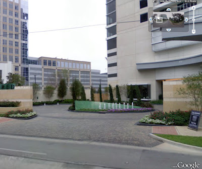
Meanwhile, as we live our own Dallas-centric exploration into the 21st century city, our neighbor to the West is working on a project that has similar level assets, if not more than any particular neighborhood in or near Dallas. This would be the new development at West 7th.
It has the cultural district within eyesight, is close to a Trinity River that is currently an amenity, closer to its downtown, is directly on the main link between downtown and the cultural district, whereas McKinney, the uptown main street is a right turn out of downtown. Using Hillier's axial studies, suggest each such redirections can have a profound affect on urban success or lack thereof, per axial shift.
West 7th the street is exactly the kind of overly wide arterial that materializes when design criteria is limited solely to traffic flow. Still speaking generally about arterial design, any aesthetic concerns for the pedestrian are an afterthought and appear exactly as such, and thus are not effective.
This kind of design typically leads to the type of decay and disinvestment of the immediate area, that ironically drives land value low enough that it can then be redeveloped into something better when efforts coalesce and a developer is confident that his surroundings will improve as well, protecting his/her investment...which is exactly what has happened here. In some ways, it just reinforces the idea that places often have to bottom out before they get better (see: the amount of attention and intelligence directed at Detroit currently.)
The plan at the W. 7th project creates its primary "place," one street parallel to 7th. You could say that this is a mistake from a theoretical standpoint, but as I stated in another recent post, it is a necessary compromise. The primary concern must be to build enough critical mass to create a "place" from Day 1, something that holds together. This, to date, has been the inherent flaw in the neighboring project Museum Place, which one might argue has the superior architecture.
The plan and design at W. 7th understood all of these issues. The potential of the future, but the necessity to hedge bets if 7th was never fully to become a street designed as both link and place.
Seeing that 7th currently is not a street designed for people (who would live on it right now?), they've done exactly what they should have done, not completely turn its back on 7th, but ingratiate itself with the grid as well as to design flexibility and adaptability of the building to interact w/ 7th in a way that can change hand-in-hand as 7th evolves. Success now. And predictably moreso in the future.
Once 7th is redesigned as a more pedestrian-friendly, complete street, it has the opportunity to be a "place" itself - as streets can be either links or places themselves. Currently, as with most streets it was designed specifically for moving traffic, meaning it is a link - but to maximize value and well-being of the local citizenry.
Why is it important to flip the modernist inside-out street design back to rightside-out? Because there is the most energy there - if and when an arterial can be designed to be amenable to humans - then the most valuable uses will clamor to occupy space on that street to minimize the distance or disconnect from energy of people movement and their direct access...facilitating commerce. That distance is a cost increment extracted from the local economy: a fraction of a cent, multiplied over however many millions of transactions, like in Superman 3.
Imagery taken in December:
---------------------------
My last point is about the nearby Museum Place. As I stated, in my opinion it has excellent detailed architectural design and landscape architecture, but it doesn't yet feel like a place. With the efforts at the Cultural District, W. 7th, and Fort Worth's streetcar efforts, eventually it will. Like all cities throughout history that grew together, morphed, and coalesced, eventually it will all feel like one coherent place; a center close enough to downtown that provides a positive feedback loop with downtown Fort Worth, utilizing 7th street as the chains of the bicycle between pedals and spokes.
As of now however, the real story of all of this is that with its excellent detailed architecture and landscape design, Museum Place is held back by the street design around it.
Imagery:

In particular in one of the previous posts, I discussed where retail in dallas will re-congregate, with particular emphasis on the CityPlace/West Village area. Not because of anything particular that has yet been designed there, but rather the convergence that is established by infrastructure and coding (it's urban genotype) will ensure its success.
The fundamental point is something that I've been evolving and packaging for consumption since then: 21st century retail's need for 3 kinds of convergence:
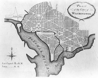
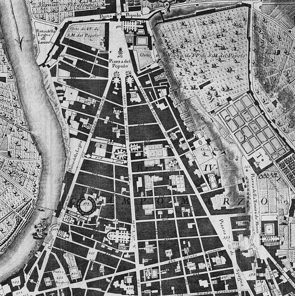
2-Dimensional convergence is what you see in a planometric drawing of a city, perfected during the Baroque and used effectively since. I often use the L'Enfant DC plan, Broadway's axial cut applying a hierarchy through New York's regular grid and Rome's various papal axes, in this case the trivium arriving at Piazza del Popolo (work of Ed Bacon also is very effective at teaching this) to illustrate this point:
What often happens however, is that these inherently create people spaces (moreso than retail spaces) as the convergence of multiple conduits requires an outlet, more space for the arriving people from various directions. For example, if you were to pour two or more full glasses of water into another vessel, you would need a larger container. Retail requires proximity of other stores meaning narrower distances for cross shopping, so the retail spills down Via Del Corso from Popolo, or Connecticut from DuPont Circle, or down any of the streets off Times Square.
3-Dimensional Convergence refers essentially to mixed-use buildings. If there are residents above and adjacent to the retail, there is a consistent base to support an amount adjusted exactly to the quantity of residents within walking (or elevator/stairs) distance. Quality of place then creates a larger draw which means more demand and a larger center.
4-Dimensional Convergence can refer to time of day, but more precisely I'll use it to suggest a multitude of useful forms of transit converging in one place, within certain time periods of each other, which requires some degree of regularity of arrivals. For mass transit, this means dependable and preferrably frequent stops nearby, with little to no changes in form of transit. Also, quality of place matters, creating a perception of safety for drivers, bikers, and walkers to feel comfortable arriving at any time of day.
Eventually as cities re-adapt to an organization less dependent solely on the auto, various retail "centers" will emerge into a hierarchy based on the quality of and quantity of types of convergence, ie to simplify necessarily, having 1 form would be a neighborhood center, 2 forms of convergence a town center, and 3-forms a regional center.
This is why, in Dallas, I know West Village/CityPlace will be successful as it continues to develop; I believe downtown will emerge from its slumber once again as it has these advantages built into its "Urban DNA", and traditional shopping malls like NorthPark can continue their success ONLY if they maximize all three forms of convergence. For NorthPark specifically despite its ongoing success in comparison with most malls, this means improving and simplifying connectiong to DART, as well as infilling its surface parking lots with residential density, pedestrian-friendly street grid, quality public spaces.
------------------------
Meanwhile, as we live our own Dallas-centric exploration into the 21st century city, our neighbor to the West is working on a project that has similar level assets, if not more than any particular neighborhood in or near Dallas. This would be the new development at West 7th.
It has the cultural district within eyesight, is close to a Trinity River that is currently an amenity, closer to its downtown, is directly on the main link between downtown and the cultural district, whereas McKinney, the uptown main street is a right turn out of downtown. Using Hillier's axial studies, suggest each such redirections can have a profound affect on urban success or lack thereof, per axial shift.
West 7th the street is exactly the kind of overly wide arterial that materializes when design criteria is limited solely to traffic flow. Still speaking generally about arterial design, any aesthetic concerns for the pedestrian are an afterthought and appear exactly as such, and thus are not effective.
This kind of design typically leads to the type of decay and disinvestment of the immediate area, that ironically drives land value low enough that it can then be redeveloped into something better when efforts coalesce and a developer is confident that his surroundings will improve as well, protecting his/her investment...which is exactly what has happened here. In some ways, it just reinforces the idea that places often have to bottom out before they get better (see: the amount of attention and intelligence directed at Detroit currently.)
The plan at the W. 7th project creates its primary "place," one street parallel to 7th. You could say that this is a mistake from a theoretical standpoint, but as I stated in another recent post, it is a necessary compromise. The primary concern must be to build enough critical mass to create a "place" from Day 1, something that holds together. This, to date, has been the inherent flaw in the neighboring project Museum Place, which one might argue has the superior architecture.
The plan and design at W. 7th understood all of these issues. The potential of the future, but the necessity to hedge bets if 7th was never fully to become a street designed as both link and place.
Seeing that 7th currently is not a street designed for people (who would live on it right now?), they've done exactly what they should have done, not completely turn its back on 7th, but ingratiate itself with the grid as well as to design flexibility and adaptability of the building to interact w/ 7th in a way that can change hand-in-hand as 7th evolves. Success now. And predictably moreso in the future.
Once 7th is redesigned as a more pedestrian-friendly, complete street, it has the opportunity to be a "place" itself - as streets can be either links or places themselves. Currently, as with most streets it was designed specifically for moving traffic, meaning it is a link - but to maximize value and well-being of the local citizenry.
Why is it important to flip the modernist inside-out street design back to rightside-out? Because there is the most energy there - if and when an arterial can be designed to be amenable to humans - then the most valuable uses will clamor to occupy space on that street to minimize the distance or disconnect from energy of people movement and their direct access...facilitating commerce. That distance is a cost increment extracted from the local economy: a fraction of a cent, multiplied over however many millions of transactions, like in Superman 3.
Imagery taken in December:
---------------------------
My last point is about the nearby Museum Place. As I stated, in my opinion it has excellent detailed architectural design and landscape architecture, but it doesn't yet feel like a place. With the efforts at the Cultural District, W. 7th, and Fort Worth's streetcar efforts, eventually it will. Like all cities throughout history that grew together, morphed, and coalesced, eventually it will all feel like one coherent place; a center close enough to downtown that provides a positive feedback loop with downtown Fort Worth, utilizing 7th street as the chains of the bicycle between pedals and spokes.
As of now however, the real story of all of this is that with its excellent detailed architecture and landscape design, Museum Place is held back by the street design around it.
Imagery:
Thursday, November 5, 2009
Ratcheting Down Roads to Crank Up Density
This post begins with the assumption, which I would call observed fact, that all development is a direct response to the primary mode of transportation serving the site (primary mode can also include multi-modal). When specifically applying a mode of transportation and accommodating it on a site, this assumption makes logical sense. It is the single most important determinant
For example, if everybody is travelling by car, the parking necessary takes up valuable FAR. Similarly, ports/docks are low density b/c everybody is on a boat b!tch. People arriving via transit are all on foot, pedestrians are on foot, and don't exactly need a place to put their shoes. And if they did, the foot lockers wouldn't exactly take up much space. That extra room for parking is either immediate for access (ie in front) or hidden to ameliorate the effect parking has on a building's ability to engage the public realm and participate in the multiplier effect of the "urban buzz."
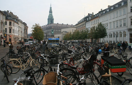
Copenhagen bike parking, compact and not sociofugal like a car park.
The two solutions are various shades of bad: very bad and less bad, because as I said it takes up valuable building/leasable space and it disconnects a building from its context thereby turning the building into a "non-sequitur" building, meaning it does not participate in the synergies that create a whole that is greater than the sum of the parts. Furthermore, the parking provision (and in cities where land and development is more expensive) has become a barrier to development, often accounting for upwards of 20% of a project cost.
To further the linguistic metaphor, in syntax, there are certain rules for things to come together to make sense (in cities these would be livable places). Once the rules are satisfied art can be applied to create poetry or prose and invoke even greater meaning. In cities, these become lovable places.
We obviously can't just start building without parking, as everybody (but me) is still stuck in a car on the road. But, we can alter the transportation network that informs the development density (and quality). I don't mean removing roads altogether, but slowly and incrementally ratcheting down the scale of many of the roads in the city and pinpointing any road designs that negatively affect urban tissue, creating places less than the sum of the parts.
Dallas is in the top five in the country in constructed freeway miles per capita. Extrapolated, it is probably pretty safe to assume that American cities dominate in the world list for this statistic as well, meaning that D/FW has nearly as many freeway miles per capita as any city in the world. Top Five WooHoo! Time to celebrate? No sir. And we're gonna drive from Dallas to Darmstadt, Germany to see how much money we're wasting.
---------------------------
As I posted the other day, Prof. Bill Hillier discussed development density, how it is created and defined by the density of the local grid network. The combination of the two components combine to create "urban buzz," or as I would describe as the facilitation of synergistic economic activity.
Obviously, economic factors have to exist to have demand for population to be there in the first place, the grid is then the application of a platform for increasing economic activity. The economic purpose makes for a VIABLE city. The grid allows for a LIVABLE CITY. And, as I said earlier, applying CIVIC ART then creates for MEMORABLE or LOVABLE cities.
You can't just start laying out a grid in the middle of nowhere and expect "urban buzz," but that won't stop people from trying apparently:
The visual mind virus of Bizarro Keynesian Meme. Build roads, expect development = stupid supply side urban development, rather than incrementally allowing demand for new development and expansion of the grid to accommodate it. This is what we mean by not overextending yourself financially by way of infrastructure.
Looking further into why Cities have roads and what purpose they serve, Hillier also talks of the necessity of local and global connections. Let me refine this dichotomy to include a greater range of: local, city, metropolitan, regional, global. Extracting Jane Jacobs, highways are essentially global connections b/c they link global hubs ie airports to cities (as macro destination), as well as cities to cities - for example Houston area to Dallas area. The grid then allows the connections from microdestination to microdestination, or intermideate destination (such as a transpo hub) to microdestination (your house, your job, third places, etc.). As Hillier suggests, the local grid connects everywhere to everywhere and allows the necessary flexibility of choice to get there without all traffic funneled to overly hierarchical dendritic arterial systems.
So we have our five road "connections, which I'll number by intensity or volume:
1. Local
2. City
3. Metropolitan
4. Regional
5. Global
Each of these connective "purposes" has an appropriate design solution that either can engender high quality, dense urban development or do just the opposite. This post will show examples of both.
Oft repeated schematic illustrating spatial relationship and densities of people by mode of transpo. As you can see accommodating modes other than cars allows for greater capacity. Moving greater capacity is supposed to be any transpo engineers job. Greater capacity moving by a site, equates to a higher "highest and best use," meaning more predictably successful commercial enterprises, more "urban buzz." Oh, and as we'll see, it just looks nicer, feels nicer.
Looking specifically at Dallas, anyone that approaches downtown from the North via the Dallas Tollway arrives into the City experiencing a descension of hierarchy from road type 5 all the way down to 1. This is what we mean when we say context sensitive design. The street capacity is reduced as the road descends further into the City. However, as we'll see, Context Sensitive Design can be poorly sensitive or misinterpreted as the roads are all poorly designed, strictly for the maximum amount of cars and little else (like a DART bus or two) meaning not operating to full capacity as the picture above shows.
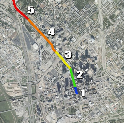
This entry experience will follow a 2-mile stretch of roadway as the Tollway as it merges with and becomes Harry Hines, until it turns into Akard St. until it terminates at AT&T and Golden Boy!
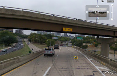
Category 5 (failed autocentric version): Characterized by flyovers, overpasses, cloverleafs, and related over-engineering. Notice that no development wants to engage with roads like this in any way and some futile attempts to "green" it up is made to make it barely palatable, ie more sunk costs.
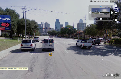
Category 4 (failed autocentric version): I believe we are near Harry Hines and Wolf here. The street now has traffic lights, six! lanes (all each too wide as well), and a pointless sidewalk right up to the curb. Often has surface parking in front to provide "access" and the only thing noticeable is a KERA billboard for drivers b/c nobody is expected to be on this road on foot. You'll also note that this is one-way here, meaning it has a mirrored overly wide, poorly design street running parallel one block to the East.
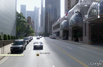
Category 3 (failed autocentric version): It's actually two-way with some on-street parking here, yet it isn't exactly helping business, except that we're greeted by a porte cochere and two curb cuts. Prime example of a building relating to the form of transportation. You're obviously arriving by car, we'll design our entry to greet cars. Oh, and a blank wall.
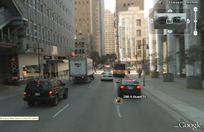
Category 2 (failed autocentric version): Back to one-way. Apparently, we have yet to learn that businesses need two-way streets to maximize predictable visibility and locational choices. As we said earlier, commercial success (and urban buzz) requires as many people moving by as possible (a focusing of the energy of human movement). Two-ways is better than one. Also, on-street parking is available at points along this street but it is spotty. We see another covered porte cochere and a sidewalk with no buffer from moving vehicles.
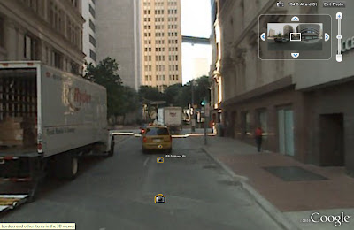
Category 1 (failed autocentric version): Given that this is at the intersection of Main Street (the one area of successful urbanism in downtown) and the Harry Hines/Tollway funnel, this should one of the most important and successful streets in Dallas. Main Street works, but as of yet, the "buzz" hasn't spilled southward toward the poor, imprisoned Golden Boy. This is partially due to the design of the street which doesn't convey its importance (and I don't mean widening). It feels like a back alley.
So what have these roads bought us? Well, because they are design to be sociofugal (and repel people), they become escape routes. As I suggested earlier this week, countering the argument that big roads deliver people to a city, it's a zero-sum game in terms of people coming and going on those roads, but when you factor in what they have done to the real estate, the extra cost of widened (virtually) car-only roads has decimated real estate development and urban density.
The density WE DO have is designed to be entirely auto-centric as well, with large parking garages as well as front doors that are little more than car drop-offs/porte cocheres.
The street edge is even defined by walls.agggh, more tree lawns!!! kill me!!!!
Furthermore, all of this high-rise residential/condominium development dotting lower McKinney is entirely a by-product of the falsely created, irrational housing exuberance of the past ten years. If it had to do with actual demand (one, it would be filled), it wouldn't be so poorly designed in how it engages the public realm.
So what are examples of roads that these should look like? Well, I'm glad you asked.
A better #5 - limited to the outskirts of the city. Very few$750 Million overpasses/interchanges, because highway to highway interaction is rarely four-way and they don't intersect every two miles. Lined mostly by natural buffers, development is rare except at the highway to boulevard hubs. There are no frontage roads, which bleed the "movement economy" energy from the lower level streets, which can better accommodate development.
A better #4 - ignore that this is the Champs Elysees which acts as a "main street" of Paris. 4's should be the primary vehicle traffic movers of any metropolitan region and can accommodate development directly interfacing with and benefitting from the energy moving by on the street because of the buffers created by the allees of trees, a browsing/parking parallel "slip" lane, and ample sidewalks. These streets still require a development coding maintaining a linear street wall to maximize use to use adjacency/synergy.
A better #3 - a lesser version, or lower scaled "complete street" from #4.
A better #2 - Main Street in downtown Dallas would be a good number 2. However, I would categorize it in the Dallas hierarchy as a 1, the lowest capacity because the road hierarchy is on steroids. The theme of this post is that in Dallas, all of the roads, need to go on "road diets" and scale from bad 2's to good 1's. Bad 4's to good 3's.
A better #1 - Rather than alleys, we start using terms like woonerf or mews. Examples include Stroget (the carfree area in Copenhagen) or even the small side streets with cars near Stroget that will probably go carfree soon anyway. Point being, cars can still get through as you see above, but it's primarily only delivery vehicles. Who else would want to try to drive through there? Curbs aren't necessary b/c bikes, pedestrians, strollers, pedicabs, you name it all have equal right-of-way to the space. This is the epitome of street as space.
So what does all of this mean for Dallas? Dude, you're full of something, not sure if it's questions.
I thought we were driving to Darmstadt. Are we there yet?
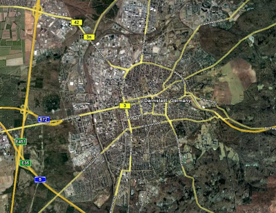
Yes. This is Darmstadt, Germany. When placed over Dallas at a similar scale, we get this:
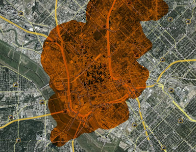
Darmstadt is a city of 142,000 people. The orange shows all of Darmstadt minus the "boroughs" of Eberstadt, Arheilgen, and Wixhausen (all compact suburban satellites off the map, but still within city proper) taking the total population of the orange area down to approximately 100,000.
It should be noted that Darmstadt also barely has any buildings over ten stories, other than the middle finger building (shown below), of course. Most of which are steeples or various other associated vertical elements with civic/cultural edifices.
I wonder where or towards whom it is facing? Probably Munchen.
While not entirely accurate, the orange area covers the equivalent of Dallas zip codes 75201, 75202 (downtown) and 75204 (uptown), meaning we're probably looking at a max residential population of about 25,000, or one-fourth of Darmstadt's density.
As you can see from the aerial, its compact nature allows for preservation of nearby agricultural land for food production as well as natural forests/habitat. The freeways are all exterior to the actual city preventing them from having the corrosive, deleterious effect upon the urban fabric which we know all too well. The city is then accessed by roads lower on the hierarchy.
If as the saying goes, "density buys amenity," apparently in Dallas we just buy entirely too much car infrastructure which means that much less in the way of amenity and livability.
P.S. I have a much more in depth post looking at Darmstadt that has been about half-way done for about a year. I'll try to get that finished within the next week.
For example, if everybody is travelling by car, the parking necessary takes up valuable FAR. Similarly, ports/docks are low density b/c everybody is on a boat b!tch. People arriving via transit are all on foot, pedestrians are on foot, and don't exactly need a place to put their shoes. And if they did, the foot lockers wouldn't exactly take up much space. That extra room for parking is either immediate for access (ie in front) or hidden to ameliorate the effect parking has on a building's ability to engage the public realm and participate in the multiplier effect of the "urban buzz."
Copenhagen bike parking, compact and not sociofugal like a car park.
The two solutions are various shades of bad: very bad and less bad, because as I said it takes up valuable building/leasable space and it disconnects a building from its context thereby turning the building into a "non-sequitur" building, meaning it does not participate in the synergies that create a whole that is greater than the sum of the parts. Furthermore, the parking provision (and in cities where land and development is more expensive) has become a barrier to development, often accounting for upwards of 20% of a project cost.
To further the linguistic metaphor, in syntax, there are certain rules for things to come together to make sense (in cities these would be livable places). Once the rules are satisfied art can be applied to create poetry or prose and invoke even greater meaning. In cities, these become lovable places.
We obviously can't just start building without parking, as everybody (but me) is still stuck in a car on the road. But, we can alter the transportation network that informs the development density (and quality). I don't mean removing roads altogether, but slowly and incrementally ratcheting down the scale of many of the roads in the city and pinpointing any road designs that negatively affect urban tissue, creating places less than the sum of the parts.
Dallas is in the top five in the country in constructed freeway miles per capita. Extrapolated, it is probably pretty safe to assume that American cities dominate in the world list for this statistic as well, meaning that D/FW has nearly as many freeway miles per capita as any city in the world. Top Five WooHoo! Time to celebrate? No sir. And we're gonna drive from Dallas to Darmstadt, Germany to see how much money we're wasting.
---------------------------
As I posted the other day, Prof. Bill Hillier discussed development density, how it is created and defined by the density of the local grid network. The combination of the two components combine to create "urban buzz," or as I would describe as the facilitation of synergistic economic activity.
Obviously, economic factors have to exist to have demand for population to be there in the first place, the grid is then the application of a platform for increasing economic activity. The economic purpose makes for a VIABLE city. The grid allows for a LIVABLE CITY. And, as I said earlier, applying CIVIC ART then creates for MEMORABLE or LOVABLE cities.
You can't just start laying out a grid in the middle of nowhere and expect "urban buzz," but that won't stop people from trying apparently:
The visual mind virus of Bizarro Keynesian Meme. Build roads, expect development = stupid supply side urban development, rather than incrementally allowing demand for new development and expansion of the grid to accommodate it. This is what we mean by not overextending yourself financially by way of infrastructure.
Looking further into why Cities have roads and what purpose they serve, Hillier also talks of the necessity of local and global connections. Let me refine this dichotomy to include a greater range of: local, city, metropolitan, regional, global. Extracting Jane Jacobs, highways are essentially global connections b/c they link global hubs ie airports to cities (as macro destination), as well as cities to cities - for example Houston area to Dallas area. The grid then allows the connections from microdestination to microdestination, or intermideate destination (such as a transpo hub) to microdestination (your house, your job, third places, etc.). As Hillier suggests, the local grid connects everywhere to everywhere and allows the necessary flexibility of choice to get there without all traffic funneled to overly hierarchical dendritic arterial systems.
So we have our five road "connections, which I'll number by intensity or volume:
1. Local
2. City
3. Metropolitan
4. Regional
5. Global
Each of these connective "purposes" has an appropriate design solution that either can engender high quality, dense urban development or do just the opposite. This post will show examples of both.
Oft repeated schematic illustrating spatial relationship and densities of people by mode of transpo. As you can see accommodating modes other than cars allows for greater capacity. Moving greater capacity is supposed to be any transpo engineers job. Greater capacity moving by a site, equates to a higher "highest and best use," meaning more predictably successful commercial enterprises, more "urban buzz." Oh, and as we'll see, it just looks nicer, feels nicer.
Looking specifically at Dallas, anyone that approaches downtown from the North via the Dallas Tollway arrives into the City experiencing a descension of hierarchy from road type 5 all the way down to 1. This is what we mean when we say context sensitive design. The street capacity is reduced as the road descends further into the City. However, as we'll see, Context Sensitive Design can be poorly sensitive or misinterpreted as the roads are all poorly designed, strictly for the maximum amount of cars and little else (like a DART bus or two) meaning not operating to full capacity as the picture above shows.
This entry experience will follow a 2-mile stretch of roadway as the Tollway as it merges with and becomes Harry Hines, until it turns into Akard St. until it terminates at AT&T and Golden Boy!
Category 5 (failed autocentric version): Characterized by flyovers, overpasses, cloverleafs, and related over-engineering. Notice that no development wants to engage with roads like this in any way and some futile attempts to "green" it up is made to make it barely palatable, ie more sunk costs.
Category 4 (failed autocentric version): I believe we are near Harry Hines and Wolf here. The street now has traffic lights, six! lanes (all each too wide as well), and a pointless sidewalk right up to the curb. Often has surface parking in front to provide "access" and the only thing noticeable is a KERA billboard for drivers b/c nobody is expected to be on this road on foot. You'll also note that this is one-way here, meaning it has a mirrored overly wide, poorly design street running parallel one block to the East.
Category 3 (failed autocentric version): It's actually two-way with some on-street parking here, yet it isn't exactly helping business, except that we're greeted by a porte cochere and two curb cuts. Prime example of a building relating to the form of transportation. You're obviously arriving by car, we'll design our entry to greet cars. Oh, and a blank wall.
Category 2 (failed autocentric version): Back to one-way. Apparently, we have yet to learn that businesses need two-way streets to maximize predictable visibility and locational choices. As we said earlier, commercial success (and urban buzz) requires as many people moving by as possible (a focusing of the energy of human movement). Two-ways is better than one. Also, on-street parking is available at points along this street but it is spotty. We see another covered porte cochere and a sidewalk with no buffer from moving vehicles.
Category 1 (failed autocentric version): Given that this is at the intersection of Main Street (the one area of successful urbanism in downtown) and the Harry Hines/Tollway funnel, this should one of the most important and successful streets in Dallas. Main Street works, but as of yet, the "buzz" hasn't spilled southward toward the poor, imprisoned Golden Boy. This is partially due to the design of the street which doesn't convey its importance (and I don't mean widening). It feels like a back alley.
So what have these roads bought us? Well, because they are design to be sociofugal (and repel people), they become escape routes. As I suggested earlier this week, countering the argument that big roads deliver people to a city, it's a zero-sum game in terms of people coming and going on those roads, but when you factor in what they have done to the real estate, the extra cost of widened (virtually) car-only roads has decimated real estate development and urban density.
The density WE DO have is designed to be entirely auto-centric as well, with large parking garages as well as front doors that are little more than car drop-offs/porte cocheres.
The street edge is even defined by walls.
Furthermore, all of this high-rise residential/condominium development dotting lower McKinney is entirely a by-product of the falsely created, irrational housing exuberance of the past ten years. If it had to do with actual demand (one, it would be filled), it wouldn't be so poorly designed in how it engages the public realm.
So what are examples of roads that these should look like? Well, I'm glad you asked.
A better #5 - limited to the outskirts of the city. Very few
A better #4 - ignore that this is the Champs Elysees which acts as a "main street" of Paris. 4's should be the primary vehicle traffic movers of any metropolitan region and can accommodate development directly interfacing with and benefitting from the energy moving by on the street because of the buffers created by the allees of trees, a browsing/parking parallel "slip" lane, and ample sidewalks. These streets still require a development coding maintaining a linear street wall to maximize use to use adjacency/synergy.
A better #3 - a lesser version, or lower scaled "complete street" from #4.
A better #2 - Main Street in downtown Dallas would be a good number 2. However, I would categorize it in the Dallas hierarchy as a 1, the lowest capacity because the road hierarchy is on steroids. The theme of this post is that in Dallas, all of the roads, need to go on "road diets" and scale from bad 2's to good 1's. Bad 4's to good 3's.
A better #1 - Rather than alleys, we start using terms like woonerf or mews. Examples include Stroget (the carfree area in Copenhagen) or even the small side streets with cars near Stroget that will probably go carfree soon anyway. Point being, cars can still get through as you see above, but it's primarily only delivery vehicles. Who else would want to try to drive through there? Curbs aren't necessary b/c bikes, pedestrians, strollers, pedicabs, you name it all have equal right-of-way to the space. This is the epitome of street as space.
So what does all of this mean for Dallas? Dude, you're full of something, not sure if it's questions.
I thought we were driving to Darmstadt. Are we there yet?
Yes. This is Darmstadt, Germany. When placed over Dallas at a similar scale, we get this:
Darmstadt is a city of 142,000 people. The orange shows all of Darmstadt minus the "boroughs" of Eberstadt, Arheilgen, and Wixhausen (all compact suburban satellites off the map, but still within city proper) taking the total population of the orange area down to approximately 100,000.
It should be noted that Darmstadt also barely has any buildings over ten stories, other than the middle finger building (shown below), of course. Most of which are steeples or various other associated vertical elements with civic/cultural edifices.
I wonder where or towards whom it is facing? Probably Munchen.
While not entirely accurate, the orange area covers the equivalent of Dallas zip codes 75201, 75202 (downtown) and 75204 (uptown), meaning we're probably looking at a max residential population of about 25,000, or one-fourth of Darmstadt's density.
As you can see from the aerial, its compact nature allows for preservation of nearby agricultural land for food production as well as natural forests/habitat. The freeways are all exterior to the actual city preventing them from having the corrosive, deleterious effect upon the urban fabric which we know all too well. The city is then accessed by roads lower on the hierarchy.
If as the saying goes, "density buys amenity," apparently in Dallas we just buy entirely too much car infrastructure which means that much less in the way of amenity and livability.
P.S. I have a much more in depth post looking at Darmstadt that has been about half-way done for about a year. I'll try to get that finished within the next week.
Subscribe to:
Posts (Atom)


