Empiricism suggests otherwise once all of the auxiliary, correlated, and causal effects are effectively weighed which are either too inconvenient or too complicated for the anti-streetcar crowd. Fortunately, if this is what their final stand has come down to, streetcar vs. buses, then we (and our cities/economies) are in good shape for the future.
First, streetcars being on fixed alignments provide greater predictability for the real estate development market to properly associate price/value potential of a site given its proximity to the line. It instills a hierarchy, an awareness for what works rather than trial and error urbanism. While real estate development is guided by an “invisible hand,” that hand is always tied to an invisible arm, that being government and public investment. Do we want a smart, efficient, guided real estate delivery system or a dumb one that stumbles around the edges trying to either create real estate value from scratch or hoodwink people? See the housing bubble.
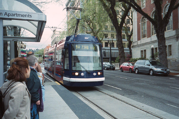
History has proven streetcars to be a far more effective tool in catalyzing development (particularly the high quality urban development the Mayor has stressed) whereas buses and their “greater mobility” aka greater inefficiency effectively doom themselves by their own inefficiency and sparse building patterns.
Second, modern streetcars are more accessible for the disabled, handicapped, elderly with the flat loading and along with their increased predictability for real estate the public awareness of the line is greater. The simplicity of alignments allows the linkage of important place to important place not only physically but in the collective consciousness of the community. They know where to catch it and where it will take them. So if people can’t get on a bus or don’t know where to catch it or how many transfers they have to take, all deter from the mobility you are claiming that comes from some antiquated or outright false theology.
Third, buses must be replaced every 3 to 5 years and are a maintenance nightmare due to their construction and internal combustion engines whereas Dallas and other cities have streetcars running that are a century old.
Lastly, and perhaps most importantly, the modern streetcars are slick, sleek, and represent progress. Much of the engine of the private market place is psychological and often irrational, driven by consumer/investor confidence. Initiating that confidence in the 21st century sustainable city, with positive symbols of which all cities who have them are inherently proud, is one of those steps to pulling a recessionary economy out of the doldrums.
Lastly, buses will still be part of the equation, but as circulators for the less dense areas of cities at the edges linking with other rungs of the hierarchy such as DART, TRE, AND streetcar. There has to be a multiplicity of solutions, an ecology of sustainable modes of transportation including more walkable/bikable development with associated improved public infrastructure. The effective load of buses will be lessened. Streetcars will serve and drive the physical form of areas 1 to 3 miles from the primary hub or job center being downtowns.
The empirical history of city evolution is the best lesson and will provide a far better guidebook than the misguided theology of the 20th century that so misguided us such as the theory of mobility (much of which was driven by the car/oil/gas industries successfully seeking monopolies) but rather real mobility through actual and differentiated choice, fundamental to any real marketplace of which the City is the ultimate one.
Wednesday, December 8, 2010
Blast from the Past, On Streetcars
Monday, October 4, 2010
Guerilla Urbanism Spreads to Fort Worth
The effects of the project were immediate and dramatic. People gathered on South Main in unheard of numbers. There were no traffic congestion problems or disasters - cars could still travel nicely, but they did so at a much, much slower rate. This relaxed the street, giving people on the sides a comfortable feel that made them want to hang out and browse the art, food, and shops. Bicycles rolled freely and safely along the nice wide bike lanes. Kids played where once nothing but pavement existed.
Wednesday, September 29, 2010
Fort Worth's Diet Plan
Since they’re re-topping the pavement anyway, the city is going to re-stripe to narrow 7th Street from six lanes + turn to four lanes + turn, and add on-street parking and bike lanes. The intent is to slow down traffic on the over-engineered high-speed street and make it more hospitable to pedestrians and cyclists, as well as safer for all users by slowing traffic. In essence, trying to turn the street from being a “link” to being a “place,” to go hand-in-hand with the new walkable/bikeable mixed-use development that’s occurring along it.Vindication! Two things: You may recall me writing about W. 7th and the potential in the area that was held back by the current street function and design. Find that piece here. I have it on good authority that that piece was sent all the way up to State Senator Wendy Davis by local property owners. Furthermore, around that same time, I gave a presentation in Fort Worth that used those exact words, "link" and "place," so I'm glad those seeds have sprouted out west. Here are the slides for you to see and understand the concept as well:
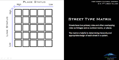
Here is the matrix, borrowed from British traffic engineer Peter Jones.
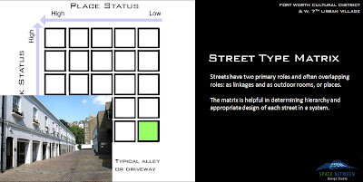
Link/Place: Low/Low - alley
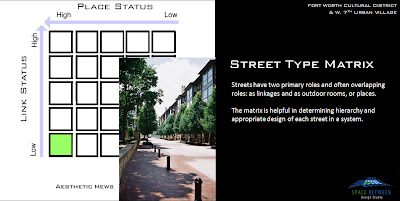
Link/Place: Low/High - Designed Mews
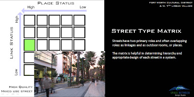
Link/Place: Med/High - Predominantly Pedestrianized Mixed-Use Street
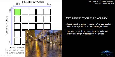
Link/Place: High/High - Preeminent, Champs Elysees. High design, moves all forms of transportation. Still amenable to street life and pedestrians with adequate +/- 50% of spatial envelope.
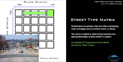
Link/Place: High/Low. West 7th currently, and nearly all other arterials in the Metroplex. With public coffers crippled by low sales tax receipts, the city is unable to transition directly from Low to High "place" value, it can incrementally do so by first transitioning the function of the street.
In many ways, this is better as it becomes in essence a pilot project for the city since people tend to reject change until they see it can work. Once it works functionally, and becomes more amenable to street life as pedestrians and bicycles, investment will surely follow. With a little bit of paint they are able to change the psychology of the area. This is strategically no different than what the Better Block is doing in Oak Cliff, what Janette Sadik-Khan is doing in NYC, or what the City of Plano did fifteen years ago narrowing K Ave through downtown Plano.
The key to this, is that the new, eventual investment will then leverage the upgrading of the aesthetics of the street to then match the quality of the development that happens. Baby steps people, baby steps, but we're at least stepping the right direction for once.
Peter Jones, your legacy will be felt in probably the last place you would ever expect it.
Thursday, July 29, 2010
Bring on the Streetcar
Via FortWorthology, there is a great OpEd at the Star-Telegram in favor of, well accepting the Federal money for a streetcar. Duh.
Let's recap. In both Dallas and Fort Worth, we have several "neighborhoods" ripe for reinvestment. They were originally created by streetcar as outward pressure and a new technology "unlocked" the value of the land a mile or a few outside of the City Center. For a variety of reasons, the lines failed, mostly through a lack of density.To many, before this discussion started, a return of the streetcar sounded more like a tourism gimmick than a game-changing modern transit system. Two years into the discussion, however, most of us actively working to revitalize our central city would never call the proposed modern streetcar a gimmick. We have seen how the competitive advantages of walkable, transit-oriented urbanism have returned and how modern streetcar systems are transforming central cities into sustainable economic engines.
Companies are locating along modern streetcar lines, and developers are building thousands of housing units along existing city streets instead of along new and expensive roads at the edge of town. Highly skilled workers with choices are shopping for cities that offer a full range of transportation options.
Fort Worth needs to enhance its appeal to new businesses and residents. We can't ignore the negative effects of sprawl-related problems -- congestion, unhealthy air and far too many generic developments that aren't sustaining their value. Those issues have deep roots and won't go away soon, making it clear that we must promote a vibrant, distinctive and prosperous central city to stay competitive with our peers and that we must act quickly.
Skeptics of streetcars generally fall into two-camps: those that have their interests against such things as freedom of mobility, ie controlling interests in a monopoly of transportation and those that hide behind some religion of "free market" willfully ignoring that no transportation in this country is designed or created by the "free market." This represents a letting go of the reigns of inertia that will ultimately grind our cities into some failed state while praying to that same religion to guide us into a happy afterlife of rainbows and unicorns. Fortunately, we have the power to steer that inertia towards a positive outcome, albeit not easily.
Cities need residential density. Streetcar needs density. These downtown-adjacent neighborhoods are the perfect spot, less burdened by the more intense activity of downtown business districts, while being close enough to those centers of gravity to walk, bike, or say streetcar to the amenities therein,
In order to deliver supply to match the demand for urban housing, these areas need transportation alternatives. Otherwise, the development will be engineered by and respond to car-oriented design. Meaning roads will be too overscaled and unwalkable. Parking facilities will be too big and therefore too expensive. And it all becomes a barrier to investment and you end up with a drive-thru McDonald's, which might generate 1/20th of the tax base. More potential residents move to a mind-numbing garden apartment in [insert suburb here so as to not offend one] built of sticks and paper and will last about twenty years before it becomes a slum and is then razed. Thumbs up.
Somewhat changing subjects...
There is a medium-sized town somewhere in this country I once suggested should look into unearthing their buried streetcar tracks as one component of a downtown revitalization plan. Shot down, too expensive. Of course it was. But, we're also talking about 30- or 50-year visions and available federal match. Another key strategy I proposed was to recapture excessive right-of-way in overly-scaled one-way streets through downtown.
The idea was two-fold. First, to calm traffic and "road diet" (verb) the streets so that they were more context-sensitive to a downtown location, and second, to roll that land into private development projects as an incentive to (re)develop into more intense, walkable and mixed uses and get some much needed residential back downtown. I've been seeing that idea pop up more and more across the country these days now that more budgets have burst.
Now? Streetcar porn:
Tuesday, June 15, 2010
Fort Worth Intersection Density Analysis
With the understanding that the grid (of whatever form) provides the neural network of urban economies, the end result, I believe, is one that merges walkability and hierarchy of urban spaces in order to identify problem areas of the City. It is also fun to play with, tweaking various streets and blocks, two-way conversions from one-ways, and seeing the potential transformative effects those changes can have on real estate potential.
The following is downtown Fort Worth run through the same analysis as Dallas and Portland (and I will be doing more downtowns and like this one, hopefully tweaking and advancing the metrics and capabilities of the analysis).
For the understanding and assumptions, please see this link. Where I amend some for the purposes of this study, I will detail those in this post.
------------------------------------
As you see below, in relation to downtown Dallas and many other similar cities, Fort Worth has very small blocks. The Fort Worth blocks at approximately 225' x 225' actually are more reminiscent of Portland, which would lead one to expect that Fort Worth would approach the Portland result for intersection density per square mile.

RESULTS:
Downtown Dallas: 186 intersections per square mile
Downtown Portland: 356 intersections per square mile
Downtown Fort Worth: 208 intersections per square mile
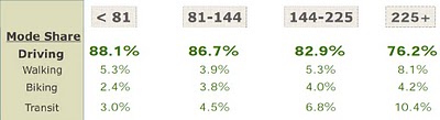
The result is actually barely above what Dallas achieved. Like Dallas, downtown Fort Worth exists on an island, surrounded on four sides by essentially man-made anti-urban devices fraying the urban grid as it departs the central core of downtown. For a comparison to how this relates to walkability and transportation modal share, find this link or see the below graphic (numbers across the top represent intersections per square mile):
Fort Worth is very disconnected from its surrounding fabrics, often with a singular connection to the adjacent neighborhoods. This is revealed as the density of dots or intersections breaks down outside of the Main Street core.
Having personally walked the downtowns of all of the above towns, the rankings of the three downtowns in terms of walkability matches my own sense. Downtown Fort Worth is very walkable, but only in the core between the convention center and the Tarrant County Courthouse.
In relation, Portland also has a much bigger downtown area uninterrupted by disconnective agents. Portland also has done a better job dealing with freeways, which are sunken with the urban grid extending across, maintaining walkability for a more consistent and broader area.
Similar to Fort Worth, Portland also has a river and waterfront forming an edge, however Portland, having removed a freeway have done a better job of breaking down the edge by creating a more publicly accessible riverfront park.
When applying the point system based on intersection convergence we get the following breakdown by intersection:

With a mile square aerial of downtown at 200 px, I applied a similar graphic scale by point system to each intersection as follows:
1 - 20 px
2 - 40 px
3 - 80 px
4 - 160 px
The resulting graphic:

RESULTS:
Downtown Dallas: 391 intersection points per square mile
Downtown Portland: 746 intersection points per square mile
Downtown Fort Worth: 455 intersection points per square mile
The first thing that I wanted to examine was the ratio between intersections per mile and weighted intersections per mile. Dallas and Portland came out to .476 and .477 respectively, or remarkably similar. Fort Worth's ratio is .457, somewhat below, but still amazingly close. My guess is this slight reduction might be due to the high number of T-intersections in downtown Fort Worth (which I admittedly may underweight).
Conclusions:
The most obvious conclusion is that I'm overweighting four-way intersections. I pointed out this probability in the last study, but it had not yet been so dramatic. The biggest splotches of red in the above graphic represent four-way intersections with the intent that the most people are moving past these intersections. Except in Fort Worth these are almost without exception limited to the various peninsulas of development radiating from the downtown core, mostly the intersections of minor streets. It is obvious there needs to be some definition between types of streets forming those intersections.
As I pointed was probably necessary, downtown Fort Worth gets the first Meta-Convergence analysis. To do so, I highlighted all of the roads that connect beyond the district, the primary linkages between the downtown area and the adjacent neighborhoods. Where a four-way intersection got four points for the four directions people approached the intersection in the basic convergence analysis, for the Meta-Convergence I give a bonus point for every direction that arrives on a primary "stem." So a four-way intersection between two primary links could achieve up to 8 points rather than the four as previous.
To maintain 160px as the maximum I rearranged the pixels per intersection so as to not overlap on nearby intersections by the following point system:
1 = 20 px
2 = 40 px
3 = 60 px
4 = 80 px
5 = 100 px
6 = 120 px
8 = 160 px

While there are still some outliers, this starts to make more sense. Since I reduced all of the dot sized by points, this graphic can not be directly compared to the above simple convergence graphics, but only to examine within its context, certain parts of the downtown or intersections to other intersections.
One thing this reveals, is the off-center nature of downtown Fort Worth on its "island" and the potential for downtown to expand to the West.
In general, the Meta-Convergence analysis is best at showing opportunity areas where the density and real estate values are underperforming. Most often this is due to the vary roads creating the traffic. The design of the roads are strictly for cars and the buildings and people then withdraw from that road. This is "inside-out" urbanism.

When we add in a graphic for "under-performing" or underdeveloped sites we predictably see that most of the underdeveloped sites have a direct relationship with the locations of the car-oriented street framework.
The question then becomes, are these properties really underperforming? In my opinion, the answer is that the surface parking (or parking garages) are a direct market response to a terrible, unsustainable transportation design and network. Parking is the highest and best use, but not a great (or walkable) downtown does it make.
So while there is great potential in where red and yellow overlap, the responsibility lies on the public-side to overhaul the primary roads to something that can move more traffic in a people- and place-friendly manner.
Complete streets are 1) centripetal, in that they draw people to them rather than centrifugal streets which are repellent, 2) can move more traffic by moving less cars (meaning increased modal share via more efficient transportation modes), and most importantly 3) link to the vastly underdeveloped areas immediately adjacent to downtown.
These are the neighborhoods within the 1 to 3 mile radius of downtown where bikes and streetcars make the most sense and will leverage increased development.
This study reveals that the most potential lies along Henderson and W. 7th for both downtown expansion and inner-ring (outside of downtown) development. But the primary barrier to this potential is the overly wide, pedestrian unfriendly design of the both streets.
A couple of questions remain:
Does the new Meta-Convergence properly weight intersections?
My guess is no, leading to some outliers of four-way intersections on streets that may see less than 100 cars per day.
Have we factored in various other "magnetic" forces such as parks?
Not yet. I also haven't begun applying subjective "punishment" of certain intersections or roads for being particularly egregious. There are also local factors such as Fort Worth's bizarre tendency to build parking garages or other buildings over streets. I'm sure this seemed like a good idea at the time, but I also haven't figured out how to properly demerit a street or intersection for this.
Other issues to expand on:
There needs to be another level of analysis that where intersections of a certain density begin to multiply off each other, perhaps there are bonus points for uninterrupted grids. This is why the downtown core of Fort Worth is a bit undervalue here, in my opinion. But objectively, I still feel the base Meta-Convergence graphic can stand on its own, particularly in how it suggests the potential of downtown to expand Westward.
Next time, I also hope to apply the "bonded" study which examines the segments between intersections for how permissible crossing of the various streets are. There would have to be a healthy dose of subjective professional judgment applied to this in cities where I'm not terribly familiar with the specific dynamics of a street based on personal experience and examination.
Monday, January 25, 2010
W. 7th in Fort Worth and Retail as Place Driver
In particular in one of the previous posts, I discussed where retail in dallas will re-congregate, with particular emphasis on the CityPlace/West Village area. Not because of anything particular that has yet been designed there, but rather the convergence that is established by infrastructure and coding (it's urban genotype) will ensure its success.
The fundamental point is something that I've been evolving and packaging for consumption since then: 21st century retail's need for 3 kinds of convergence:
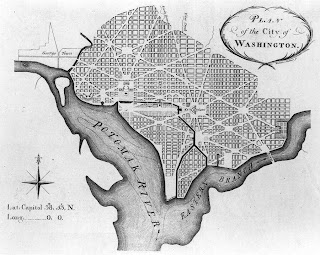
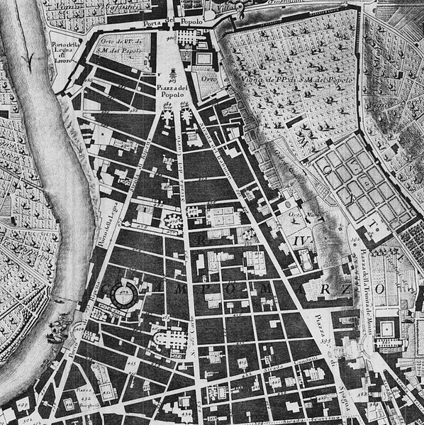
2-Dimensional convergence is what you see in a planometric drawing of a city, perfected during the Baroque and used effectively since. I often use the L'Enfant DC plan, Broadway's axial cut applying a hierarchy through New York's regular grid and Rome's various papal axes, in this case the trivium arriving at Piazza del Popolo (work of Ed Bacon also is very effective at teaching this) to illustrate this point:
What often happens however, is that these inherently create people spaces (moreso than retail spaces) as the convergence of multiple conduits requires an outlet, more space for the arriving people from various directions. For example, if you were to pour two or more full glasses of water into another vessel, you would need a larger container. Retail requires proximity of other stores meaning narrower distances for cross shopping, so the retail spills down Via Del Corso from Popolo, or Connecticut from DuPont Circle, or down any of the streets off Times Square.
3-Dimensional Convergence refers essentially to mixed-use buildings. If there are residents above and adjacent to the retail, there is a consistent base to support an amount adjusted exactly to the quantity of residents within walking (or elevator/stairs) distance. Quality of place then creates a larger draw which means more demand and a larger center.
4-Dimensional Convergence can refer to time of day, but more precisely I'll use it to suggest a multitude of useful forms of transit converging in one place, within certain time periods of each other, which requires some degree of regularity of arrivals. For mass transit, this means dependable and preferrably frequent stops nearby, with little to no changes in form of transit. Also, quality of place matters, creating a perception of safety for drivers, bikers, and walkers to feel comfortable arriving at any time of day.
Eventually as cities re-adapt to an organization less dependent solely on the auto, various retail "centers" will emerge into a hierarchy based on the quality of and quantity of types of convergence, ie to simplify necessarily, having 1 form would be a neighborhood center, 2 forms of convergence a town center, and 3-forms a regional center.
This is why, in Dallas, I know West Village/CityPlace will be successful as it continues to develop; I believe downtown will emerge from its slumber once again as it has these advantages built into its "Urban DNA", and traditional shopping malls like NorthPark can continue their success ONLY if they maximize all three forms of convergence. For NorthPark specifically despite its ongoing success in comparison with most malls, this means improving and simplifying connectiong to DART, as well as infilling its surface parking lots with residential density, pedestrian-friendly street grid, quality public spaces.
------------------------
Meanwhile, as we live our own Dallas-centric exploration into the 21st century city, our neighbor to the West is working on a project that has similar level assets, if not more than any particular neighborhood in or near Dallas. This would be the new development at West 7th.
It has the cultural district within eyesight, is close to a Trinity River that is currently an amenity, closer to its downtown, is directly on the main link between downtown and the cultural district, whereas McKinney, the uptown main street is a right turn out of downtown. Using Hillier's axial studies, suggest each such redirections can have a profound affect on urban success or lack thereof, per axial shift.
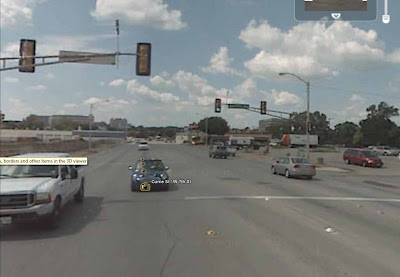
West 7th the street is exactly the kind of overly wide arterial that materializes when design criteria is limited solely to traffic flow. Still speaking generally about arterial design, any aesthetic concerns for the pedestrian are an afterthought and appear exactly as such, and thus are not effective.
This kind of design typically leads to the type of decay and disinvestment of the immediate area, that ironically drives land value low enough that it can then be redeveloped into something better when efforts coalesce and a developer is confident that his surroundings will improve as well, protecting his/her investment...which is exactly what has happened here. In some ways, it just reinforces the idea that places often have to bottom out before they get better (see: the amount of attention and intelligence directed at Detroit currently.)
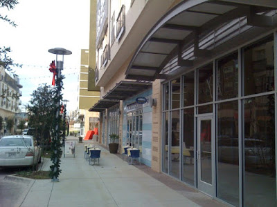
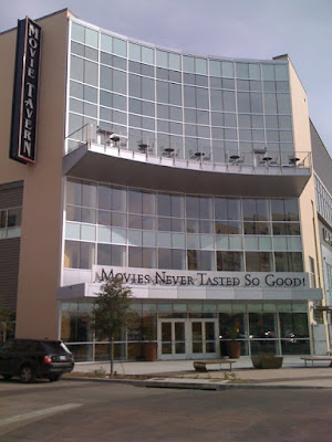
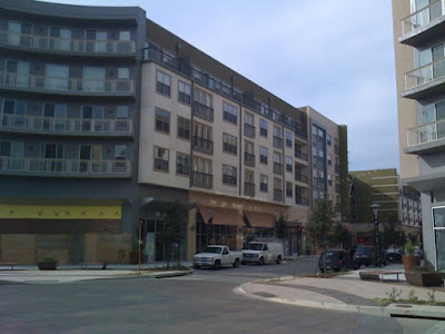
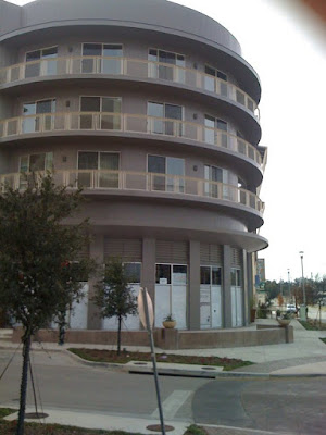
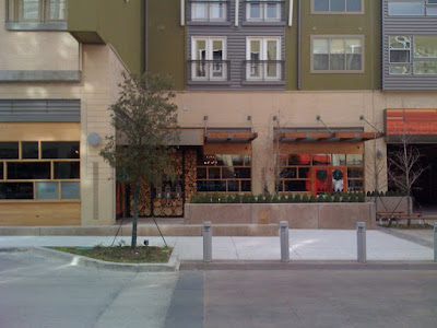
The plan at the W. 7th project creates its primary "place," one street parallel to 7th. You could say that this is a mistake from a theoretical standpoint, but as I stated in another recent post, it is a necessary compromise. The primary concern must be to build enough critical mass to create a "place" from Day 1, something that holds together. This, to date, has been the inherent flaw in the neighboring project Museum Place, which one might argue has the superior architecture.
The plan and design at W. 7th understood all of these issues. The potential of the future, but the necessity to hedge bets if 7th was never fully to become a street designed as both link and place.
Seeing that 7th currently is not a street designed for people (who would live on it right now?), they've done exactly what they should have done, not completely turn its back on 7th, but ingratiate itself with the grid as well as to design flexibility and adaptability of the building to interact w/ 7th in a way that can change hand-in-hand as 7th evolves. Success now. And predictably moreso in the future.
Once 7th is redesigned as a more pedestrian-friendly, complete street, it has the opportunity to be a "place" itself - as streets can be either links or places themselves. Currently, as with most streets it was designed specifically for moving traffic, meaning it is a link - but to maximize value and well-being of the local citizenry.
Why is it important to flip the modernist inside-out street design back to rightside-out? Because there is the most energy there - if and when an arterial can be designed to be amenable to humans - then the most valuable uses will clamor to occupy space on that street to minimize the distance or disconnect from energy of people movement and their direct access...facilitating commerce. That distance is a cost increment extracted from the local economy: a fraction of a cent, multiplied over however many millions of transactions, like in Superman 3.
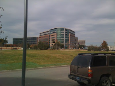
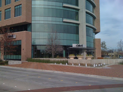
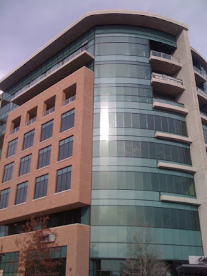
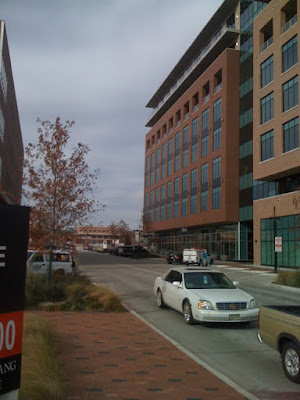
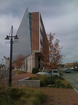
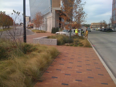
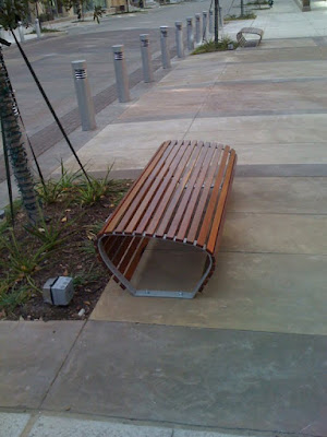
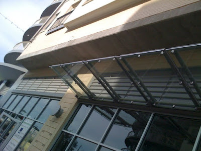
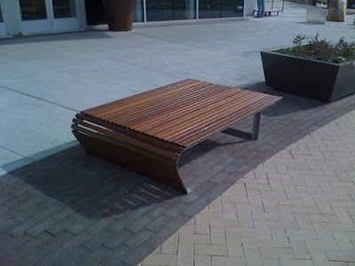
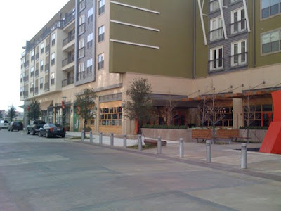
Imagery taken in December:
---------------------------
My last point is about the nearby Museum Place. As I stated, in my opinion it has excellent detailed architectural design and landscape architecture, but it doesn't yet feel like a place. With the efforts at the Cultural District, W. 7th, and Fort Worth's streetcar efforts, eventually it will. Like all cities throughout history that grew together, morphed, and coalesced, eventually it will all feel like one coherent place; a center close enough to downtown that provides a positive feedback loop with downtown Fort Worth, utilizing 7th street as the chains of the bicycle between pedals and spokes.
As of now however, the real story of all of this is that with its excellent detailed architecture and landscape design, Museum Place is held back by the street design around it.
Imagery: