


- A city is an economy embodied
- An economy is social and financial exchange
- In-person exchange is encoded in our DNA
- In-person exchange is always more beneficial than digital, but not always more necessary
- The internet is better as a tool aiding in-person exchange than it is a substitute.
- Car-dependent exchange networks and movement is effectively a tax of distance, infrastructure, and energy. Qualitatively and quantitatively.
- There is very little chance any economy can sustain itself willfully taxing itself unnecessarily.
- These dynamics take a generation or two to play themselves out, hence Mumford's quote: "necropolis is near yet no stone has yet crumbled."
Thursday, December 20, 2012
Bullet Points
I just wrote these down in my notes to help clarify my thoughts a bit, so I might as well post them. I accept them as defensible and acceptable truisms
Wherein Jeff Speck and I Have 99 Agreements, but This Ain't One
It probably doesn't come as a particular surprise to you that I agree with much of what is in Jeff Speck's book, Walkable City. In fact, much of it reads as if it was two years of this blog distilled into two hundred pages of factoids, statistics, and broader socio-economic points.
In the book, Speck outlines the "ten steps" towards more walkable cities (and the myriad of spinoff benefits). The first step is the most important, essentially to reign in various departments of transportation. Eventually, the book gets to step 4, which is "to let transit work." Speck uses Dallas and DART to convey his thesis that neighborhoods must be geared to be walkable around transit stations (no big surprise there).
However, it's when he gets to solutions for Dallas where it starts to fall flat. And that isn't a condemnation. I don't think many people outside of Dallas and DFW really get Dallas and the particulars of the issues. Rather, "Dallas," "Plano," "Arlington," "DFW," etc. are simply abstractions meaning the exact same thing. Say "Plano" to somebody in New York or DC and they'll likely think something entirely different than what we might think. Same with "Dallas." Though it must be said, I agree that Dallas and DFW are entirely too coercively car-dependent.
Problem 1 is where Speck says, "areas around transit have to be more walkable, more dense, etc." I'm paraphrasing, of course, but the point that this isn't the effort at least misses the broader point that the real estate market here already so favors transit areas that land costs have been so inflated as to price out most development (though all the points Speck cites from Yonah Freemark are right on).
The other issue is that we tend to think of transit as applicable across cities and that all transit is the same, ie a subway is the equivalent of DART, which is mostly elevated or at-grade. This is a critical point because elevated and at-grade lines disrupt local networks and walkability as much if not moreso than what the stations add. The real benefit for stations is a few blocks away, not right at stations, which is why I believe we've overvalued station areas, expecting high density, and high end development, yet it has yet to materialize simply because the numbers just don't work.
Problem 2 is the bigger one. Speck says we have to wait for gas prices to hit $10/gallon, which comes off as particularly magic bullet-y and in my opinion, incorrect. And the thing is, Speck obviously gets it, as the pages leading up to this point he's making similar points that I have about the need for Pigovian efforts which punish things that take away from the public good, in this case, driving, parking, etc.
However, 1) we can't afford to sit around and do nothing until gas prices become so punitive. As much as urbanists might like to believe it, there is no guarantee gas prices will hit such levels and in my opinion, no should we want to punish, but rather focus on amplifying the good aspects of urbanism and increasing its supply and thus affordability.
And 2) gas prices have little to no effect on behavior. Particularly in DFW. See the NCTCOG chart below tracking DART ridership with gas prices:
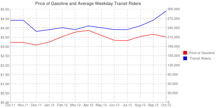
Change the dates on this handy little graphic to whatever you want and there is no discernible causality that rising gas prices lead to more transit ridership. In fact, it's just the opposite. When gas prices drop, ridership seems to drop as well, which I would suggest tells a broader tale about economic activity, particularly in relation to jobs.
OK, so gas prices don't affect transit ridership, but do they change vehicle miles traveled? Of course not as this nationwide chart shows:
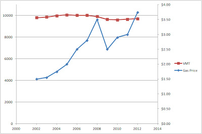
There you have it, a 267% increase in gas price and a 5% drop in VMT over the last ten years. And you could argue pretty persuasively that the drop in VMT had more to do with the recession than any fluctuations in gas prices. Instead, as gas prices rise, we just pay more to the Saudis and others.
Rising gas prices are and will be particularly punitive to DFW (and I worry they might be utterly, pervasively crippling, as in collapse on the level of Detroit or worse) due to the fact that DFW is a captive market. It's so overwhelmingly and coercively car-dependent due to the infrastructure that we've built and the mortgages many are trapped in "underwater," that we can't possibly adapt quickly enough to the volatility of gas prices.
The captive nature of the DFW market is only further calcified by the very few walkable areas in relation to demand. Meaning, it is cost prohibitive for the majority of the city even though being car independent for much of the city would be a massive financial incentive.
If we were to simply "wait for $10/gallon gas, surely there will be a tipping point where it triggers change in behavior. However, "tipping point" implies quick and sudden change. However, cities don't evolve nor adapt quickly. It takes a generation or two and it is always shaped by infrastructure. As the city won't be able to suddenly adapt to the tipping point, I suspect instead, people will leave, as the effective "tax" on transportation will slowly but surely erode the DFW economy's ability to sustain itself before we even hit that tipping point where price increases become intolerable (and as we lose out on talent looking for precisely these more walkable, and thus more interesting, more self-expressive, self-organized cities).
The bigger issue, and one Speck even points out, is that as long as we have the highway capacity it will be filled. And also, it is these highways through the center of the city (see the massive 18-wheeler accident on I-30 over the Trinity this morning) that disrupts and reduces the demand and desirability of close-in areas. Highway capacity has to be slowly but surely relegated to the edge of the city. Starting immediately.
I'd suggest nothing inside Loop 12 by 2040 or so. Here is where I point out that Paris city limits are nearly identical to I-30 to Loop 12 to the north. We can't simply wait around for gas prices, but instead we have to reduce highway capacity in and around downtown while replacing it with highly desirable supply of walkable urban housing. It's the only way to reverse the upside down supply-demand dynamic which currently favors the bleeding edge of development.
In the book, Speck outlines the "ten steps" towards more walkable cities (and the myriad of spinoff benefits). The first step is the most important, essentially to reign in various departments of transportation. Eventually, the book gets to step 4, which is "to let transit work." Speck uses Dallas and DART to convey his thesis that neighborhoods must be geared to be walkable around transit stations (no big surprise there).
However, it's when he gets to solutions for Dallas where it starts to fall flat. And that isn't a condemnation. I don't think many people outside of Dallas and DFW really get Dallas and the particulars of the issues. Rather, "Dallas," "Plano," "Arlington," "DFW," etc. are simply abstractions meaning the exact same thing. Say "Plano" to somebody in New York or DC and they'll likely think something entirely different than what we might think. Same with "Dallas." Though it must be said, I agree that Dallas and DFW are entirely too coercively car-dependent.
Problem 1 is where Speck says, "areas around transit have to be more walkable, more dense, etc." I'm paraphrasing, of course, but the point that this isn't the effort at least misses the broader point that the real estate market here already so favors transit areas that land costs have been so inflated as to price out most development (though all the points Speck cites from Yonah Freemark are right on).
The other issue is that we tend to think of transit as applicable across cities and that all transit is the same, ie a subway is the equivalent of DART, which is mostly elevated or at-grade. This is a critical point because elevated and at-grade lines disrupt local networks and walkability as much if not moreso than what the stations add. The real benefit for stations is a few blocks away, not right at stations, which is why I believe we've overvalued station areas, expecting high density, and high end development, yet it has yet to materialize simply because the numbers just don't work.
Problem 2 is the bigger one. Speck says we have to wait for gas prices to hit $10/gallon, which comes off as particularly magic bullet-y and in my opinion, incorrect. And the thing is, Speck obviously gets it, as the pages leading up to this point he's making similar points that I have about the need for Pigovian efforts which punish things that take away from the public good, in this case, driving, parking, etc.
However, 1) we can't afford to sit around and do nothing until gas prices become so punitive. As much as urbanists might like to believe it, there is no guarantee gas prices will hit such levels and in my opinion, no should we want to punish, but rather focus on amplifying the good aspects of urbanism and increasing its supply and thus affordability.
And 2) gas prices have little to no effect on behavior. Particularly in DFW. See the NCTCOG chart below tracking DART ridership with gas prices:
Change the dates on this handy little graphic to whatever you want and there is no discernible causality that rising gas prices lead to more transit ridership. In fact, it's just the opposite. When gas prices drop, ridership seems to drop as well, which I would suggest tells a broader tale about economic activity, particularly in relation to jobs.
OK, so gas prices don't affect transit ridership, but do they change vehicle miles traveled? Of course not as this nationwide chart shows:
There you have it, a 267% increase in gas price and a 5% drop in VMT over the last ten years. And you could argue pretty persuasively that the drop in VMT had more to do with the recession than any fluctuations in gas prices. Instead, as gas prices rise, we just pay more to the Saudis and others.
Rising gas prices are and will be particularly punitive to DFW (and I worry they might be utterly, pervasively crippling, as in collapse on the level of Detroit or worse) due to the fact that DFW is a captive market. It's so overwhelmingly and coercively car-dependent due to the infrastructure that we've built and the mortgages many are trapped in "underwater," that we can't possibly adapt quickly enough to the volatility of gas prices.
The captive nature of the DFW market is only further calcified by the very few walkable areas in relation to demand. Meaning, it is cost prohibitive for the majority of the city even though being car independent for much of the city would be a massive financial incentive.
If we were to simply "wait for $10/gallon gas, surely there will be a tipping point where it triggers change in behavior. However, "tipping point" implies quick and sudden change. However, cities don't evolve nor adapt quickly. It takes a generation or two and it is always shaped by infrastructure. As the city won't be able to suddenly adapt to the tipping point, I suspect instead, people will leave, as the effective "tax" on transportation will slowly but surely erode the DFW economy's ability to sustain itself before we even hit that tipping point where price increases become intolerable (and as we lose out on talent looking for precisely these more walkable, and thus more interesting, more self-expressive, self-organized cities).
The bigger issue, and one Speck even points out, is that as long as we have the highway capacity it will be filled. And also, it is these highways through the center of the city (see the massive 18-wheeler accident on I-30 over the Trinity this morning) that disrupts and reduces the demand and desirability of close-in areas. Highway capacity has to be slowly but surely relegated to the edge of the city. Starting immediately.
I'd suggest nothing inside Loop 12 by 2040 or so. Here is where I point out that Paris city limits are nearly identical to I-30 to Loop 12 to the north. We can't simply wait around for gas prices, but instead we have to reduce highway capacity in and around downtown while replacing it with highly desirable supply of walkable urban housing. It's the only way to reverse the upside down supply-demand dynamic which currently favors the bleeding edge of development.
Thursday, December 13, 2012
Why Grids Matter and We Should Recreate Them At All Cost (Strictly for the ROI)
I have written before about the difference between dendritic and reticulated grids. However, that was highly theoretical and still lacking in real world justification. Here I'm going to try and provide further justification for the grid in a more applicable manner.
First, we have to revisit the differences between reticulated networks and dendritic ones:

A dendritic system is defined by a branching structure that funnels movement in one direction. Whereas a conventional grid provides a multiplicity of routes. The key defining factor is choice. Think about this from where you live and you're on your way to work or to pick up the kids or to get a gallon of milk. How many routes can you take? What if there is a wreck along the way? How many different modes of travel are quick and convenient?
There is quite a bit of talk about the emergent nature of cities as complex systems, but few really understand the applicability to how we design our cities and the dynamics of the process. What we have to understand is that emergence implies a second level of organization that is largely beyond our control. Why? Because we can only 'design' the first level of organization, whether it is a building or a road. Because designers are only one person or group working on one problem. The second order of 'design' happens when everybody else decides how to use the system. That can't be designed en masse, only nudged in certain directions depending upon how well we understand the dynamics of this emergence.
For example, the wave in a stadium is simply the act of standing up, waving your arms, and sitting down. Whether everyone else decides to do it or not is entirely up to them. Now amplify that a few million times in complexity for all the actions or inactions involved in every citizens daily life. All of those actions then determine the form of the city, organized loosely around the first order of things that we can actually design. You might say the first order is the infrastructure of the city and the second order is the real estate market. The market can't really be 'designed' per se, but it can be shaped and given order. Those that try to fully design the second order, whether it's Radiant City, Brasilia, Masdar, or any masterplanned community, rather than simply designing the platform for life to exist on its own, invariably fall short.
It can be nudged in one of two directions by the two systems I've illustrated above, dendritic or reticulated. Here is the difference that I've described before: dendritic systems spread everything out while grids concentrate. The reason is because dendritic systems concentrate the bad and disperse the good. On the other hand, complex highly interconnected grids concentrate the good (the sociopetal) and disperse the bad (sociofugal). Why?
It all comes down to choice. Grids, due to the multiplicity of routes available, empower choice. You can go many different routes depending upon the needs of the individual trip and can calibrate each trip then to the dynamics at the time. An accident in one area, re-route.
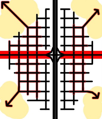
Amplifying this aspect, is that in dendritic systems the roads get bigger and bigger and bigger, funneling more traffic into certain corridors while emptying out all of the other. It makes these 'trunk' roads even more undesirable. Unfortunately, business needs the traffic of those roads.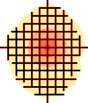
The grid, by being meritocratic, concentrates real estate value at the most desirable places. Value is indicated by and proportional to traffic (of all modes).
Dendritic systems disperse and discourage both choice of route and mode of travel. By dispersing people and concentrating traffic it becomes a fundamentally car-dependent system whether it is intended or not.
With the grid, because the capacity is shared throughout, it allows all the individual roads to be smaller and therefore be less car-oriented. By being less car-oriented it allows even more choice, not just of route, but also of mode. The citizen is even more empowered, thus making for a smarter, more adaptable system and city. Density of movement and population is an indicator of desirability and thereby even more attractive, comprising the third multiplier effect.
Because the grid empowers choice, it becomes fundamentally meritocratic by place. We are drawn to the more desirable places and repelled from the less desirable places, thereby 1) bringing a complex self-organizing order to the real estate market, density and value go where they want to and 2) provide an upward impetus to the real estate market. Want your land to be more valuable? You have to make it more desirable. Whereas in the dendritic system the fundamental dynamic is about being less bad, less sociofugal. The design response is then all about ameliorating and buffering the bad things rather than multiplying, amplifying and accentuating the good.
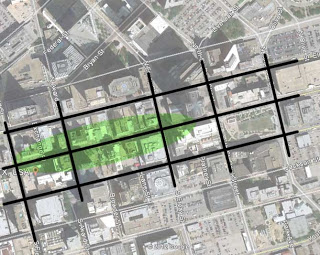
An admittedly imperfect grid of downtown Dallas (blocks are too big as are the thoroughfare plan-coerced arterials), still concentrates and centralizes the desirable along Main Street.
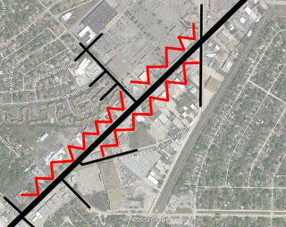
Arterials that clip the grid and concentrate vehicular traffic instill a tension. It draws businesses due to the traffic which then have to defend or buffer themselves from the undesirability of place. The dispersing tendency this has on the real estate market then drops land value, which in turn drops the impetus to put any money or design quality into place, while further empowering cannibalization and decay, destabilizing places.
Same effect only larger with highways, the trunk which arterial feed. At first the real estate market was attracted to the traffic counts only to realize their access and interconnectivity is poor. What was first office high-rises and hotels eventually degrades to find its true level, often gas stations, drive thrus, roadside motels, etc.
In conclusion, due to the lack of choice inherent in the hierarchical road classification system and their standards, the real estate market is put into a perpetual race to the bottom. Those that dare create something urban-esque, end up failing if they don't recreate and restructure a complex grid of highly interconnected movement that empowers choice of mode and route. See: Victory for a development that provided urban supply with suburban demand (via its infrastructural interconnectivity). Vertical cul-de-sacs set on horizontal cul-de-sacs. And now you know why it's mostly empty.
First, we have to revisit the differences between reticulated networks and dendritic ones:
A dendritic system is defined by a branching structure that funnels movement in one direction. Whereas a conventional grid provides a multiplicity of routes. The key defining factor is choice. Think about this from where you live and you're on your way to work or to pick up the kids or to get a gallon of milk. How many routes can you take? What if there is a wreck along the way? How many different modes of travel are quick and convenient?
There is quite a bit of talk about the emergent nature of cities as complex systems, but few really understand the applicability to how we design our cities and the dynamics of the process. What we have to understand is that emergence implies a second level of organization that is largely beyond our control. Why? Because we can only 'design' the first level of organization, whether it is a building or a road. Because designers are only one person or group working on one problem. The second order of 'design' happens when everybody else decides how to use the system. That can't be designed en masse, only nudged in certain directions depending upon how well we understand the dynamics of this emergence.
For example, the wave in a stadium is simply the act of standing up, waving your arms, and sitting down. Whether everyone else decides to do it or not is entirely up to them. Now amplify that a few million times in complexity for all the actions or inactions involved in every citizens daily life. All of those actions then determine the form of the city, organized loosely around the first order of things that we can actually design. You might say the first order is the infrastructure of the city and the second order is the real estate market. The market can't really be 'designed' per se, but it can be shaped and given order. Those that try to fully design the second order, whether it's Radiant City, Brasilia, Masdar, or any masterplanned community, rather than simply designing the platform for life to exist on its own, invariably fall short.
It can be nudged in one of two directions by the two systems I've illustrated above, dendritic or reticulated. Here is the difference that I've described before: dendritic systems spread everything out while grids concentrate. The reason is because dendritic systems concentrate the bad and disperse the good. On the other hand, complex highly interconnected grids concentrate the good (the sociopetal) and disperse the bad (sociofugal). Why?
It all comes down to choice. Grids, due to the multiplicity of routes available, empower choice. You can go many different routes depending upon the needs of the individual trip and can calibrate each trip then to the dynamics at the time. An accident in one area, re-route.
Amplifying this aspect, is that in dendritic systems the roads get bigger and bigger and bigger, funneling more traffic into certain corridors while emptying out all of the other. It makes these 'trunk' roads even more undesirable. Unfortunately, business needs the traffic of those roads.
The grid, by being meritocratic, concentrates real estate value at the most desirable places. Value is indicated by and proportional to traffic (of all modes).
Dendritic systems disperse and discourage both choice of route and mode of travel. By dispersing people and concentrating traffic it becomes a fundamentally car-dependent system whether it is intended or not.
With the grid, because the capacity is shared throughout, it allows all the individual roads to be smaller and therefore be less car-oriented. By being less car-oriented it allows even more choice, not just of route, but also of mode. The citizen is even more empowered, thus making for a smarter, more adaptable system and city. Density of movement and population is an indicator of desirability and thereby even more attractive, comprising the third multiplier effect.
Because the grid empowers choice, it becomes fundamentally meritocratic by place. We are drawn to the more desirable places and repelled from the less desirable places, thereby 1) bringing a complex self-organizing order to the real estate market, density and value go where they want to and 2) provide an upward impetus to the real estate market. Want your land to be more valuable? You have to make it more desirable. Whereas in the dendritic system the fundamental dynamic is about being less bad, less sociofugal. The design response is then all about ameliorating and buffering the bad things rather than multiplying, amplifying and accentuating the good.

An admittedly imperfect grid of downtown Dallas (blocks are too big as are the thoroughfare plan-coerced arterials), still concentrates and centralizes the desirable along Main Street.

Arterials that clip the grid and concentrate vehicular traffic instill a tension. It draws businesses due to the traffic which then have to defend or buffer themselves from the undesirability of place. The dispersing tendency this has on the real estate market then drops land value, which in turn drops the impetus to put any money or design quality into place, while further empowering cannibalization and decay, destabilizing places.

Same effect only larger with highways, the trunk which arterial feed. At first the real estate market was attracted to the traffic counts only to realize their access and interconnectivity is poor. What was first office high-rises and hotels eventually degrades to find its true level, often gas stations, drive thrus, roadside motels, etc.
In conclusion, due to the lack of choice inherent in the hierarchical road classification system and their standards, the real estate market is put into a perpetual race to the bottom. Those that dare create something urban-esque, end up failing if they don't recreate and restructure a complex grid of highly interconnected movement that empowers choice of mode and route. See: Victory for a development that provided urban supply with suburban demand (via its infrastructural interconnectivity). Vertical cul-de-sacs set on horizontal cul-de-sacs. And now you know why it's mostly empty.
Wednesday, December 12, 2012
East Atlanta Renaissance: All due to East Lake Golf Club
There has been quite a bit of debate in twitter-verse and media world regarding the proposed Trinity Forest golf course. I'm on record as saying, it's a perfectly fine idea for land that isn't terribly useful for much else. And, more importantly, it is great to swipe the Byron Nelson, which seems to be inevitable. I hesitate to use the second worst phrase in Dallas development lexicon, "game changer" (behind "world class"), but it is the Byron Nelson that makes this deal even worthwhile.
However, the cheerleading for economic development as the next magic bullet for South Dallas is over the top, politically cynical, and disingenuous. Even the mayor has been backing away from the "hundreds of millions" rhetoric. Instead, the Morning News editorial page doubled down, citing pretty superficial census data. "Hey look. Income is up around it."
Here are the facts. East Lake Golf Club is over one hundred years old. It's four miles from downtown Atlanta. East Atlanta had fallen into decay and blight through the 70s, 80s, and 90s, like every downtown adjacent area in the Sun Belt. The golf course was then renovated in the 90s. After which, the course began landing more PGA tournaments.
The kind of money needed to renovate a golf course to those standards certainly creates some spin-off development, but is it really responsible for the rise of East Atlanta?
To better make the analogy of Atlanta to Dallas, the downtowns are fairly similar, but Atlanta's then grows directly into Midtown, which is their equivalent to uptown. Both of which have seen quite a resurgance over the last twenty years. The major difference however is that downtown and midtown Atlanta then both blend into neighborhoods toward the east without barrier, ie freeways, making investment moving eastward from downtown and midtown the obvious direction for the next generation of investment and development.
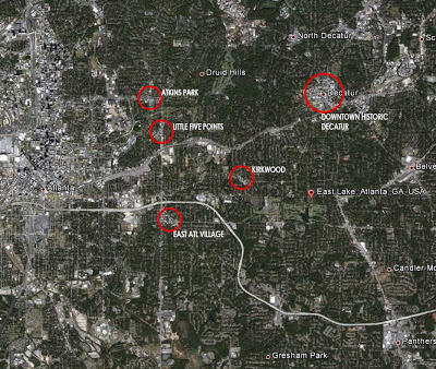
On the map, you can see downtown to the left (middle) and midtown to the top left. East Lake Golf Club has the google earth pointer. I have then circled five areas of East Atlanta that have seen a resurgence in the last ten years: Atkins Park, Little Five Points, Kirkwood, East Atlanta Village, and Downtown Decatur. Each of these serve as neighborhood centers of gravity for commercial services, amenities, and primarily social exchange (particularly for younger people, ie bars, restaurants, and cafes).
It is important to note that all of these areas (except for Decatur, which is a large historic downtown that Atlanta's growth absorbed long ago) are west of East Lake. Despite the City of Atlantas efforts to revitalize areas East of East Lake, with significant streetscape expenditures (particularly along Candler Road) it really hasn't happened. If East Lake was the driver, the revitalization would likely revolve around it rather than what it does, which is expand from downtown and coalesce around streetcar sub-centers.
It is critical to note that the rise and investment in these areas has mostly occurred in the last ten years, in that the development model is significantly different than what occurred around East Lake, which is more conventional suburban in nature. Meanwhile, these historic streetcar suburbs are more about small-scale infill of existing areas. The development is much more walkable and urban and it blends into the surrounding areas. They are very similar to Greenville and Bishop Arts, both in their scale and feel, but also the young professional / hipster demographic they've attracted. A demographic which is drawn to these places both for the character, towards their similar peer cohort, and the cheap land and attractive, small 30's-ish housing stock left behind by the hollowing out of Sun Belt cities.
Furthermore, when looking at the census data, the median income cited by the Morning News around East Lake is indeed in the 40K range all around the golf course. However, the census data shows greater improvement around these revitalized neighborhood centers, mostly in the 50s and 60s. Furthermore, the range of historic and new housing stock is similar throughout the area, between 200,000 and 350,000 with no discernible difference by location or proximity to the golf course, but rather by size of the individual dwelling and its condition. It is also important to note that these areas actually serve the demographic of the area. A private golf course isn't an amenity for the demographic that the Morning News is suggesting it is responsible for. However, these walkable centers do serve the demographic.
Timing and location suggests that the rise of East Atlanta had more to do with broader demographic patterns favoring a shift back towards cities than re-investment in a golf course. And because of that, we have to relate these lessons back to Dallas and the Trinity Forest course, which is 8 miles away and not set within existing neighborhood fabric. Instead, as with East Lake, there will be some auxiliary and spin-off development associated, however we can not attribute broader regional gains to any singular investment such as a golf course.
HIVEMIND: ACTIVATE. Do we need an option 10?
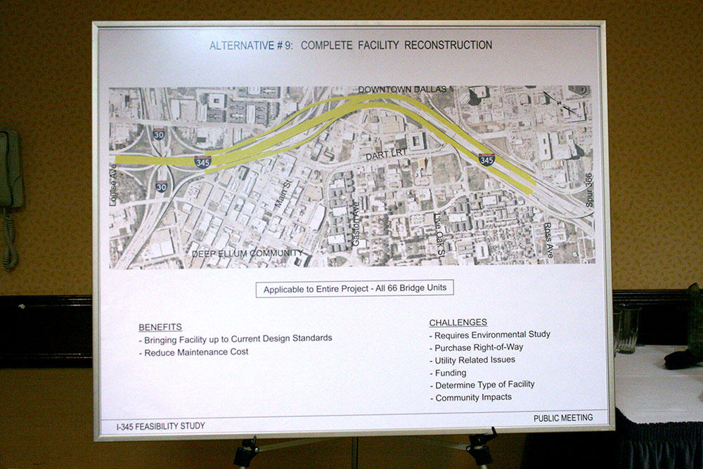
World, you tell me. Does option number 9 sound like a tear-down and reconstruction of the grid? The language is so vague that I interpreted it to be a tear-down and rebuild of another highway, "but to modern standards." And to modern standards, that surely means 1980's finest. Modern standards to me also might be interpreted as, "complex grid of high quality, walkable, urban streets."
Also, "Purchase Right-of-way" could mean land sales of right-of-way to private investment (possibly through an intermediary like City of Dallas or a to-be-established Development Corporation, focused strictly on the redevelopment of the area (preferred). Or, it could mean that in order to bring the "facility up to modern standards," requires further ROW purchase from TxDOT to widen and expand the capacity of the highway, in order to "improve level of service for the 160,000 cars/day. As we know, that will simply mean that it will move 200,000+ per day instead and we're all worse off for it.
People are telling me this is the option I'm looking for, but I don't buy it. There is still a lot left to be determined, but we must ensure that the scenarios properly factor all possible solutions and benefits for the city of Dallas and the nearby neighborhoods including potential private investment and new tax base. To which, there is only one option that would incent any new investment. And that requires the removal of the highway and the replacement with a legitimate grid of streets and blocks.
Tuesday, December 11, 2012
Planners Planning to Whisper Sweet Nothings
So I was at the IH-345 soiree where I was able to hobnob with bigwigs like Wilonsky. I was hoping/expecting it to be more like the Trinity Toll Road public hearing, though far less contentious. The whole highway through a park thing tends to rile people/politicians up a bit more than the rebuild of an existing highway (even though the potential economic impacts are much greater with 345...but I'll get to that).
At the Trinity hearing, the engineers
Alas, I'll leave this with one little tidbit of a study I hope to expand with time. The City of Dallas has 40.3 times the amount of highway lane miles per capita than does London.
Automated Trading
You know how one of the major causes of the economic collapse on Wall Street rippling throughout the globe came from the high-frequency trading by computerized algorithms repeated over and over and over and over and over and over and millions of more times over, each time siphoning off fractions of wealth but creating no new or real wealth, but instead a hyper-inflated global balloon of helium filled fake wealth?
Well, that's sort of how transportation engineers, albeit much more slowly are steadily but surely running our cities off a cliff in the pursuit of the flying purple dragon, "congestion relief." They have formulas and standards repeated for every single roadway across the country and invariably the formula always says, "widen it." Unfortunately, the formula takes very little into account let alone what then happens to urban form via the real estate market due to the ever-widening and funneling of cars into particular state-owned corridors. And more particularly, the very purpose of cities. What they do is run the formula over and over and over and over again until there is no city left. No city? No congestion. Problem solved.
Lewis Mumford wrote, "the purpose of transportation is to bring people and goods to places where they are needed, an\d to concentrate the greatest variety of goods and people within that limited area, in order to widen the possibility of choice without making it necessary to travel. A good transportation system minimizes unnecessary transportation, and in any event, it offers change of speed and mode to fit a diversity of human purposes."
What he's saying is that transportation has to be subservient to the purpose of the city and to do so it must maximize efficiency. Efficiency of course isn't through speed, which spreads us out as Ivan Ilich noted, but proximity and propinquity, the arrangement of our daily needs for social and economic exchange around us. Because the city is an extension of us. A tool facilitating our need for social and economic exchange to better quality of life. But social and economic exchange cannot occur without convergence, aka coming together, aka congestion. Even if you were home sick or a recluse, to get food or water or have friends stop by, somebody still has to move, to deliver, to drop by.
Coming together is what the city enables. It's only congestion if it's entirely by car. We think it's our choice but the infrastructure that separates and divides allows not for choice, but coercion. The smart, efficient, livable city of which Mumford speaks brings us together by our very own choice. It empowers us. TxDOT is fighting against congestion and by extension fighting against human nature and the nature of cities as machines of convergence, exchange, and opportunity. At some point, cities have to stand up for themselves. And as it turns out, IH345 through downtown Dallas is the perfect time to do so.
Coincidentally, there just so happens to be a public hearing tonight on that very stretch of highway at 6 pm. If you care about Dallas, and ya know, its ability to attract talent and cultivate a true tax base without the burden of TxDOT's unnecessary infrastructure, I recommend you attend:
Wyndham Dallas Love Field Hotel, 3300 W. Mockingbird Lane, Dallas, TX 75235
Friday, November 30, 2012
Road Diets: Still Winning
Awards that is (in this case, a California planning group Moule & Polyzoides won the EPA's top award), but far, FAR more importantly, the areas that implement them are experience significant triple bottom line gains. The latest example is the BLVD project in Lancaster, CA, which transformed a five lane arterial (which had bulldozed its way through the historic Main Street to make way for more traffic and only ended up killing the place) consisting of 2 travel lanes in each direction and a central turn lane into one travel lane in each direction, one row of parallel parking on each side, and a central parking median for angled head-in parking with special plaza-like pavement.
More importantly, is the data (which really, should be what drives awards rather than the ideology that typically does), which comes directly from the City of Lancaster itself:
"Shutup with your observable statistics! We've got PROJECTIONS that say we gotta move cars and we gotta move'em quickly. Or Else!"
"Or else what?"
"Congestion!"
"Well, yeah. That's what we want and need for businesses to thrive and attract investment."
All that private investment from simple urbanization of inappropriate and disconnective suburbanized infrastructure. A novel concept indeed. Maybe some day they'll learn that magic bullets of high cost/low yield ventures are the way to go.
Here is some imagery:
That's obviously during a special event and I hate being disingenuous, suggesting, like an architectural rendering all of these people actually exist on a normal day (because after all, true urbanism is about the every day, not event planning):
This looks like a typical day and I wonder the nature of the parking. Is it free? Do employees take up all the best spots forcing visitors to circle? Either way, the amenitized central planning median in conjunction with narrowed travel lanes and pedestrian refuges at the crosswalks make it a more tethered, and therefore better interconnected, street.
The Before:

The After:

More importantly, is the data (which really, should be what drives awards rather than the ideology that typically does), which comes directly from the City of Lancaster itself:
· The BLVD has attracted 49 businesses since late 2009.
· Revenue from the downtown area is up 96% compared to the same period in 2007, the year before revitalization efforts began. (The Downtown Lancaster Specific Plan was adopted in 2008.)
· The project cost was approximately $11.5 million for a per-block cost of approximately $1.27 million.
· While Lancaster’s assessed property valuation fell 1.25% overall from 2011 to 2012, property values in the downtown area rose 9.53%.
· Private investment is estimated at $130 million.
· Over 800 permanent jobs have been created, in addition to approximately 1,100 temporary construction jobs.*
· The project has generated an estimated $273 million in economic output.*
· Just over 800 housing units have been constructed or rehabilitated.
· Over 116,000 square feet of commercial space has been constructed or rehabilitated.
· New public amenities include American Heroes Park, a 13.5-acre, $7 million facility, and the Lancaster Museum of Art & History (MOAH), a three-story, 19,246-square-foot complex.
· The overall number of traffic collisions has been cut in half, while injury-related collisions have plummeted 85% as a result of the new streetscape and traffic pattern. (These figures compare the two-year history prior to the transformation with the two years following.)
"Shutup with your observable statistics! We've got PROJECTIONS that say we gotta move cars and we gotta move'em quickly. Or Else!"
"Or else what?"
"Congestion!"
"Well, yeah. That's what we want and need for businesses to thrive and attract investment."
All that private investment from simple urbanization of inappropriate and disconnective suburbanized infrastructure. A novel concept indeed. Maybe some day they'll learn that magic bullets of high cost/low yield ventures are the way to go.
Here is some imagery:
That's obviously during a special event and I hate being disingenuous, suggesting, like an architectural rendering all of these people actually exist on a normal day (because after all, true urbanism is about the every day, not event planning):
This looks like a typical day and I wonder the nature of the parking. Is it free? Do employees take up all the best spots forcing visitors to circle? Either way, the amenitized central planning median in conjunction with narrowed travel lanes and pedestrian refuges at the crosswalks make it a more tethered, and therefore better interconnected, street.
The Before:
The After:
Thursday, November 29, 2012
Spinning in Circles at the End of a Long Metaphorical Cul-de-Sac
Not to be naive, but now I know why politicians distill their message into carefully engineered empty soundbites.
As you may or may not have seen, WFAA did a bit on the pending IH-345 feasibility study and our version that removes the elevated freeway that TxDOT in their infinite wisdom (and debt) will ignore. I'd post the video but it's not worth it. You can find it here with the much better written portion. I usually don't watch myself on TV because the entire time I think about what I could've or should've said differently. This time I did however watch it and was disappointed the fifteen minutes of dialogue was reduced to a seemingly reactionary, "tear it down!"
Here is what I hoped would be conveyed:
How did you get started on this?
Well, a developer friend and I were talking about the various downtown initiatives and critiquing what was happening, that the underlying problem of downtown wasn't being addressed in the downtown revitalization efforts. And that is that the real estate market of downtown was upside-down, that demand was too low and land costs were too high as landowners of these surface parking and vacant lots all around us (the highest and best use specifically because of the freeway) look for a Museum Tower, skewed-market kind of payday. So we have to address the core problem which is dropping land costs while increasing demand. Demand is low precisely because of this road that is effectively publicly owned land by an institution drowning in debt that should be looking to offload assets rather than increase cost burdens.
Why?
We, as a city, have to ask ourselves what is the purpose of the city? What is the purpose of transportation within a city? What do we want it to be? And does TxDOT's mission align or contradict with that? Cities are a machine for interaction. They facilitate social and economic exchange. And do so as safely and efficiently as possible with regard to the mode of transportation, the degree of connectivity, and the spatial effect transportation has on real estate (urban form).
And to do so it's necessary to come together, to converge, to create congestion. Congestion that TxDOT tries to fight in their costly Sisyphean War. You can't defeat congestion because congestion is inherent to city processes. You can only determine what kind of congestion you want, which is like cholesterol, the good kind that makes the system more healthy, or the bad kind that slowly kills. Car congestion or diversified transportation, which is ultimately (as long as densities aren't too extreme) not really congested at all.
When you look at this highway what do you see?
I see a crumbling artifact of 1950's and 60s era planning that, it too, is crumbling. There is really no point to repairing it or rebuilding it. There is no more economic development to be garnered from just rebuilding it. What economic development did occur, happened mostly outside of downtown anyway. What I see is a giant barrier to downtown and Dallas as a whole's next step in evolution to a better, more livable, more fiscally stable and sustainable 21st century city.
You know people are going to say, "that's crazy," right?
It's actually crazy that it was even built in the first place when you consider that everything downtown leaders want in downtown (housing, streetcar, theaters, etc) were removed to make way for it. And since then it has simply corroded the urban fabric all around it. Which is ironic because the structure of this highway is literally corroding from within. Good luck to all those driving on it right now.
Why wouldn't they do this?
Because TxDOT will tell you that they need to move the 160,000 vehicles a day through this corridor. But that's the funny part, those cars are only there and in those numbers precisely because of the highway being here. The real estate market adapted to the highway by moving further out and becoming more car dependent. In turn, it helped gut the tax base locally, in downtown and in Dallas in general.
The thing is most of the cars on that road above us aren't coming into downtown, it's regional traffic conflicts with the local movement patterns, causes "congestion," pollutes the air, and generally makes it intolerable and undesirable to live or be near. Meanwhile, much of East Dallas is crippled by disinvestment and decay precisely because the street grid is 250,000 cars per day UNDER capacity. That excess capacity combined with moving regional trips to loops 12, 635, and 190, increased DART ridership, and ample opportunity for more walkable urban neighborhoods absorbs more than the entirety of the 160,000 trips per day.
So if you could boil it down to one statement, what would you say?
I'm interested to see the costs of the various TxDOT plans, because we calculated that for less money than the cost of the Klyde Warren Park, we could open up 180-acres of land for new development on this 245-acre area which currently only has $19 million in improvements on the entire area and generates only $3 million per year for the city in tax revenue (and that's just property tax revenue as there is little to no economic activity occurring on this land).
Instead, we can spend $60-65 million to remove it, use the 4 TIF districts in place to restitch the urban grid, generate over $4 billion in investment for the city over fifteen years after demolition, and bring in $100 million per year in tax revenue for the city of Dallas. Money that would build several new parks, streetcar lines from West End to Lower Greenville and downtown to Deep Ellum
This is a no brainer that would be the most important thing Dallas could do to compete as a 21st century city for the next fifty years. But you tell me if there are any brains at TxDOT or in leadership positions. We could use some brains, courage, and a heart. Where's the wizard of Oz when we need him?
Tuesday, November 27, 2012
1945 Network Model vs Today: Or How I learned Why Dallas Moved Northward


These were asked for at a similar scale and here they are, the space syntax network integration models for Dallas 1945 (above) and Dallas of today (below). Note: the Dallas of today isn't finished, nor does it include the entire metroplex, which may or may not effect the model. If you're unfamiliar with these network integration models, they are in effect heat maps of street networks. The most integrated show up as red areas, which have been statistically shown (in more urban cities) to correlate with increased density, real estate, value, foot traffic, as well as reduced crime.
What is clearly apparent is how the red areas shifted northward with the introduction of the freeways and the effect the freeways then had upon growth towards the "favored quarter," in Chris Leinberger's speak, thus creating a self-fulfilling vicious circle of northern expansion and decentralization. And that's fine, I suppose, but what's more important is the LOSS of value in and around the core.
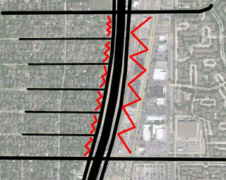
As I've said before, highways take land at the edge from a hypothetical value of 1 and improve them to 2. There is a profit model built-in there. Meanwhile, the intra-city highways take downtown land from a value of 10 to a similar value of 2 (as we saw in our highway 345 study which shows $77,500 in improvements (ie buildings) per acre. The effort to reduce congestion creates anti-city, by its very purpose. And we end up with anti-city at the edge (sprawl) and anti-city in the core (except for a few small pockets). See the walkscore heatmap:
I've also said before the horrible irony is that downtown developers were building the biggest buildings, the downtown high-rises at the same time that state and federal monies were pumped into highways thereby sapping the demand for all that new supply.
Assemble the Troops: IH-345 Feasibility Study
As you may know, a developer friend and I put together a study and plan to tear out IH-345. This is the section of highway you might consider the extension of Central Expressway past downtown separating downtown from Deep Ellum and the rest of East Dallas. You can find the presentation for that study here. The first half or so is all the background theory supporting the concept and you can skip right past that to the juicy details at the end showing what kind of economic development potential exists, where the traffic goes, and all the new opportunities for walkable urban housing (including affordable housing), and new downtown adjacent population and tax base would come of such a plan.
(Also, here are two posts where I show what happens to the lost traffic that 345 currently moves:
part 1
part 2)
What's funny is, we submitted several FOIA requests to see if TxDOT had anything in the works regarding this section of highway as we knew it was structurally deficient, the things that happen when elevated, reinforced concrete structures hit about 40 years old, as this road is. However, we never received any responses until Gabe, the creator of the facebook page on Tearing out 345 came across the public meeting announcement for a feasibility study of IH-345. It's December 11th out near Love Field, which is kind of bizarre, in that you'd think you would have it on-site or nearby (unless of course they don't want a big turn-out, which is my cynical side talking).
At this point, we have no idea what options are under consideration. However, we can be pretty confident in two things: 1) that the viaduct is structurally unsound, and 2) this will be used as an opportunity to "improve" the section of highway and "reduce congestion," which as you know is utter bunk. The very nature of a city is about congestion, of people coming together for social and economic exchange. Attempting to reduce congestion is 1) throwing the baby out with the bathwater (the city as a platform of economic growth and improved quality of life), and 2) chasing your tail, due to our very nature as humans and cities as a human investion to facilitate the above. We want to come together. We need to come together.
The only real question to ask is, what kind of congestion do we want? The good kind, which provides tax base and populates businesses and is desirable to live near, thus turning the real estate market inward? Or the kind that is entirely car-based, is on highways, sucks the life from neighborhood streets, is unsafe, and moves the real estate market ever outward?
There is no downside to a tear-out that not only pays for itself, but through land sales from opening up right-of-way and increased tax base, can pay for just about every other pet project in the city. There is however, downside to presumably every other option that will be presented.
----
Oh, and here's a fun/stupid study from the San Francisco Federal Reserve Bank showing that federal highway grants are good for short-term economic growth. Wow! Who'da thunk dumping free money into an area as well as temporary jobs and short-term real estate deals wouldn't? Of course, as we know nothing is more expensive than free. Hence, their leaving out any long-term implications (note the graph stops at year 10)
Friday, November 16, 2012
The Invisible Hand, Invisible Arm, and Invisible Brain of Cities
.JPG)
(image of the two walls lining the highway exit ramp I witnessed two little kids climbing as they moved from parked car to the playground at the deck park yesterday.)
I've been wanting to post this for a while since it is the most succinct way/analogy I can think of to explain the nature and dynamics of cities. It involves the invisible hand (the real estate market), the invisible arm (transportation), and the invisible brain (government/policy) behind it all.
There is a direct correlation here with systems theory I often cite (as cities are little more than highly fractalized complex systems), in terms of the three primary components of complex systems: elements (the most visible and least important), connections (kinda like transportation, huh?), and purpose (it's reason for being).
It is common when examining systems to focus on what is most tangible, the elements, because they're the simplest to understand. It's also how to get cities entirely wrong. This is what I call cosmetic urbanism. It confuses labels and things with the actual process of urban dynamics, morphology, and emergence, i.e. saying we need "mixed-use" without having the proper soil to cultivate into existence as the natural by-product of rational choice.
What results is potemkin villages and failed real estate deals. There are plenty of examples all over the city. Shopping sprees for jewelry buildings and bridges, nor plastic surgery of deck parks solve the underlying problems. Those lay within the invisible arm and invisible brain. The connections and purpose of the system.
And today, I got the perfect opportunity when a friend posed a question via email about the latest news that the "Horseshoe" project, a $750 million dollar highway rebuild of the downtown mixmaster, has been greenlit. It was actually more of a comment than a question, in that he mentioned the news to his significant other who was astonished when he told her that highway expansion only solves traffic temporarily and that it will inevitably become congestion.
There is no expanding our way out of the mess, because in effect (and in addition to what is written below) the intra-city highway network actually reduces overall system capacity. More streets are left empty as it fills up and the movement patterns become more regional, more highway-based. And an empty street is far more pernicious than a congested one.
But I was fascinated, not so much by her disbelief, but rather the successful of the rhetoric surrounding highway building. Listen to any transportation person. They conflate widening with "improvement." And we assume these people are experts so we trust them. Of course, their only expertise lies in road building. The question remains, "to what end?"
Here is an edited version of my response for popular consumption (with some relevant quotes from Mumford sprinkled in):
Yes, I did see the news. Wick Allison retweeted my joke yesterday that we're spending $750 million to "improve" this highway and move 450,000 cars per day, meanwhile Champs Elysees moves that many pedestrians per day yet THEY'RE the socialists. I went on to add that the real estate value along the two roads in relation to the infrastructure spent is probably close to inverse, ie if real estate value to infrastructural costs along Champs Elysees is 10:1 or whatever, then along [insert any highway] it's 1:10. Over time, this ratio becomes exponential. In both directions.
Point being, of both this specific example and of transportation policy/design/funding in general, is that real estate is the invisible hand but transportation is the invisible arm that shapes it.
The simple concept is induced demand and it is pretty well understood at this point, but ignored by politicians who want to bring in "jobs" aka federal spending (because THAT's sustainable - bringing in temporary jobs locally to move people out of your city. See: Detroit). A study from Brown University showed that for every highway that is built in a city (aka intracity as opposed to intercity, ie Autobahn) there is an 18% population loss associated to the core city. Similarly, a study from University of Toronto proved a 1 to 1 relationship in highway lane miles to average citizen vehicle miles traveled. Meaning, if you double freeway lane miles in a city over a 20 year span, the average citizen will drive double the amount. You're driving more, thus the induced demand from the very construction of the transportation network. We're 'nudged' into 'loving our cars' unwittingly, or what I call dependence, which isn't really love within any metaphor.
"By pushing all forms of traffic onto high speed motor ways, we burden them with a load guaranteed to slow down peak traffic to a crawl; and if we try to correct this by multiplying motor ways, we only add to the total urban wreckage by flinging parts of the city ever farther away in a formless mass of thinly spread semi-urban tissue."
The specific numbers aren't as important as the implication, that as intracity highway networks grow, population settlement patterns are displaced outwards, further apart and less efficiently. Compare all of your trips for daily needs to say, somebody in Barcelona. Whose is safer? Whose is more enjoyable? Whose is shorter and more efficient thereby exerting less energy and in turn, placing less of a 'tax' on the citizen to meet their needs (and that's before even getting into the actual cost of building and maintaining the infrastructure).
The reason is because highways fundamentally shift the real estate market outward, they subsidize driving (no tolls, user fees ie gas taxes cover only half the cost, artificially deflated gas prices) as well as real estate onto ever cheaper (further out) land by making driving temporarily easier. Then everybody moves further out and the roads fill up as more and more people are driving more and further. They're effectively 'induced' into it. That's only one half of the equation, the other half is that freeways deflate real estate values along them because they're unsafe, noisy, smelly, and disconnective to local movement patterns. The highest and best use is parking lots, gas stations, and drive thrus.
"Under the present suburban regime, every urban function follows the example of the motor road; it devours space and consumes time with increasing friction and frustration, while, under the plausible pretext of increasing the range of speed and communication, it actually obstructs it and denies the possibility of easy meetings and encounters by scattering the fragments of a city at random over a whole region."
Intracity highways take land outside of town that has a value of 1 and makes it a 2. There is a profit margin for developers, but comes at a steep price to taxpayers by way of infrastructure to dispersed population. On the other hand, it takes in town land that has a value of 10 and similarly transforms it into a 2, disinvestment. See virtually every downtown in America. And to bring our downtown's "back" we're heavily subsidizing any and every magic bullet we can think of, until finally settling on the right one, which is to bring people back, residential, by also heavily subsidizing it. But that did nothing for the actual demand equation which is still at a 2. If there isn't a profit in it (as the public's ability to subsidize infill diminishes), infill development, ie urbanism, won't be the modus operandi for the real estate market.
"For when one conquers space one also increases the populations to whom that distant space is accessible. The prospective net gain is considerably less than zero."
Deflate the core, inflate the bleeding edge and you get sprawl. Nearly everything else related to sprawl is irrelevant and an outgrowth of this fundamental problem (which we aren't treating). Until we get the policy directives straightened out governing the invisible arm, we'll never have sustainable, enjoyable, empowering cities that are engines of economic opportunity (for everyone), improved quality of life (for everyone), and conveyor belts of civilization advancement. And that means getting the invisible brain controlling the invisible arm on the right path. What's the point of government? What's the point of cities? At present, the only discernible direction seems to be wanton and profligate spending that devalues cities, which are the greatest achievement and invention of humankind.
"Human purpose should govern the choice of the means of transportation. That is why we need a better transportation system, not just more highways."
I'd like to think the point of government and in turn cities follows closely with Maslow's hierarchy of needs, so 1) safety, both short (not dying in car crashes) and long- (not embroiled in wars over oil) term, and 2) maximum economic development and opportunity for all in order to improve quality of life at minimal expense and infrastructure. Why spend money on highways when they don't fundamentally alter the demand equation driven by human need, but instead only how they move between the various day to day origins and destinations? Instead, we can spend on things like education, healthcare, etc. But those are my biases. The political process, of an educated body politic ideally could figure out what they want. Which brings me back to the original point, how do we want our cities to be defined? What do we want to expend public coffers towards? Expensive highways lined with chuck e cheese's, triple x drive thrus, and gas stations? Or, Walkable boulevards lined with highest real estate value in the world (which is simply a product of demand, desirability).
*Mumford wrote the book I'm quoting from more than fifty years ago. They still apply today because he saw the pattern, the inevitability of the system at work, rather than focusing on the elements or details (though he used those elements to draw the picture).
Friday, October 26, 2012
Joe vs. the Volcano
What more is to say about the Museum Tower vs. Nasher Sculpture Center other than what's already been said? Well, I guess what I'm about to write. All of the major local (oxymoron?) media outlets have had their say and described the basics since the most recent news of well respected mediator Tom Luce stepping down out of frustration. And nothing is wrong with what they've said either. It's good background.
Here is what matters. Mediation was never going to work. Nor should it have. Going to court always was inevitable, not only given the two entrenched sides bickering over petty architectural snobbery, but because of the necessity of the battle as a precedent in zoning law.
And this moment, dare I say opportunity for greater long-term good, only arises due to the private power behind the Nasher. If that was your house getting roasted by the tower, the developers and the city would collude to have your property condemned and then thrown a bbq around the newly ablaze roof roasting under the museum's open fire. OK, maybe not, but it's funny because you know you can't be too certain that wouldn't be the case.
And roast it is, as I essentially predicted when two years ago I proposed a column to D magazine about the similar effect the various glass towers have on the public realm in the hot Texas summer sun (Fountain Place in particular, oddly enough, there is history between these two buildings). Except, at the time I didn't have the handheld weather station equipment I now do so we didn't have adequate, objective data (tall, reflective glass buildings are a bad idea in a hot, sunny, windy climate. Who knew?!). Now an issue which should have been raised long ago finally gets the chance to see the light of day.
Only it took a museum to be roasted to make a difference rather than a public sidewalk. Because who cares about those, amirite? It's only the most important element of a city's daily vitality other than or perhaps in conjunction with the intersection.
The odd thing is the public seems mostly on the side of the Nasher even though their "stake" is effectively with the Police and Fire pension (bad business deal in the first place aside). In effect, the city essentially owns any failure in the Museum Tower, but also owns the land under the Nasher Museum. So beyond the obvious reasons, the Mayor is right to want to find some form of amicable win-win.
However, at this point the only way is for everyone to just accept their fate. This is going to court and as long as we get some form of precedent based on how much one property is allowed to adversely effect another building for noxious uses heretofore unregulated such as solar gain (but the building is LEED sumpin' sumpin' or other!) or wind shear off the tall building.
My guess is, legally, the Nasher at present has few, if any legs to stand on other than deep pockets. Today. But if we're all to win, perhaps the Nasher might have to fall in its sword, put some form of semi-translucent film or membrane over its custom roof structure to maintain the natural, refracted light effect originally intended. However, that doesn't address the issue with the garden. So, perhaps the Museum Tower should apply a similar non-reflective film to its windows (c'mon it's not world class because of the windows - otherwise Vancouver has 100 of these towers with better, more urban, interactive bases. And if everything is world class, is anything world class?). Otherwise, it's a giant beach umbrella with a middle finger imprinted on it.
There you have it. Both have to make minor, relatively cheap, non-structural alterations. We get some form of ruling and precedent from court up on high for how much we're willing to allow the post-card view of object buildings ruin the actual life of a city. Win-win...somewhat. That still doesn't solve the mis-management of the Police and Fire pension getting involved in financing a $200 million condo tower with but 100 units in it for the super rich that may or may not exist or have any interest in living there. And that gross negligence is the other real issue worth addressing (while they blame their own predictable failings on everyone but themselves. How predictable.).
Wednesday, October 17, 2012
The Intersection as the Atom
Just a really short post due to time constraints, but a necessary one. I've realized that in these posts (The first draft and the eventual ASCE journal entry) on the inward or outward force (sociofugal vs sociopetal) exerted on the real estate market (human emotion: want and need) by infrastructure lacked a foundation. Why was I talking about networks? And why was the simple mathematical exercise based on intersections within a set proximity?
![[sprawl+vs.+grid+copy.jpg]](_D5kx0bUGx_c/SSQ88WjQLPI/AAAAAAAAA6s/WXZLzijS_pw/s400/sprawl-vs.-grid-copy.jpg)
The answer is something that I've never fully expounded or articulated, but it has been the foundation of many of my various studies over time. For example, see this post on Intersection Density and the relationship between lack thereof and Disinvestment and Decay. Or this one, where I gave different types of intersections, variable values based on the degree of convergence, or how many directions were merging at one place.
The reason is that the singular intersection is the basic building block of a city. Not a person, not a building, not a city block or a parcel of property. I've compared the city to both the internet and to a brain before and it is the intersection that provides the synapse. It is the spark of energy where to singular elements come together to create something greater than the sum of their parts, opportunity.
Intersections can be the connection between many things, for example skills and labor, or agricultural produce from fertile soil to markets, but to understand this we have to think about it at its very simplest, the crossing of two roads (which tend to be located between those things I mentioned at the beginning of the sentence, which in turn were located based on the intersection of various other needs and/or elements along Maslow's Pyramid).
The singular road is established between two points already pre-determined. However, there is no locational aspect along the road between those two points. Very little differentiates anything along those lines, assuming the geography is consistent throughout. For example, every point along the line would have a value of 1. It is along a presumably used route.
Only when a perpendicular road crosses, does that change the spectrum. While the remainder of the road remains a 1 at all points, the intersection might value up to a 2. And that it creates four parcels at each corner, that might create each of those parcels as a 2. Value goes up, there is more opportunity through more energy that passing traffic (of whatever form) provides. Because the value goes up, potential for increased density goes up to meet that value. Supply (of space) meets Demand (of opportunity).
It is that increased increment in connectivity which yields increased density. You can't just make density happen if the demand isn't there (which is the how and the why we subsidize so many projects to "inject" density. Unfortunately, without increasing demand through interconnectivity, we have no guarantee the "supply" of a new building will ever fill up without more subsidies such as deflated rents). This is where density comes from, not some complex financial equation as some supposed "experts" on density will say. The complex financials are necessitated only as a substitution for truly demand-driven density.
In modern terms, somebody might see the opportunity and add a gas station and quick mart at one of the corners (a modern day trading post?). That new business would need employees and employees have to live somewhere. Housing is built. Those residents have needs such as schools and recreation as well as other services, which can then be met. Provided the geography is amenable and there is enough traffic generated from the initial crossroads, this is a process that begins to create its own inertia until some form of carrying capacity is met (and then typically some form of technology expands that capacity if demand exists).
As the place grows the addition of intersections is necessary to ensure choice of route, flexibility, while the density of intersections is critical in 1) disciplining development patterns to engage the "conduits," thus tame those conduits so that they movement itself doesn't become pernicious to the value of the place, and 2) to maximize the percentage of site square footage that is the most valuable, ie frontage (see these two posts for the exercise: 1 and 2).
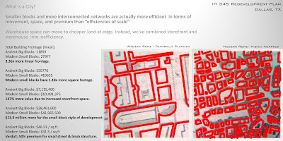
But underneath it all, every city starts with an intersection and expands by intersections, be they abstract or literal. With the size and proportion roughly of "private usable space" with public "conduit," ensures desirability through opportunity which makes for durable, sociopetal, demand-driven places.
Monday, October 15, 2012
Identification and Treatment
Michael Mehaffy shared the following images on the Professional Urbanists Listserv. They are before and after of a hillside slum/favela/informal settlement in Bogota:
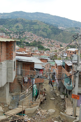
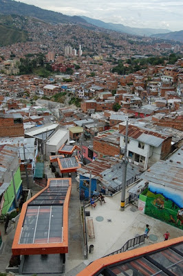
As you can see, hand-made, rickety staircases up the slope were replaced by concrete stairs, terraces, and covered escalators. The point is not to say whether bottom-up or top-down planning and development is better than the other, but instead, that they must work together, in a concerted, forward progress towards an end of improved quality of life and opportunity. The locals (bottom-up) obviously identified the problem, the steep slope that the informal settlement organized around. Then, the commonwealth, which has the ability and resources, formalizes the vertical circulation into a more convenient and improved organizing device for the community.
In many ways, this is no different than the Near South neighborhood in Fort Worth, adding their own bike lanes and road diets, only for the city to see the progress and benefit and thus formalize with re-engineered streets based on the center of community the neighborhood started.
The Pernicious Conceit of Place as "Destination"
A week or so ago I was on a panel at the Dallas Center for Architecture regarding the future of Fair Park. The panel was organized by D Mag arts/culture editor Peter Simek who was inspired by my column from earlier in the year which explored the rise in crime in the nearby area due to the fragmented nature of the area around Fair Park. It is severed from the rest of the city and it has survived as well as if you were to disembody your arm from the rest of your body then toss it onto the floor. We apparently expected it to live, but it only grew gangrenous.
During the panel, I tried to draw parallels with areas of London and Paris where riots occurred within the last few years specifically in areas that were socio-economically as well as physically isolated, disconnected from the surroundings. The point wasn't that we should get the riot gear at the ready, but that there was a connection between physical segregation and socio-economic segregation. The disconnections brought about disinvestment and decay.
At this point, the Fair Park area has bottomed out (we hope, of course) and that it hasn't or won't approach full-on state of Necropolis (again, we hope). So with that shred of veiled optimism, we assume there is nowhere to go but up. But how? And that's what I wanted to focus on.
Too often, whether it is at community meetings or economic development proposals or even private developers the approach is backwards. We talk about what *should* be there, not how to ready the platform for what *should* be there to occur naturally and as a response to the ecology around it, instilling interdependencies and the bonds that provide stability of place.
Here is why: we focus too often on "destinations." How will we get people to visit? And, "but what if people don't show up?!" I suspect there is a notion of 'race to the bottom' unwittingly driving this logic because if the place is desirable enough, people will show up anyway. Too, if a place is desirable enough, people will want to live there, providing stability. Without readying the soil so to speak to cultivate place, we're basically just throwing roses (whatever various uses we try to subsidize) on a grave, expecting them to sprout a rose bush.
Instead, we focus on how do we get people there. "It has to be convenient for them," right? So we build big roads, and ample, free parking specifically for the convenience of others to live far away (often outside of the taxing entity supporting the place). Here is the problem: the roads and parking for the convenience of outsiders is what damages the quality and character of place, making it undesirable to live (disinvestment) and ultimately it undercuts the very demand that the outsiders want to visit over the course of time (decay).
This process encourages 1) rent seeking and 2) the endless process of cannibalism, where location and connectivity no longer matters, only to be replaced by "build it and they will come" ideology, which inevitably leads to cannibalism, instability, and sprawl. There will always be some other place to come along and be better than the older version, because there is no stability of place, location, and desirability of livable, safe neighborhoods with emergent amenities, businesses, and services nearby brought about by the demand of the local population.
The rent seeking is an economic concept describing the process of manipulating policy to extract value. It is particularly pernicious (and usually illegal) form of capitalism. Wealth and value aren't created, but carved off and extracted. In the geography of cities, this is accomplished by creating things like parking, devaluing the local place while maintaining value elsewhere (typically always low everywhere).
When describing this process, I always think of the State Thomas neighborhood in uptown Dallas. People complain that "parking is difficult and inconvenient." Of course it is. That's why it is a desirable place to live. By demanding more convenient parking, you are effectively rent seeking. Looking to take advantage of the desirability of the place while ultimately devaluing it (even though you aren't a stakeholder, resident).
Since State Thomas has matured of the 20 year redevelopment process, it has become less dependent upon McKinney Avenue (the uptown main street) and has reorganized around its own center of gravity, as places are wont to do. This center consists of the restaurants and bars at State and Allen and Thomas and Allen intersections, which mostly act as neighborhood third places, where neighborhood regulars come to visit and enjoy the company of each other, not unlike a typical Barcelona neighborhood bar, but with dogs on leashes replacing the kids playing on the adjacent playground close by.
The one outlier, and this is apparently causing problems with the neighborhood association, is the Nodding Donkey. And I enjoy the Nodding Donkey (and LOVE the architectural redesign blurring the inside sports bar culture with popular Dallas outdoor patio culture). The problem is that it's almost become too popular, drawing cars invading from all over, and generally being louder and more boisterous than the rest of the neighborhood scaled bars. It's more of a McKinney scene than a State-Thomas scene, infuriating the neighborhood.
Generally, these things tend to work themselves out over time, but the underlying issue is that there aren't enough complete neighborhoods like State Thomas, therefore people come from all around to take advantage of it without actually living there. Because the demand for these kinds of places outstrips supply, housing prices remain high. A barrier to most (even though the construction isn't particularly expensive).
And this is how we must first think about anyplace, but Fair Park in its next iteration, as a livable neighborhood first. Like I was quoted long ago in Letters from the Green Line, we have to stop thinking about Fair Park as a DART destination, and first think about it as a DART origin. Then, it will surely be a DART destination in 20 years, rather than a vestige of memories lost.
To do so, we have to start leveraging the excess land occupied by park, parking, and roads. The city has way too much land tied up in both parks and road right-of-way. Too much infrastructure and not enough tax base. Before the panel, I counted up all of the excessive right-of-way based on actual traffic counts compared to the roads full capacity, the surface parking lots at Fair Park, and the right-of-way at SM Wright were it converted to a 4-lane urban boulevard, and found nearly 150 acres of land that could be used to sweeten the pot for potential investors (provided they adhere to certain development standards), leveraging economic development. Maybe some day, the park can actually be a park, a center of daily activity, rather than a place of homogenous, one-off destinations.
Friday, October 5, 2012
Knox Demonstration Road Diet, Before & After
As you may know, Knox Street was identified on the Dallas Complete Streets plan as a road suitable for being, ahem, "completed." The gist of a complete street is that it isn't just for cars, but the infrastructure is essentially balanced for all forms of transportation.
Though Knox is not well-served by mass transit, to complete it without significant changes to the public transportation system, means a road diet. In this case, the road diet took a four lane road and reduced it to two travel lanes in each direction and a shared center turn lane. The leftover space from the removal of the fourth lane became a two-way cycle track, effectively extending the Katy Trail onto Knox as "an urban detour."
Throughout the country, similar road diets such as this one have proved to effectively calm traffic, improve safety, and actually move MORE vehicles with no evidence of any negative economic impact (usually there is economic improvement, but these numbers are harder to come by. This is why I often point out that traffic isn't necessarily a bad thing. Places need energy. But to create a center of gravity that energy must be "condensed into a slow vibration," to paraphrase from physics). Though this seems counter-intuitive, there are two primary reasons: 1) the place is more desirable when it is safer, so more people are attracted to it, and yes, drive there, and 2) the slowed traffic reduces headways between vehicles thereby increasing its overall capacity as more cars can fit on the road. As people drive slower, drivers feel more comfortable being within 2-3 car lengths of other vehicles. There is adequate stopping time and even if something were to happen, at such low speeds, damage would be minimal.
Because I knew this was happening, I decided to take speed readings before the installation and after. Here was my methodology:
- data readings before and during the road diet demonstration were taken at similar times from 12-2pm on a weekday.
- data readings taken shortly after installation was complete, but before any of the programmed festivities so as to avoid distortions to the data.
- measurements were taken using a handheld radar gun from behind vehicles so as to avoid detection and subsequent unnatural slowing thinking I might be 5.0
- vehicular speed measurements were ONLY recorded when there were no break lights present and a green light ahead so as to record only "full speed."
BEFORE:
DURING:
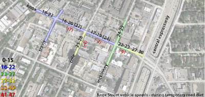
RESULTS
The ranges shown in black at each segment of road show the full range of speeds on those particular street segments.
No vehicle moved along these segments at speeds greater or lower than these ranges with two exceptions. There were only two exceptions. One was a porsche heading towards Highland Park at 27mph and the other was an SUV heading towards 75 at 24 mph.
These are shown in brackets next to the segment where it was recorded.
In red parentheses is the reduction in speed on average per segment.
Predictably, traffic slowed all along Knox where the road diet was installed.
Interestingly, the vehicle speeds as cars entered Knox was the same as before, but then slowed noticeably as they approached McKinney Ave., where the start of the road diet was visible.
NOTES
- The vast majority of vehicles actually moved slower than above, as most approached red lights or used their brakes. As noted, these were not recorded.
- During the time of recording, traffic generally moved at a steady flow, generally 1-3 car lengths apart. Stacking at red lights rarely over a few cars at a time.
- Choke points/backups/conflicts occurred not at intersections but at mid-block alleys, curbcuts, and crossing traffic into on-street parking.
- There were more pedestrians present at this time than before, though not in overwhelming numbers. Also, it was 92 degrees during, and 98 degrees when the Before measurements were taken.
- The right turn only lane from Knox to McKinney was critical in reducing conflicts.
How “Tethered” is the street?
A street can be considered knitted together based on the degree to which pedestrians are willing to cross a road for various reasons including cross-shopping, an intricate component to synergy of place. How knitted a street is, is a measure of inherent pedestrian comfort and confidence in their safety.
- A road where pedestrians do not cross at all can be considered to have 0 knitted value.
- Where they cross only at control points, such as crosswalks and intersections is a 1.
- Where pedestrians cross at desire lines, a road can be considered to have a ‘knitted’ value of 2.
Lemmon Ave, a zero for integration
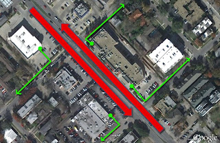
Greenville Ave, lose the zero, get with the one?
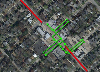
Main Street, lose the zero and the one and get with the hero, a 2.
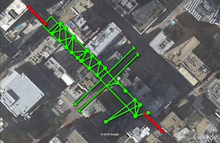
Based on observation, it is believed that Knox as it is currently designed and operating generally functions as a 1 or slightly below. When pedestrians cross, they will use the crosswalks at signalized intersections. However, there seems to be little evidence of cross-shopping, partially due to tenant mix/location, and partially due to road design.
During the demonstration project however, pedestrian crossing at intersections was rare as most crossed where they pleased, at desire lines between origin and destination. Though pedestrian activity at the time was relatively low (compared to Main Street as shown above, though higher than normal), it operated closer to a 2. As traffic speeds were suitably reduced by the demonstration road diet to below 20 mph, pedestrians felt more comfortable to cross the street without using crosswalks or waiting for the crossing signal.
Though Knox is not well-served by mass transit, to complete it without significant changes to the public transportation system, means a road diet. In this case, the road diet took a four lane road and reduced it to two travel lanes in each direction and a shared center turn lane. The leftover space from the removal of the fourth lane became a two-way cycle track, effectively extending the Katy Trail onto Knox as "an urban detour."
Throughout the country, similar road diets such as this one have proved to effectively calm traffic, improve safety, and actually move MORE vehicles with no evidence of any negative economic impact (usually there is economic improvement, but these numbers are harder to come by. This is why I often point out that traffic isn't necessarily a bad thing. Places need energy. But to create a center of gravity that energy must be "condensed into a slow vibration," to paraphrase from physics). Though this seems counter-intuitive, there are two primary reasons: 1) the place is more desirable when it is safer, so more people are attracted to it, and yes, drive there, and 2) the slowed traffic reduces headways between vehicles thereby increasing its overall capacity as more cars can fit on the road. As people drive slower, drivers feel more comfortable being within 2-3 car lengths of other vehicles. There is adequate stopping time and even if something were to happen, at such low speeds, damage would be minimal.
Because I knew this was happening, I decided to take speed readings before the installation and after. Here was my methodology:
- data readings before and during the road diet demonstration were taken at similar times from 12-2pm on a weekday.
- data readings taken shortly after installation was complete, but before any of the programmed festivities so as to avoid distortions to the data.
- measurements were taken using a handheld radar gun from behind vehicles so as to avoid detection and subsequent unnatural slowing thinking I might be 5.0
- vehicular speed measurements were ONLY recorded when there were no break lights present and a green light ahead so as to record only "full speed."
BEFORE:
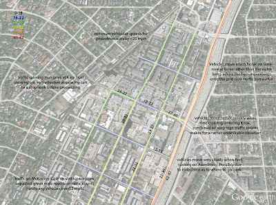
DURING:

RESULTS
The ranges shown in black at each segment of road show the full range of speeds on those particular street segments.
No vehicle moved along these segments at speeds greater or lower than these ranges with two exceptions. There were only two exceptions. One was a porsche heading towards Highland Park at 27mph and the other was an SUV heading towards 75 at 24 mph.
These are shown in brackets next to the segment where it was recorded.
In red parentheses is the reduction in speed on average per segment.
Predictably, traffic slowed all along Knox where the road diet was installed.
Interestingly, the vehicle speeds as cars entered Knox was the same as before, but then slowed noticeably as they approached McKinney Ave., where the start of the road diet was visible.
NOTES
- The vast majority of vehicles actually moved slower than above, as most approached red lights or used their brakes. As noted, these were not recorded.
- During the time of recording, traffic generally moved at a steady flow, generally 1-3 car lengths apart. Stacking at red lights rarely over a few cars at a time.
- Choke points/backups/conflicts occurred not at intersections but at mid-block alleys, curbcuts, and crossing traffic into on-street parking.
- There were more pedestrians present at this time than before, though not in overwhelming numbers. Also, it was 92 degrees during, and 98 degrees when the Before measurements were taken.
- The right turn only lane from Knox to McKinney was critical in reducing conflicts.
How “Tethered” is the street?
A street can be considered knitted together based on the degree to which pedestrians are willing to cross a road for various reasons including cross-shopping, an intricate component to synergy of place. How knitted a street is, is a measure of inherent pedestrian comfort and confidence in their safety.
- A road where pedestrians do not cross at all can be considered to have 0 knitted value.
- Where they cross only at control points, such as crosswalks and intersections is a 1.
- Where pedestrians cross at desire lines, a road can be considered to have a ‘knitted’ value of 2.
Lemmon Ave, a zero for integration
Greenville Ave, lose the zero, get with the one?
Main Street, lose the zero and the one and get with the hero, a 2.
Based on observation, it is believed that Knox as it is currently designed and operating generally functions as a 1 or slightly below. When pedestrians cross, they will use the crosswalks at signalized intersections. However, there seems to be little evidence of cross-shopping, partially due to tenant mix/location, and partially due to road design.
During the demonstration project however, pedestrian crossing at intersections was rare as most crossed where they pleased, at desire lines between origin and destination. Though pedestrian activity at the time was relatively low (compared to Main Street as shown above, though higher than normal), it operated closer to a 2. As traffic speeds were suitably reduced by the demonstration road diet to below 20 mph, pedestrians felt more comfortable to cross the street without using crosswalks or waiting for the crossing signal.
Walkability Schmalkability: Cognitive Dissonance of Simulation and Simulacra
Don't always believe what you hear or read (even this!). I don't even know how I came across this article about a supposedly new urbanist-y new development in Illinois, but it couldn't be a better possible example of when terms like walkability, livability, sustainability, etc. become completely disembodied from any real meaning, and in turn, become marketese, empty vague vessels for you, the consumer, to fill with whatever happy thoughts you might.
For example:
Behold:
Hmmm. That looks suspiciously like a diamond freeway interchange. Not looking good so far for that promise of walkability...
Hmmm again. That looks like a conventional suburban development. I count one (1) strip center, thirteen pad sites (13), one (1) cul-de-sac, no (0) access between the residential and retail, and zero (0) homes that actually front on the waterfront park/lake thing, essentially privatizing it. Might as well put a golf course in there and throw a gate around it and call it a day.
Oh, and this is from a firm in Texas.
For example:
The idea, he explained, is about “a sense of place, diversity and connectivity.”
“People need to be able to walk out their door, walk to the park, walk to their neighbors, walk to the shops, without having the need to get in their car every time they need to go somewhere,” he said.
Behold:
Hmmm. That looks suspiciously like a diamond freeway interchange. Not looking good so far for that promise of walkability...
Hmmm again. That looks like a conventional suburban development. I count one (1) strip center, thirteen pad sites (13), one (1) cul-de-sac, no (0) access between the residential and retail, and zero (0) homes that actually front on the waterfront park/lake thing, essentially privatizing it. Might as well put a golf course in there and throw a gate around it and call it a day.
Oh, and this is from a firm in Texas.
Subscribe to:
Posts (Atom)


